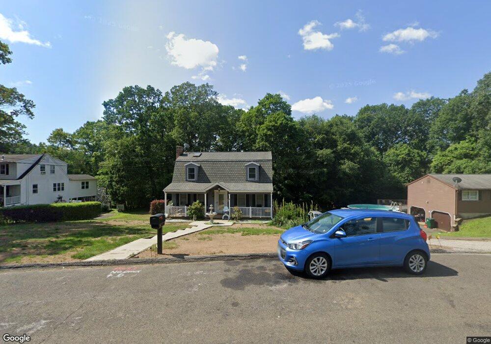
6 Molsick Rd Seymour, CT 06483
Estimated Value: $496,000 - $548,000
4
Beds
3
Baths
2,870
Sq Ft
$181/Sq Ft
Est. Value
About This Home
This home is located at 6 Molsick Rd, Seymour, CT 06483 and is currently estimated at $518,854, approximately $180 per square foot. 6 Molsick Rd is a home located in New Haven County with nearby schools including Seymour Middle School and Seymour High School.
Ownership History
Date
Name
Owned For
Owner Type
Purchase Details
Closed on
Oct 29, 1999
Sold by
Perez Roger and Perez Kim
Bought by
Tryjada John M and Tryjada Lynette K
Current Estimated Value
Purchase Details
Closed on
Apr 30, 1996
Sold by
Mcmahon James A and Mcmahon Joanne E
Bought by
Perez Kim and Perez Roger
Purchase Details
Closed on
Oct 1, 1991
Sold by
Scanzoni James and Scanzoni Mary
Bought by
Mcmahon James and Mcmahon Johanne
Create a Home Valuation Report for This Property
The Home Valuation Report is an in-depth analysis detailing your home's value as well as a comparison with similar homes in the area
Home Values in the Area
Average Home Value in this Area
Purchase History
| Date | Buyer | Sale Price | Title Company |
|---|---|---|---|
| Tryjada John M | $176,000 | -- | |
| Perez Kim | $146,500 | -- | |
| Tryjada John M | $176,000 | -- | |
| Perez Kim | $146,500 | -- | |
| Mcmahon James | $142,500 | -- |
Source: Public Records
Mortgage History
| Date | Status | Borrower | Loan Amount |
|---|---|---|---|
| Open | Mcmahon James | $178,600 | |
| Closed | Mcmahon James | $188,500 | |
| Closed | Mcmahon James | $100,000 |
Source: Public Records
Tax History Compared to Growth
Tax History
| Year | Tax Paid | Tax Assessment Tax Assessment Total Assessment is a certain percentage of the fair market value that is determined by local assessors to be the total taxable value of land and additions on the property. | Land | Improvement |
|---|---|---|---|---|
| 2025 | $8,945 | $322,700 | $52,290 | $270,410 |
| 2024 | $7,976 | $216,510 | $42,490 | $174,020 |
| 2023 | $7,790 | $216,510 | $42,490 | $174,020 |
| 2022 | $7,706 | $216,510 | $42,490 | $174,020 |
| 2021 | $7,515 | $216,510 | $42,490 | $174,020 |
| 2020 | $7,051 | $195,860 | $49,910 | $145,950 |
| 2019 | $7,051 | $195,860 | $49,910 | $145,950 |
| 2018 | $7,051 | $195,860 | $49,910 | $145,950 |
| 2017 | $7,051 | $195,860 | $49,910 | $145,950 |
| 2016 | $7,051 | $195,860 | $49,910 | $145,950 |
| 2015 | $6,220 | $179,830 | $54,880 | $124,950 |
| 2014 | $6,350 | $186,550 | $54,880 | $131,670 |
Source: Public Records
Map
Nearby Homes
- 31 Skokorat St
- 10 Highland Ave
- 10 Miller Rd
- 35 Cogwheel Ln
- 80 North St
- 32 Roberts St
- 21 Great Oak Ridge Way Unit 21
- 17 Meadow St Unit 23
- 58 Anthony Ct
- 5 Forest Hollow Rd
- 226 Walnut St
- 58 Acorn Hill Rd
- 60 Acorn Hill Rd
- 167 Bethmour Rd
- 38 Sanford St
- 72D Walnut St
- 16 3rd St
- 26-28 S Main St
- 9 Wooster St
- 77 S Main St