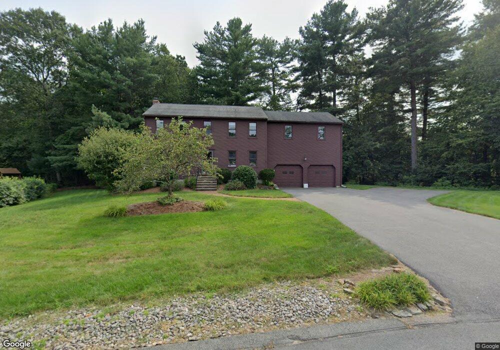
6 Moore Rd Hopedale, MA 01747
Estimated Value: $666,576 - $826,000
4
Beds
3
Baths
2,840
Sq Ft
$256/Sq Ft
Est. Value
About This Home
This home is located at 6 Moore Rd, Hopedale, MA 01747 and is currently estimated at $728,394, approximately $256 per square foot. 6 Moore Rd is a home located in Worcester County with nearby schools including Memorial Elementary School and Hopedale Jr Sr High School.
Ownership History
Date
Name
Owned For
Owner Type
Purchase Details
Closed on
Dec 10, 1993
Sold by
Garvey Stephen W and Garvey Megan
Bought by
Davis Christopher and Lynne Davis M
Current Estimated Value
Purchase Details
Closed on
Dec 18, 1987
Sold by
W G B Constr Co
Bought by
Garvey Stephen W
Create a Home Valuation Report for This Property
The Home Valuation Report is an in-depth analysis detailing your home's value as well as a comparison with similar homes in the area
Home Values in the Area
Average Home Value in this Area
Purchase History
| Date | Buyer | Sale Price | Title Company |
|---|---|---|---|
| Davis Christopher | $171,000 | -- | |
| Garvey Stephen W | $180,735 | -- |
Source: Public Records
Mortgage History
| Date | Status | Borrower | Loan Amount |
|---|---|---|---|
| Open | Garvey Stephen W | $198,500 | |
| Closed | Garvey Stephen W | $70,000 |
Source: Public Records
Tax History
| Year | Tax Paid | Tax Assessment Tax Assessment Total Assessment is a certain percentage of the fair market value that is determined by local assessors to be the total taxable value of land and additions on the property. | Land | Improvement |
|---|---|---|---|---|
| 2025 | $9,265 | $557,800 | $194,800 | $363,000 |
| 2024 | $8,831 | $532,000 | $185,400 | $346,600 |
| 2023 | $8,027 | $497,000 | $182,300 | $314,700 |
| 2022 | $7,831 | $457,700 | $167,100 | $290,600 |
| 2021 | $7,507 | $420,100 | $151,900 | $268,200 |
| 2020 | $7,314 | $420,100 | $151,900 | $268,200 |
| 2019 | $6,965 | $396,400 | $151,900 | $244,500 |
| 2018 | $6,724 | $382,500 | $144,800 | $237,700 |
| 2017 | $6,273 | $362,800 | $138,000 | $224,800 |
| 2016 | $6,035 | $358,600 | $138,000 | $220,600 |
| 2015 | $5,639 | $340,100 | $128,600 | $211,500 |
Source: Public Records
Map
Nearby Homes
- 2 Northrop St
- 11 Deluca Rd
- 0 West St
- 17 Forest Park Dr
- 8 Country Club Ln Unit B
- 11 Country Club Ln Unit D
- 14 Country Club Ln Unit C
- 147 Laurelwood Dr
- 59 Lawrence St
- 6 Correia Cir Unit B
- 2 Lee St Unit B
- 14 C Country Club Ln
- 14 Lawrence St
- 9 Ariana Cir Unit 9
- 8 Bandy Ln
- 6 1/2 Leonard St
- 16 Heron Ln
- 31-33 Vine St
- 34 Rawson Farm Rd
- 8 Washington St
Your Personal Tour Guide
Ask me questions while you tour the home.