Estimated Value: $282,000 - $328,000
5
Beds
2
Baths
3,318
Sq Ft
$92/Sq Ft
Est. Value
About This Home
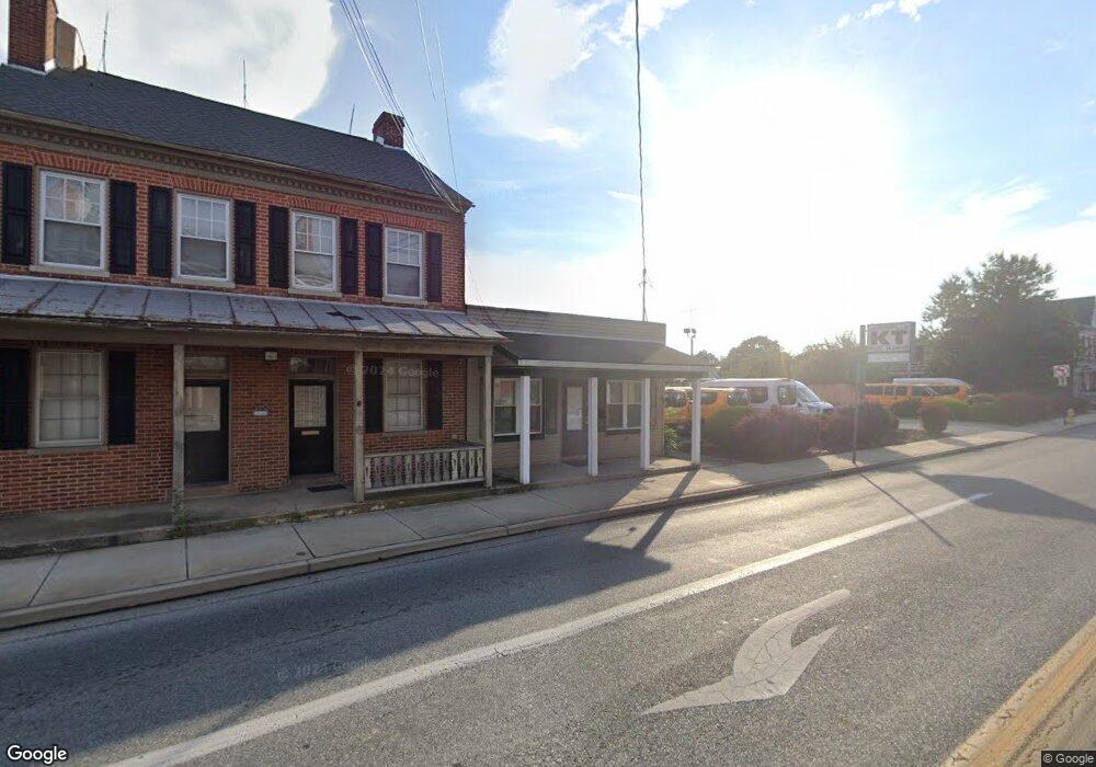
This home is located at 6 N Main St, Dover, PA 17315 and is currently estimated at $303,999, approximately $91 per square foot. 6 N Main St is a home located in York County with nearby schools including Dover Area High School and Lighthouse Christian School.
Ownership History
Date
Name
Owned For
Owner Type
Purchase Details
Closed on
Aug 6, 2012
Sold by
Nehorah Gordon and Bangbeor Nehorah Siah
Bought by
Bangbeor Nehorah Siah
Current Estimated Value
Purchase Details
Closed on
Sep 22, 2006
Sold by
Palmer Diane
Bought by
Bangbeor Nehorah Siah and Nehorah Gordon
Home Financials for this Owner
Home Financials are based on the most recent Mortgage that was taken out on this home.
Original Mortgage
$149,600
Outstanding Balance
$91,445
Interest Rate
7%
Mortgage Type
Purchase Money Mortgage
Estimated Equity
$212,554
Create a Home Valuation Report for This Property
The Home Valuation Report is an in-depth analysis detailing your home's value as well as a comparison with similar homes in the area
Home Values in the Area
Average Home Value in this Area
Purchase History
| Date | Buyer | Sale Price | Title Company |
|---|---|---|---|
| Bangbeor Nehorah Siah | -- | None Available | |
| Bangbeor Nehorah Siah | $187,000 | None Available |
Source: Public Records
Mortgage History
| Date | Status | Borrower | Loan Amount |
|---|---|---|---|
| Open | Bangbeor Nehorah Siah | $149,600 |
Source: Public Records
Tax History Compared to Growth
Tax History
| Year | Tax Paid | Tax Assessment Tax Assessment Total Assessment is a certain percentage of the fair market value that is determined by local assessors to be the total taxable value of land and additions on the property. | Land | Improvement |
|---|---|---|---|---|
| 2025 | $5,558 | $158,140 | $25,370 | $132,770 |
| 2024 | $5,558 | $158,140 | $25,370 | $132,770 |
| 2023 | $5,558 | $158,140 | $25,370 | $132,770 |
| 2022 | $5,465 | $158,140 | $25,370 | $132,770 |
| 2021 | $5,180 | $158,140 | $25,370 | $132,770 |
| 2020 | $5,137 | $158,140 | $25,370 | $132,770 |
| 2019 | $5,039 | $158,140 | $25,370 | $132,770 |
| 2018 | $4,969 | $158,140 | $25,370 | $132,770 |
| 2017 | $4,969 | $158,140 | $25,370 | $132,770 |
| 2016 | $0 | $158,140 | $25,370 | $132,770 |
| 2015 | -- | $158,140 | $25,370 | $132,770 |
| 2014 | -- | $158,140 | $25,370 | $132,770 |
Source: Public Records
Map
Nearby Homes
- 33 S Main St
- 0 W Canal Rd
- 1841 Wyatt Cir
- 4013 Somerset Rd
- 4008 Country Dr
- 2063 Wyatt Cir
- 3975 Craig Ave
- 3960 Sheppard Dr
- 2041 Shaffer Cir
- 2856 W Canal Rd
- 86 Cherokee Ave
- 2689 Victorian Dr
- 2697 Victorian Dr
- 2653 Victorian Dr
- 2637 Victorian Dr
- 2645 Victorian Dr
- 2641 Victorian Dr
- 2673 Victorian Dr
- 2685 Victorian Dr
- 2538 Brownstone Ct
- Lot # 6 Carlisle Rd
- Lot 6 Carlisle Rd
- 8 N Main St
- 8 N Main St Unit LEASE
- 2 Carlisle Rd
- 5 Carlisle Rd
- 4 N Main St
- 2 N Main St
- 4 Carlisle Rd
- Lot 4 Carlisle Rd
- 18 N Main St
- 17 -19 N Main St
- 20 N Main St
- 17 N Main St
- 17 N Main St
- 00 W Canal St
- 8 S Main St Unit 2nd Floor
- 8 S Main St Unit First Floor
- 8 S Main St
- 3 Carlisle Rd