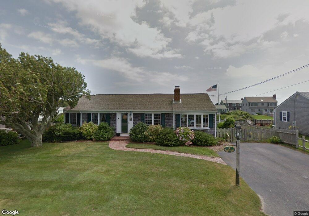
6 Port Way West Dennis, MA 02670
West Dennis NeighborhoodEstimated Value: $1,567,000 - $2,007,000
3
Beds
2
Baths
1,576
Sq Ft
$1,137/Sq Ft
Est. Value
About This Home
This home is located at 6 Port Way, West Dennis, MA 02670 and is currently estimated at $1,791,490, approximately $1,136 per square foot. 6 Port Way is a home located in Barnstable County with nearby schools including Dennis-Yarmouth Regional High School and St. Pius X. School.
Ownership History
Date
Name
Owned For
Owner Type
Purchase Details
Closed on
Aug 18, 2023
Sold by
Robert M Lecke T M and Robert Lecke
Bought by
Mccarthy Adam C and Mccarthy Elizabeth A
Current Estimated Value
Home Financials for this Owner
Home Financials are based on the most recent Mortgage that was taken out on this home.
Original Mortgage
$150,000
Outstanding Balance
$146,287
Interest Rate
6.81%
Mortgage Type
Purchase Money Mortgage
Estimated Equity
$1,645,203
Purchase Details
Closed on
Dec 23, 2013
Sold by
Lecke Ft and Lecke
Bought by
Roberta M Lecke T M and Roberta Treacy
Create a Home Valuation Report for This Property
The Home Valuation Report is an in-depth analysis detailing your home's value as well as a comparison with similar homes in the area
Home Values in the Area
Average Home Value in this Area
Purchase History
| Date | Buyer | Sale Price | Title Company |
|---|---|---|---|
| Mccarthy Adam C | $1,550,000 | None Available | |
| Roberta M Lecke T M | -- | -- | |
| Roberta M Lecke T M | -- | -- |
Source: Public Records
Mortgage History
| Date | Status | Borrower | Loan Amount |
|---|---|---|---|
| Open | Mccarthy Adam C | $150,000 | |
| Previous Owner | Roberta M Lecke T M | $10,750 |
Source: Public Records
Tax History Compared to Growth
Tax History
| Year | Tax Paid | Tax Assessment Tax Assessment Total Assessment is a certain percentage of the fair market value that is determined by local assessors to be the total taxable value of land and additions on the property. | Land | Improvement |
|---|---|---|---|---|
| 2025 | $6,567 | $1,516,700 | $1,011,100 | $505,600 |
| 2024 | $6,395 | $1,456,700 | $972,300 | $484,400 |
| 2023 | $6,185 | $1,324,500 | $883,900 | $440,600 |
| 2022 | $4,879 | $871,200 | $546,000 | $325,200 |
| 2021 | $5,023 | $833,000 | $535,300 | $297,700 |
| 2020 | $4,916 | $805,900 | $535,300 | $270,600 |
| 2019 | $4,846 | $785,400 | $524,800 | $260,600 |
| 2018 | $5,150 | $812,300 | $572,400 | $239,900 |
| 2017 | $4,822 | $784,000 | $551,600 | $232,400 |
| 2016 | $5,204 | $796,900 | $598,500 | $198,400 |
| 2015 | $5,100 | $796,900 | $598,500 | $198,400 |
| 2014 | $5,060 | $796,900 | $598,500 | $198,400 |
Source: Public Records
Map
Nearby Homes
- 2 Rita Mary Way
- 14 Schoolhouse Ln
- 178 School St
- 209 Main St Unit 3
- 209 Main St Unit 6
- 209 Main St Unit 1
- 209 Main St Unit 2
- 209 Main St Unit 4
- 209 Main St Unit 5
- 23 Doric Ave
- 308 Old Main St
- 401 Main St Unit 201
- 401 Main St Unit 101
- 45 Seth Ln
- 467 Main St
- 428 Main St Unit 1-11
- 6 Baker Way
- 745 Willow St
- 29 Bass River Rd
- 22 Powhatan Rd