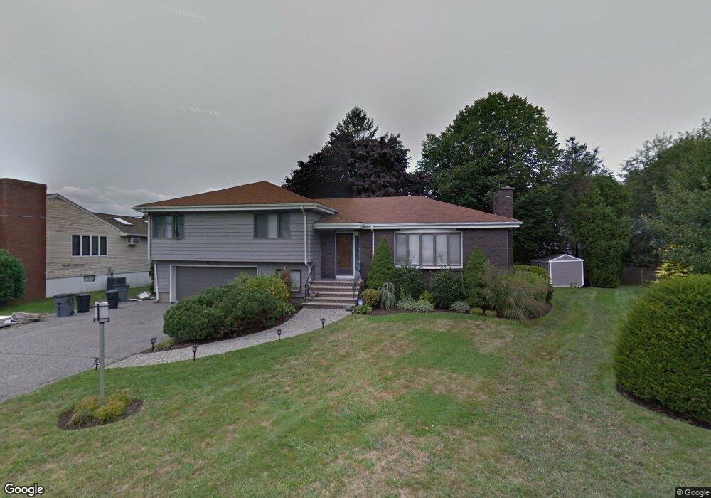
6 Robin Ln Swampscott, MA 01907
Estimated Value: $879,000 - $1,296,000
3
Beds
3
Baths
2,175
Sq Ft
$509/Sq Ft
Est. Value
About This Home
This home is located at 6 Robin Ln, Swampscott, MA 01907 and is currently estimated at $1,106,651, approximately $508 per square foot. 6 Robin Ln is a home located in Essex County with nearby schools including Swampscott Middle School and Swampscott High School.
Ownership History
Date
Name
Owned For
Owner Type
Purchase Details
Closed on
Oct 28, 2020
Sold by
Cook Justin
Bought by
Bruner Cassie and Bruner Jeffrey
Current Estimated Value
Home Financials for this Owner
Home Financials are based on the most recent Mortgage that was taken out on this home.
Original Mortgage
$448,710
Outstanding Balance
$395,627
Interest Rate
2.8%
Mortgage Type
New Conventional
Estimated Equity
$711,024
Purchase Details
Closed on
Mar 29, 2010
Sold by
Goldman James A and Goldman Carol A
Bought by
Cook Justin
Home Financials for this Owner
Home Financials are based on the most recent Mortgage that was taken out on this home.
Original Mortgage
$417,000
Interest Rate
5.02%
Mortgage Type
Purchase Money Mortgage
Purchase Details
Closed on
Aug 1, 1988
Sold by
Angelopulos Charles
Bought by
Goldman James A
Create a Home Valuation Report for This Property
The Home Valuation Report is an in-depth analysis detailing your home's value as well as a comparison with similar homes in the area
Home Values in the Area
Average Home Value in this Area
Purchase History
| Date | Buyer | Sale Price | Title Company |
|---|---|---|---|
| Bruner Cassie | $560,888 | None Available | |
| Bruner Cassie | $560,888 | None Available | |
| Bruner Cassie | $560,888 | None Available | |
| Bruner Cassie | $560,888 | None Available | |
| Cook Justin | $542,000 | -- | |
| Cook Justin | $542,000 | -- | |
| Goldman James A | $463,000 | -- |
Source: Public Records
Mortgage History
| Date | Status | Borrower | Loan Amount |
|---|---|---|---|
| Open | Bruner Cassie | $448,710 | |
| Closed | Bruner Cassie | $448,710 | |
| Previous Owner | Goldman James A | $397,000 | |
| Previous Owner | Goldman James A | $417,000 |
Source: Public Records
Tax History
| Year | Tax Paid | Tax Assessment Tax Assessment Total Assessment is a certain percentage of the fair market value that is determined by local assessors to be the total taxable value of land and additions on the property. | Land | Improvement |
|---|---|---|---|---|
| 2025 | $11,944 | $1,041,300 | $479,000 | $562,300 |
| 2024 | $11,281 | $981,800 | $448,400 | $533,400 |
| 2023 | $10,621 | $904,700 | $407,600 | $497,100 |
| 2022 | $9,761 | $760,800 | $346,500 | $414,300 |
| 2021 | $9,329 | $676,000 | $285,400 | $390,600 |
| 2020 | $9,665 | $675,900 | $285,400 | $390,500 |
| 2019 | $9,964 | $655,500 | $265,000 | $390,500 |
| 2018 | $10,386 | $649,100 | $265,000 | $384,100 |
| 2017 | $10,395 | $595,700 | $236,900 | $358,800 |
| 2016 | $9,937 | $573,400 | $236,900 | $336,500 |
| 2015 | $9,834 | $573,400 | $236,900 | $336,500 |
| 2014 | $9,118 | $487,600 | $203,800 | $283,800 |
Source: Public Records
Map
Nearby Homes
- 315 Puritan Rd
- 22 Hemenway Rd
- 110 Galloupes Point Rd
- 35 Alden Rd
- 38 Puritan Rd
- 75 Bay View Dr
- 71 Walnut Rd
- 245 Humphrey St Unit 205
- 27 Rockland St
- 2 Ocean Ave
- 49 Blaney St
- 133 Elmwood Rd Unit 2
- 168 Humphrey St Unit PH
- 48 Mountwood Rd
- 50 Mountwood Rd
- 167-169 Walker Rd
- 169 Walker Rd Unit 2
- 3 Didio Dr
- 28 Claremont Terrace Unit 6
- 100 Burrill St Unit 6
Your Personal Tour Guide
Ask me questions while you tour the home.