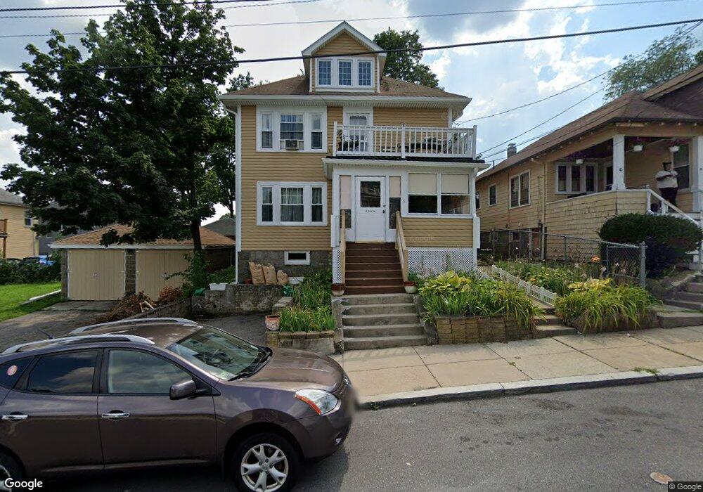
6 Ruxton Rd Mattapan, MA 02126
Southern Mattapan NeighborhoodEstimated Value: $688,025 - $826,000
4
Beds
2
Baths
2,496
Sq Ft
$305/Sq Ft
Est. Value
About This Home
This home is located at 6 Ruxton Rd, Mattapan, MA 02126 and is currently estimated at $760,756, approximately $304 per square foot. 6 Ruxton Rd is a home located in Suffolk County with nearby schools including KIPP Academy Boston Charter School, Boston Preparatory Charter Public School, and Berea Seventh-day Adventist Academy.
Ownership History
Date
Name
Owned For
Owner Type
Purchase Details
Closed on
Jul 12, 1999
Sold by
Chin Lavonda S and Ocwen Fedl Bk Fsb
Bought by
Nelson Cheryl
Current Estimated Value
Create a Home Valuation Report for This Property
The Home Valuation Report is an in-depth analysis detailing your home's value as well as a comparison with similar homes in the area
Home Values in the Area
Average Home Value in this Area
Purchase History
| Date | Buyer | Sale Price | Title Company |
|---|---|---|---|
| Nelson Cheryl | $133,000 | -- |
Source: Public Records
Mortgage History
| Date | Status | Borrower | Loan Amount |
|---|---|---|---|
| Open | Nelson Cheryl | $30,442 | |
| Closed | Nelson Cheryl | $10,000 |
Source: Public Records
Tax History Compared to Growth
Tax History
| Year | Tax Paid | Tax Assessment Tax Assessment Total Assessment is a certain percentage of the fair market value that is determined by local assessors to be the total taxable value of land and additions on the property. | Land | Improvement |
|---|---|---|---|---|
| 2025 | $6,346 | $548,000 | $182,300 | $365,700 |
| 2024 | $5,514 | $505,900 | $162,700 | $343,200 |
| 2023 | $5,126 | $477,300 | $153,500 | $323,800 |
| 2022 | $5,193 | $477,300 | $153,500 | $323,800 |
| 2021 | $4,630 | $433,900 | $139,500 | $294,400 |
| 2020 | $4,574 | $433,100 | $139,400 | $293,700 |
| 2019 | $4,228 | $401,100 | $100,700 | $300,400 |
| 2018 | $3,754 | $358,200 | $100,700 | $257,500 |
| 2017 | $3,647 | $344,400 | $100,700 | $243,700 |
| 2016 | $3,444 | $313,100 | $100,700 | $212,400 |
| 2015 | $3,170 | $261,800 | $93,100 | $168,700 |
| 2014 | $2,930 | $232,900 | $93,100 | $139,800 |
Source: Public Records
Map
Nearby Homes
- 34 Ridlon Rd
- 839-843 Cummins Hwy
- 231 Itasca St
- 770 Cummins Hwy Unit 1
- 770 Cummins Hwy Unit 22
- 179 Hebron St
- 265 Hebron St
- 10 Brockton St
- 90 Hollingsworth St
- 72 Livermore St
- 0 Tina Ave
- 23 Caton St
- 95 Woodhaven St
- 7 Winborough St
- 25 Alpine St Unit 7
- 48-50 Rockdale St
- 100 Itasca St
- 645 River St
- 20 Monterey Ave
- 60 and 64 Monterey Ave