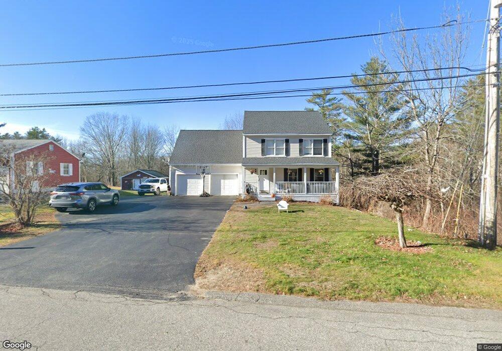
6 Skyline Dr Saco, ME 04072
Central Saco NeighborhoodEstimated Value: $528,340 - $589,000
4
Beds
3
Baths
1,848
Sq Ft
$307/Sq Ft
Est. Value
About This Home
This home is located at 6 Skyline Dr, Saco, ME 04072 and is currently estimated at $566,835, approximately $306 per square foot. 6 Skyline Dr is a home located in York County with nearby schools including C K Burns School, Saco Middle School, and Saint James School.
Ownership History
Date
Name
Owned For
Owner Type
Purchase Details
Closed on
Jun 1, 2006
Sold by
Eon Kenneth R and Eon Kandace B
Bought by
Ray Jeremy A and Hussey Suzanne M
Current Estimated Value
Home Financials for this Owner
Home Financials are based on the most recent Mortgage that was taken out on this home.
Original Mortgage
$252,000
Outstanding Balance
$83,779
Interest Rate
6.55%
Mortgage Type
Unknown
Estimated Equity
$483,056
Create a Home Valuation Report for This Property
The Home Valuation Report is an in-depth analysis detailing your home's value as well as a comparison with similar homes in the area
Home Values in the Area
Average Home Value in this Area
Purchase History
| Date | Buyer | Sale Price | Title Company |
|---|---|---|---|
| Ray Jeremy A | -- | -- |
Source: Public Records
Mortgage History
| Date | Status | Borrower | Loan Amount |
|---|---|---|---|
| Open | Ray Jeremy A | $252,000 | |
| Closed | Ray Jeremy A | $31,500 |
Source: Public Records
Tax History
| Year | Tax Paid | Tax Assessment Tax Assessment Total Assessment is a certain percentage of the fair market value that is determined by local assessors to be the total taxable value of land and additions on the property. | Land | Improvement |
|---|---|---|---|---|
| 2024 | $6,057 | $431,100 | $126,800 | $304,300 |
| 2023 | $6,359 | $431,100 | $126,800 | $304,300 |
| 2022 | $5,743 | $313,300 | $96,300 | $217,000 |
| 2021 | $5,502 | $291,400 | $86,200 | $205,200 |
| 2020 | $4,551 | $266,900 | $75,800 | $191,100 |
| 2019 | $5,173 | $266,900 | $75,800 | $191,100 |
| 2018 | $5,039 | $260,000 | $68,900 | $191,100 |
| 2017 | $5,083 | $262,300 | $68,900 | $193,400 |
| 2016 | $4,350 | $275,500 | $65,300 | $210,200 |
| 2015 | $5,224 | $271,800 | $64,100 | $207,700 |
| 2014 | $5,061 | $271,800 | $64,100 | $207,700 |
| 2013 | -- | $271,800 | $64,100 | $207,700 |
Source: Public Records
Map
Nearby Homes
- TBD Oakland St
- 242 Lincoln St
- 7 Hubbard St
- 13 Western Ave
- 16 Caryn Dr
- 2 Banks Ln
- 75 Maple St Unit 101
- 57 Hill St
- 22 Tasker St Unit 11
- 22 Tasker St Unit 10
- 18A Garfield St
- 91 Western Ave Unit 3
- 2 Labonte Ave E
- 3 Labonte Ave E
- 64 Bradbury St
- 674 South St
- 70 Mason St
- 4 Kossuth St
- 11 Chadwick Place
- 12 Kossuth St
Your Personal Tour Guide
Ask me questions while you tour the home.