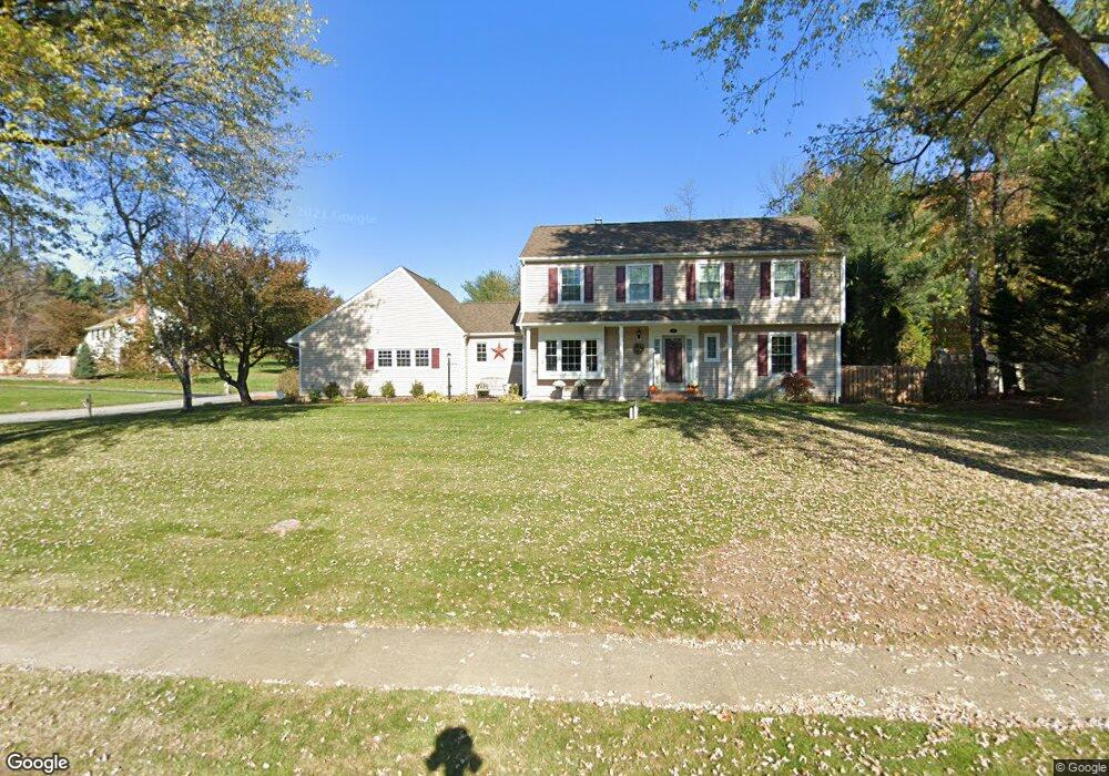
6 Sparrow Rd Randolph, NJ 07869
Estimated Value: $840,129 - $949,000
4
Beds
3
Baths
2,572
Sq Ft
$347/Sq Ft
Est. Value
About This Home
This home is located at 6 Sparrow Rd, Randolph, NJ 07869 and is currently estimated at $893,532, approximately $347 per square foot. 6 Sparrow Rd is a home located in Morris County with nearby schools including Randolph High School, Randolph Middle School, and Apple Montessori Schools and Camps - Randolph.
Ownership History
Date
Name
Owned For
Owner Type
Purchase Details
Closed on
Jan 31, 2001
Sold by
Wyckoff John C and Wyckoff Judythe E
Bought by
Roche William R and Roche Jayne M
Current Estimated Value
Home Financials for this Owner
Home Financials are based on the most recent Mortgage that was taken out on this home.
Original Mortgage
$255,000
Outstanding Balance
$91,353
Interest Rate
7.14%
Estimated Equity
$802,179
Create a Home Valuation Report for This Property
The Home Valuation Report is an in-depth analysis detailing your home's value as well as a comparison with similar homes in the area
Home Values in the Area
Average Home Value in this Area
Purchase History
| Date | Buyer | Sale Price | Title Company |
|---|---|---|---|
| Roche William R | $395,000 | -- |
Source: Public Records
Mortgage History
| Date | Status | Borrower | Loan Amount |
|---|---|---|---|
| Open | Roche William R | $255,000 |
Source: Public Records
Tax History
| Year | Tax Paid | Tax Assessment Tax Assessment Total Assessment is a certain percentage of the fair market value that is determined by local assessors to be the total taxable value of land and additions on the property. | Land | Improvement |
|---|---|---|---|---|
| 2025 | $14,033 | $495,700 | $203,000 | $292,700 |
| 2024 | $13,681 | $495,700 | $203,000 | $292,700 |
| 2023 | $13,681 | $495,700 | $203,000 | $292,700 |
| 2022 | $13,146 | $495,700 | $203,000 | $292,700 |
| 2021 | $13,146 | $495,700 | $203,000 | $292,700 |
| 2020 | $13,012 | $495,700 | $203,000 | $292,700 |
| 2019 | $12,863 | $495,700 | $203,000 | $292,700 |
| 2018 | $12,700 | $495,700 | $203,000 | $292,700 |
| 2017 | $12,541 | $495,700 | $203,000 | $292,700 |
| 2016 | $12,740 | $348,100 | $137,100 | $211,000 |
| 2015 | $12,587 | $348,100 | $137,100 | $211,000 |
| 2014 | $12,154 | $341,400 | $137,100 | $204,300 |
Source: Public Records
Map
Nearby Homes
- 31 Edinburgh Dr
- 12 Birch St
- 2 Blackmoor Ln
- 107 High St
- 38 Arowana Rd
- 3 Marble Ln
- 49 Kearney St
- 121 W Munson Ave
- 58 Conrad Place
- 33 Shongum Rd
- 51 Linwood Ave
- 14 Cross St
- 58-60 Prospect St
- 77B Highland Way
- 67 Victory Ct Unit 67B
- 170 Park Heights Ave
- 71 Washington Ave Unit 73
- 142 W Blackwell St
- 51 N Morris St
- 44 Shongum Rd