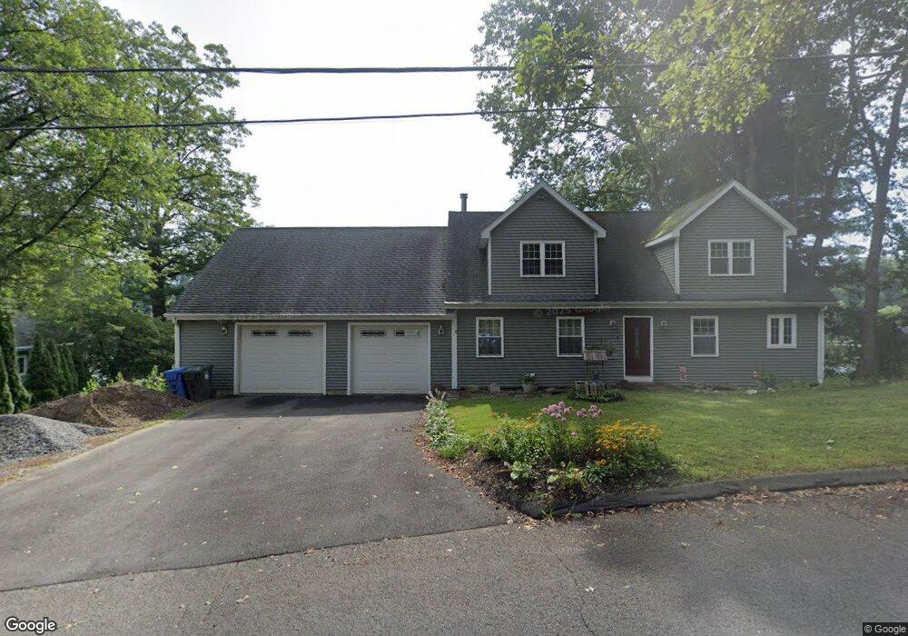
6 Westside Blvd Burlington, CT 06013
Estimated Value: $370,000 - $540,433
3
Beds
2
Baths
2,448
Sq Ft
$182/Sq Ft
Est. Value
About This Home
This home is located at 6 Westside Blvd, Burlington, CT 06013 and is currently estimated at $444,358, approximately $181 per square foot. 6 Westside Blvd is a home located in Hartford County with nearby schools including Lake Garda Elementary School, Har-Bur Middle School, and Lewis S. Mills High School.
Ownership History
Date
Name
Owned For
Owner Type
Purchase Details
Closed on
Aug 31, 2004
Sold by
Santora Sandra J
Bought by
Burns Colleen M and Brady Peter
Current Estimated Value
Home Financials for this Owner
Home Financials are based on the most recent Mortgage that was taken out on this home.
Original Mortgage
$183,000
Interest Rate
5.12%
Create a Home Valuation Report for This Property
The Home Valuation Report is an in-depth analysis detailing your home's value as well as a comparison with similar homes in the area
Home Values in the Area
Average Home Value in this Area
Purchase History
| Date | Buyer | Sale Price | Title Company |
|---|---|---|---|
| Burns Colleen M | $198,000 | -- | |
| Burns Colleen M | $198,000 | -- |
Source: Public Records
Mortgage History
| Date | Status | Borrower | Loan Amount |
|---|---|---|---|
| Open | Burns Colleen M | $337,600 | |
| Closed | Burns Colleen M | $204,517 | |
| Closed | Burns Colleen M | $15,000 | |
| Closed | Burns Colleen M | $183,000 |
Source: Public Records
Tax History
| Year | Tax Paid | Tax Assessment Tax Assessment Total Assessment is a certain percentage of the fair market value that is determined by local assessors to be the total taxable value of land and additions on the property. | Land | Improvement |
|---|---|---|---|---|
| 2025 | $8,280 | $311,290 | $63,700 | $247,590 |
| 2024 | $8,062 | $311,290 | $63,700 | $247,590 |
| 2023 | $7,204 | $223,730 | $70,780 | $152,950 |
| 2022 | $7,316 | $223,730 | $70,780 | $152,950 |
| 2021 | $7,473 | $223,730 | $70,780 | $152,950 |
| 2020 | $7,451 | $223,750 | $70,800 | $152,950 |
| 2019 | $7,383 | $223,730 | $70,780 | $152,950 |
| 2018 | $5,547 | $170,670 | $70,780 | $99,890 |
| 2017 | $5,461 | $170,670 | $70,780 | $99,890 |
| 2016 | $5,393 | $170,670 | $70,780 | $99,890 |
| 2015 | $5,308 | $170,670 | $70,780 | $99,890 |
| 2014 | $5,094 | $170,670 | $70,780 | $99,890 |
Source: Public Records
Map
Nearby Homes
- 12 Woodside St
- 16 Strong St
- 50 Woodhaven Dr
- 61 Litchfield Rd
- 26 George Washington Turnpike
- 8 Old Field Rd
- 24 Green Woods Ln
- 456 Plainville Ave
- 19 Village View Ln
- 8 Gateshead Way
- 10 Stone Ridge Crossing
- 52 Wood Creek Rd
- 1 Burlington Rd
- 60 Wildcat Rd
- 39 Jerome Ave
- 42 Keene Place
- 84 Glen Eagle Dr
- 419 Jerome Ave
- 8919 Taine Mountain Rd
- 104 Driftwood Rd
- 12 Westside Blvd
- 12 Westside Blvd Unit (WATERFR
- 8 Westside Blvd
- 4 Westside Blvd
- A W Ledge Rd
- 5 Westside Blvd
- 110 Monce Rd
- 16 Westside Blvd
- 106 Monce Rd
- 23 Westside Blvd
- 0 Westside Blvd Unit P983447
- 0 Westside Blvd Unit 170357518
- 2 Westside Blvd
- 102 Monce Rd
- 20 Westside Blvd
- 98 Monce Rd
- 132 Monce Rd
- 128 Monce Rd
- 29 Westside Blvd
- 30 Westside Blvd
Your Personal Tour Guide
Ask me questions while you tour the home.