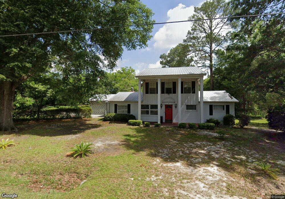
6 Woodrow Cir Statesboro, GA 30458
Estimated Value: $215,000 - $249,000
4
Beds
2
Baths
2,525
Sq Ft
$93/Sq Ft
Est. Value
About This Home
This home is located at 6 Woodrow Cir, Statesboro, GA 30458 and is currently estimated at $235,880, approximately $93 per square foot. 6 Woodrow Cir is a home located in Bulloch County with nearby schools including Statesboro High School, Mill Creek Elementary School, and Langston Chapel Middle School.
Ownership History
Date
Name
Owned For
Owner Type
Purchase Details
Closed on
Mar 27, 2008
Sold by
Not Provided
Bought by
Harding Tiffany Lynn and Harding Jonathan
Current Estimated Value
Purchase Details
Closed on
Sep 6, 2007
Sold by
Not Provided
Bought by
Harding Tiffany Lynn and Harding Jonathan
Home Financials for this Owner
Home Financials are based on the most recent Mortgage that was taken out on this home.
Original Mortgage
$80,000
Interest Rate
6.55%
Mortgage Type
New Conventional
Purchase Details
Closed on
May 1, 1991
Bought by
Blount Wesley
Create a Home Valuation Report for This Property
The Home Valuation Report is an in-depth analysis detailing your home's value as well as a comparison with similar homes in the area
Home Values in the Area
Average Home Value in this Area
Purchase History
| Date | Buyer | Sale Price | Title Company |
|---|---|---|---|
| Harding Tiffany Lynn | -- | -- | |
| Harding Tiffany Lynn | -- | -- | |
| Harding Tiffany Lynn | $100,000 | -- | |
| Blount Wesley | -- | -- |
Source: Public Records
Mortgage History
| Date | Status | Borrower | Loan Amount |
|---|---|---|---|
| Previous Owner | Harding Tiffany Lynn | $80,000 |
Source: Public Records
Tax History Compared to Growth
Tax History
| Year | Tax Paid | Tax Assessment Tax Assessment Total Assessment is a certain percentage of the fair market value that is determined by local assessors to be the total taxable value of land and additions on the property. | Land | Improvement |
|---|---|---|---|---|
| 2024 | $1,841 | $67,180 | $8,040 | $59,140 |
| 2023 | $1,310 | $61,432 | $8,160 | $53,272 |
| 2022 | $1,043 | $53,195 | $8,160 | $45,035 |
| 2021 | $935 | $46,374 | $8,160 | $38,214 |
| 2020 | $917 | $44,185 | $8,160 | $36,025 |
| 2019 | $929 | $44,509 | $8,160 | $36,349 |
| 2018 | $844 | $38,772 | $8,160 | $30,612 |
| 2017 | $819 | $37,184 | $8,160 | $29,024 |
| 2016 | $811 | $35,914 | $8,160 | $27,754 |
| 2015 | $792 | $34,892 | $8,160 | $26,732 |
| 2014 | $727 | $34,892 | $8,160 | $26,732 |
Source: Public Records
Map
Nearby Homes
- 6.24 ACRES E Olliff St
- LOT 21 Oak Hill Dr
- 0 Oak St Unit OAK ST/ LOT 2
- 316 E Main St
- 17 E Parrish St
- 9 Broad St
- 0 Highway 67 Unit 10541885
- 318 N Main St
- 328 N Main St
- 118 Lee St
- 118 Pin Oak Ln Unit 47
- 0 Green Ridge Ct Unit 40 8990863
- 0 Green Ridge Ct Unit SA344501
- 7 E Moore St
- 118 Roundtree St
- 11 W Moore St
- 342 Savannah Ave
- 405 N Main St
- 112 Stratford St
- 460 Martin Luther King jr Dr
- 8 Woodrow Cir
- 110 Woodrow Cir
- 112 Woodrow Cir
- 104 Woodrow Cir
- 511 Woodrow Ave
- N N Zetterower Ave Unit 7A
- N N Zetterower Ave Unit 9D
- N N Zetterower Ave
- 20635 U S 80
- 21201 U S 80
- 83606 U S 80
- 515 Woodrow Ave
- 56 Zetterower Ave
- 4 Groover Ln
- E E Olliff St Unit 5
- E E Olliff St Unit 4
- E E Olliff St Unit 1
- E E Olliff St Unit 2
- E E Olliff St Unit 3
- E E Olliff St