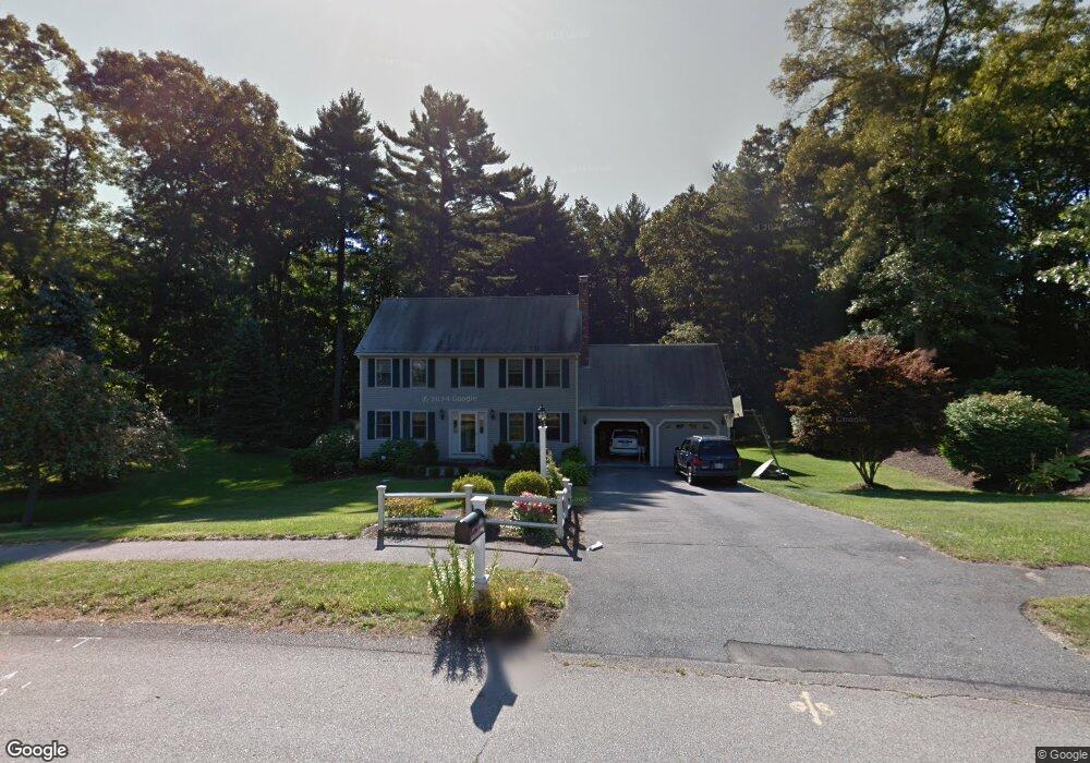
60 Caesar Chelor Dr Wrentham, MA 02093
Estimated Value: $802,089 - $984,000
4
Beds
3
Baths
3,058
Sq Ft
$292/Sq Ft
Est. Value
About This Home
This home is located at 60 Caesar Chelor Dr, Wrentham, MA 02093 and is currently estimated at $893,022, approximately $292 per square foot. 60 Caesar Chelor Dr is a home located in Norfolk County with nearby schools including Delaney Elementary School and Charles E Roderick.
Ownership History
Date
Name
Owned For
Owner Type
Purchase Details
Closed on
Apr 28, 2010
Sold by
Porter Dwight S and Porter Amy C
Bought by
Perry Edward and Perry Lisa
Current Estimated Value
Home Financials for this Owner
Home Financials are based on the most recent Mortgage that was taken out on this home.
Original Mortgage
$300,000
Outstanding Balance
$198,933
Interest Rate
4.99%
Mortgage Type
Purchase Money Mortgage
Estimated Equity
$694,089
Purchase Details
Closed on
Nov 1, 2000
Sold by
Gomes Russell W and Gomes Mary K
Bought by
Porter Dwight S and Porter Amy C
Purchase Details
Closed on
Dec 18, 1992
Sold by
Diplacido Dev Corp
Bought by
Gomes Russell W and Gomes Mary K
Create a Home Valuation Report for This Property
The Home Valuation Report is an in-depth analysis detailing your home's value as well as a comparison with similar homes in the area
Purchase History
| Date | Buyer | Sale Price | Title Company |
|---|---|---|---|
| Perry Edward | $480,000 | -- | |
| Porter Dwight S | $315,500 | -- | |
| Gomes Russell W | $183,830 | -- |
Source: Public Records
Mortgage History
| Date | Status | Borrower | Loan Amount |
|---|---|---|---|
| Open | Gomes Russell W | $25,000 | |
| Open | Perry Edward | $300,000 | |
| Previous Owner | Gomes Russell W | $75,000 | |
| Previous Owner | Gomes Russell W | $324,000 |
Source: Public Records
Tax History
| Year | Tax Paid | Tax Assessment Tax Assessment Total Assessment is a certain percentage of the fair market value that is determined by local assessors to be the total taxable value of land and additions on the property. | Land | Improvement |
|---|---|---|---|---|
| 2025 | $8,172 | $705,100 | $327,100 | $378,000 |
| 2024 | $7,967 | $663,900 | $327,100 | $336,800 |
| 2023 | $7,805 | $618,500 | $297,400 | $321,100 |
| 2022 | $7,398 | $541,200 | $270,500 | $270,700 |
| 2021 | $7,311 | $519,600 | $270,500 | $249,100 |
| 2020 | $7,024 | $492,900 | $222,400 | $270,500 |
| 2019 | $6,787 | $480,700 | $222,400 | $258,300 |
| 2018 | $6,691 | $469,900 | $222,500 | $247,400 |
| 2017 | $6,582 | $461,900 | $218,200 | $243,700 |
| 2016 | $6,440 | $451,000 | $211,900 | $239,100 |
| 2015 | $6,322 | $422,000 | $203,700 | $218,300 |
| 2014 | $5,825 | $380,500 | $167,900 | $212,600 |
Source: Public Records
Map
Nearby Homes
- 10 Nature View Dr
- 15 Nature View Dr
- 2 Earle Stewart Ln
- 3 Earle Stewart Ln
- 12 Earle Stewart Ln
- 10 Earle Stewart Ln Unit Lot 5
- 500 Franklin St
- 287 Park St
- 50 Reed Fulton Ave Unit Lot 61
- 246 Forest Grove Ave
- 45 Joshua Rd
- 576 Dedham St
- 11 Weber Farm Rd Unit 11
- 8 Weber Farm Rd Unit 8
- 0 W Birch Rd
- 30 Weber Farm Rd Unit 30
- 483 Thurston St
- 8 Ridgefield Rd
- 440 Chestnut St
- 75 Jordan Rd
- 50 Caesar Chelor Dr
- 70 Caesar Chelor Dr
- 85 Caesar Chelor Dr
- 75 Caesar Chelor Dr
- 40 Caesar Chelor Dr
- 65 Caesar Chelor Dr
- 80 Caesar Chelor Dr
- 95 Caesar Chelor Dr
- 26 William Galvin Way Unit 26
- 26 William Galvin Way Unit 3
- 26 William Galvin Way
- 22 William Galvin Way
- 22 William Galvin Way Unit 2
- 26 William Galvin Way
- 30 Caesar Chelor Dr
- 55 Caesar Chelor Dr
- 130 Lakeside Ave
- 132 Lakeside Ave
- 134 Lakeside Ave
- 105 Caesar Chelor Dr
Your Personal Tour Guide
Ask me questions while you tour the home.