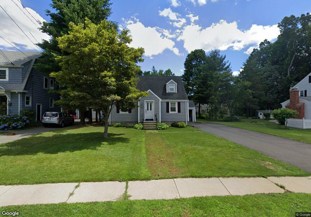
60 Clearfield Rd Wethersfield, CT 06109
Estimated Value: $378,000 - $437,000
3
Beds
3
Baths
1,376
Sq Ft
$299/Sq Ft
Est. Value
About This Home
This home is located at 60 Clearfield Rd, Wethersfield, CT 06109 and is currently estimated at $411,074, approximately $298 per square foot. 60 Clearfield Rd is a home located in Hartford County with nearby schools including Emerson-Williams School, Silas Deane Middle School, and Wethersfield High School.
Ownership History
Date
Name
Owned For
Owner Type
Purchase Details
Closed on
Jul 5, 2007
Sold by
Bursell Benjamin and Rice Kyla M
Bought by
Gaunreau Brian M
Current Estimated Value
Purchase Details
Closed on
Jun 21, 2004
Sold by
Rosen Mary Louise
Bought by
Rice Kyla M and Bursell Benjamin
Purchase Details
Closed on
Nov 12, 2003
Sold by
Branon Theodore R and Branon Susan
Bought by
Rosen Mary Louise
Purchase Details
Closed on
Jun 14, 1999
Sold by
Coppa Lawrence R
Bought by
Branon Theodore R
Purchase Details
Closed on
Aug 15, 1991
Sold by
Cappa Richard B and Cappa Anita B
Bought by
Cappa Lawrence R
Create a Home Valuation Report for This Property
The Home Valuation Report is an in-depth analysis detailing your home's value as well as a comparison with similar homes in the area
Home Values in the Area
Average Home Value in this Area
Purchase History
| Date | Buyer | Sale Price | Title Company |
|---|---|---|---|
| Gaunreau Brian M | $275,000 | -- | |
| Rice Kyla M | $260,000 | -- | |
| Rosen Mary Louise | $247,000 | -- | |
| Branon Theodore R | $147,000 | -- | |
| Cappa Lawrence R | $145,000 | -- |
Source: Public Records
Mortgage History
| Date | Status | Borrower | Loan Amount |
|---|---|---|---|
| Closed | Cappa Lawrence R | $60,000 | |
| Closed | Cappa Lawrence R | $128,000 |
Source: Public Records
Tax History
| Year | Tax Paid | Tax Assessment Tax Assessment Total Assessment is a certain percentage of the fair market value that is determined by local assessors to be the total taxable value of land and additions on the property. | Land | Improvement |
|---|---|---|---|---|
| 2025 | $10,264 | $249,010 | $94,740 | $154,270 |
| 2024 | $6,850 | $158,500 | $74,230 | $84,270 |
| 2023 | $6,622 | $158,500 | $74,230 | $84,270 |
| 2022 | $6,511 | $158,500 | $74,230 | $84,270 |
| 2021 | $6,446 | $158,500 | $74,230 | $84,270 |
| 2020 | $6,449 | $158,500 | $74,230 | $84,270 |
| 2019 | $6,457 | $158,500 | $74,230 | $84,270 |
| 2018 | $6,769 | $166,000 | $71,300 | $94,700 |
| 2017 | $6,602 | $166,000 | $71,300 | $94,700 |
| 2016 | $6,398 | $166,000 | $71,300 | $94,700 |
| 2015 | $6,340 | $166,000 | $71,300 | $94,700 |
| 2014 | $6,099 | $166,000 | $71,300 | $94,700 |
Source: Public Records
Map
Nearby Homes
- 137 Dale Rd
- 38 Wheeler Rd
- 89 Merriman Rd
- 455 Brimfield Rd
- 119 Coleman Rd
- 108 Chamberlain Rd
- 35 Stillwold Dr
- 116 Wells Farm Dr
- 91 Somerset St
- 195 Middletown Ave
- 87 Somerset St
- 104 Willow St
- 0 Collier Rd
- 101 Collier Rd
- 20 Forest Dr
- 1 Fernwood St
- 7 Barrington Dr Unit C
- 317 Garden St Unit 319
- 273 Forest Dr
- 5 Robeth Ln
- 54 Clearfield Rd
- 68 Clearfield Rd
- 275 Brimfield Rd
- 48 Clearfield Rd
- 283 Brimfield Rd
- 267 Brimfield Rd
- 78 Clearfield Rd
- 65 Clearfield Rd
- 61 Clearfield Rd
- 67 Clearfield Rd
- 287 Brimfield Rd
- 57 Clearfield Rd
- 263 Brimfield Rd
- 73 Clearfield Rd
- 49 Clearfield Rd
- 77 Clearfield Rd
- 40 Clearfield Rd
- 69 Dale Rd
- 75 Dale Rd
- 255 Brimfield Rd
Your Personal Tour Guide
Ask me questions while you tour the home.