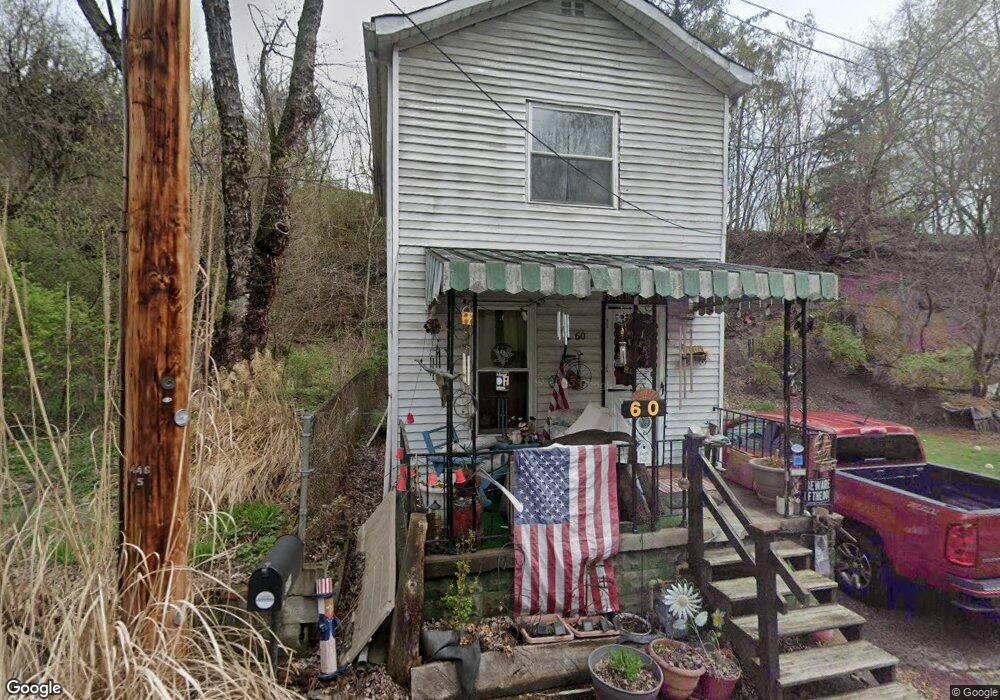
60 F St Mc Kees Rocks, PA 15136
Stowe Township NeighborhoodEstimated Value: $58,148 - $87,000
2
Beds
1
Bath
735
Sq Ft
$98/Sq Ft
Est. Value
About This Home
This home is located at 60 F St, Mc Kees Rocks, PA 15136 and is currently estimated at $72,287, approximately $98 per square foot. 60 F St is a home located in Allegheny County with nearby schools including Sto-Rox Upper Elementary School, Sto-Rox Primary Center, and Sto-Rox Junior/Senior High School.
Ownership History
Date
Name
Owned For
Owner Type
Purchase Details
Closed on
Sep 12, 2025
Sold by
Ozga Thomas R
Bought by
Robinson Megan I By Aif and Dingman
Current Estimated Value
Purchase Details
Closed on
Aug 6, 2013
Sold by
Rugh David
Bought by
Ozga Thomas R
Home Financials for this Owner
Home Financials are based on the most recent Mortgage that was taken out on this home.
Original Mortgage
$250,000
Interest Rate
4.45%
Mortgage Type
New Conventional
Purchase Details
Closed on
Jan 22, 2010
Sold by
Abatta Janet and Abatta Samuel J
Bought by
Rugh David and Yaweh Properties L L C
Purchase Details
Closed on
Apr 10, 1999
Sold by
Sicilia Frank and Sicilia Adeline
Bought by
The Frank P & Adeline C Sicilia Revocabl
Purchase Details
Closed on
Jan 1, 1900
Create a Home Valuation Report for This Property
The Home Valuation Report is an in-depth analysis detailing your home's value as well as a comparison with similar homes in the area
Home Values in the Area
Average Home Value in this Area
Purchase History
| Date | Buyer | Sale Price | Title Company |
|---|---|---|---|
| Robinson Megan I By Aif | $35,000 | -- | |
| Ozga Thomas R | $12,000 | -- | |
| Rugh David | $10,000 | -- | |
| The Frank P & Adeline C Sicilia Revocabl | -- | -- | |
| -- | -- | -- |
Source: Public Records
Mortgage History
| Date | Status | Borrower | Loan Amount |
|---|---|---|---|
| Previous Owner | Ozga Thomas R | $250,000 |
Source: Public Records
Tax History Compared to Growth
Tax History
| Year | Tax Paid | Tax Assessment Tax Assessment Total Assessment is a certain percentage of the fair market value that is determined by local assessors to be the total taxable value of land and additions on the property. | Land | Improvement |
|---|---|---|---|---|
| 2025 | $864 | $20,000 | $9,300 | $10,700 |
| 2024 | $864 | $20,000 | $9,300 | $10,700 |
| 2023 | $831 | $20,000 | $9,300 | $10,700 |
| 2022 | $804 | $20,000 | $9,300 | $10,700 |
| 2021 | $786 | $20,000 | $9,300 | $10,700 |
| 2020 | $786 | $20,000 | $9,300 | $10,700 |
| 2019 | $786 | $20,000 | $9,300 | $10,700 |
| 2018 | $95 | $20,000 | $9,300 | $10,700 |
| 2017 | $768 | $20,000 | $9,300 | $10,700 |
| 2016 | $95 | $20,000 | $9,300 | $10,700 |
| 2015 | $95 | $20,000 | $9,300 | $10,700 |
| 2014 | $768 | $20,000 | $9,300 | $10,700 |
Source: Public Records
Map
Nearby Homes
- 82 Harlem Ave
- 125 Frazier Ave
- 837 Benwood Ave
- 45 Harlem Ave
- 813 8th St
- 19 Shaw Ave
- 22 Harlem Ave
- 810 Woodward Ave
- 815 10th St
- 813 10th St
- 802 10th St
- 705 Broadway Ave
- 124 Pleasant Ridge Rd
- 810 10th St
- 815 Broadway Ave
- 634 Broadway Ave
- 620 Broadway Ave
- 705 Russellwood Ave
- 713 Russellwood Ave
- 27 Highland Ave