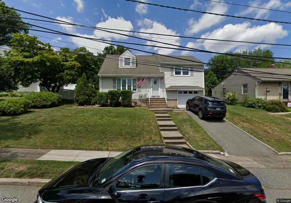
60 Martindale Rd Clifton, NJ 07013
Maple Valley NeighborhoodEstimated Value: $669,000 - $751,000
--
Bed
--
Bath
1,512
Sq Ft
$465/Sq Ft
Est. Value
About This Home
This home is located at 60 Martindale Rd, Clifton, NJ 07013 and is currently estimated at $703,189, approximately $465 per square foot. 60 Martindale Rd is a home located in Passaic County with nearby schools including Clifton High School, The Magical Palace of Knowledge, and Saint Philip the Apostle Preparatory School.
Ownership History
Date
Name
Owned For
Owner Type
Purchase Details
Closed on
Jun 30, 2011
Sold by
Wittmann Robert S and Wittmann Barbara A
Bought by
Serafini Nicholas R and Serafini Patricia
Current Estimated Value
Home Financials for this Owner
Home Financials are based on the most recent Mortgage that was taken out on this home.
Original Mortgage
$355,747
Outstanding Balance
$247,498
Interest Rate
4.75%
Mortgage Type
FHA
Estimated Equity
$455,691
Create a Home Valuation Report for This Property
The Home Valuation Report is an in-depth analysis detailing your home's value as well as a comparison with similar homes in the area
Home Values in the Area
Average Home Value in this Area
Purchase History
| Date | Buyer | Sale Price | Title Company |
|---|---|---|---|
| Serafini Nicholas R | $365,000 | -- |
Source: Public Records
Mortgage History
| Date | Status | Borrower | Loan Amount |
|---|---|---|---|
| Open | Serafini Nicholas R | $355,747 |
Source: Public Records
Tax History Compared to Growth
Tax History
| Year | Tax Paid | Tax Assessment Tax Assessment Total Assessment is a certain percentage of the fair market value that is determined by local assessors to be the total taxable value of land and additions on the property. | Land | Improvement |
|---|---|---|---|---|
| 2025 | $11,029 | $185,800 | $90,600 | $95,200 |
| 2024 | $10,765 | $185,800 | $90,600 | $95,200 |
| 2022 | $10,609 | $185,800 | $90,600 | $95,200 |
| 2021 | $10,173 | $185,800 | $90,600 | $95,200 |
| 2020 | $10,206 | $185,800 | $90,600 | $95,200 |
| 2019 | $10,134 | $185,800 | $90,600 | $95,200 |
| 2018 | $10,076 | $185,800 | $90,600 | $95,200 |
| 2017 | $9,966 | $185,800 | $90,600 | $95,200 |
| 2016 | $9,684 | $184,100 | $90,600 | $93,500 |
| 2015 | $9,590 | $184,100 | $90,600 | $93,500 |
| 2014 | $9,393 | $184,100 | $90,600 | $93,500 |
Source: Public Records
Map
Nearby Homes
- 678 Broad St Unit A3
- 678 Broad St Unit A003
- 25 Karen Dr
- 1371 Van Houten Ave Unit 4
- 124 Thanksgiving Ln
- 159 George Russell Way Unit 311
- 176 Winchester Ct
- 375 Colfax Ave
- 7 Barrister St Unit 170
- 1110 Wickham Terrace
- 6102 Harcourt Rd Unit 519
- 6102 Harcourt Rd Unit 102
- 8205 Harcourt Rd
- 27 Coppola Ct
- 7303 Ravenscroft Rd Unit 570
- 7303 Ravenscroft Rd
- 35 Coppola Ct
- 23 Carrington Place Unit 57
- 23 Carrington Place
- 83 Larkspur Ln