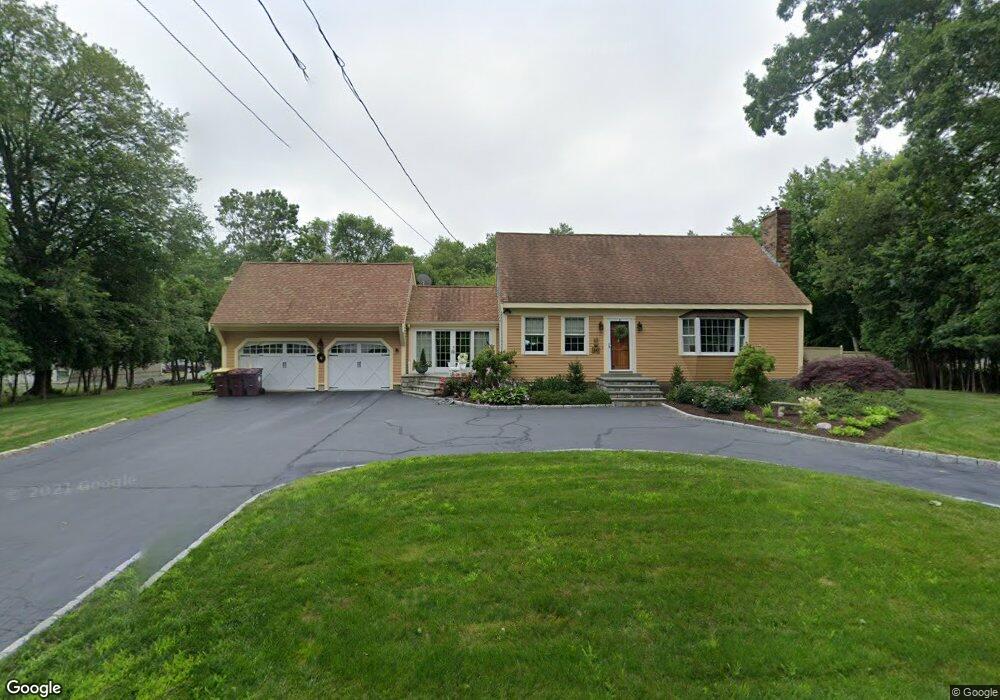
60 Mattapoisett Rd Acushnet, MA 02743
Estimated Value: $562,000 - $656,000
3
Beds
2
Baths
1,778
Sq Ft
$338/Sq Ft
Est. Value
About This Home
This home is located at 60 Mattapoisett Rd, Acushnet, MA 02743 and is currently estimated at $600,650, approximately $337 per square foot. 60 Mattapoisett Rd is a home located in Bristol County with nearby schools including Acushnet Elementary School, Albert F Ford Middle School, and St Francis Xavier Elementary School.
Ownership History
Date
Name
Owned For
Owner Type
Purchase Details
Closed on
Nov 16, 1977
Bought by
George C Renaud Ret
Current Estimated Value
Create a Home Valuation Report for This Property
The Home Valuation Report is an in-depth analysis detailing your home's value as well as a comparison with similar homes in the area
Home Values in the Area
Average Home Value in this Area
Purchase History
| Date | Buyer | Sale Price | Title Company |
|---|---|---|---|
| George C Renaud Ret | -- | -- |
Source: Public Records
Mortgage History
| Date | Status | Borrower | Loan Amount |
|---|---|---|---|
| Open | George C Renaud Ret | $55,000 | |
| Closed | George C Renaud Ret | $65,000 | |
| Closed | George C Renaud Ret | $50,000 | |
| Closed | George C Renaud Ret | $35,000 |
Source: Public Records
Tax History Compared to Growth
Tax History
| Year | Tax Paid | Tax Assessment Tax Assessment Total Assessment is a certain percentage of the fair market value that is determined by local assessors to be the total taxable value of land and additions on the property. | Land | Improvement |
|---|---|---|---|---|
| 2025 | $5,435 | $503,700 | $164,300 | $339,400 |
| 2024 | $5,208 | $456,400 | $155,300 | $301,100 |
| 2023 | $5,160 | $430,000 | $134,400 | $295,600 |
| 2022 | $5,170 | $389,600 | $128,400 | $261,200 |
| 2021 | $4,835 | $349,600 | $128,400 | $221,200 |
| 2020 | $4,873 | $349,600 | $128,400 | $221,200 |
| 2019 | $4,779 | $337,000 | $131,400 | $205,600 |
| 2018 | $193 | $323,000 | $131,400 | $191,600 |
| 2017 | $4,534 | $314,000 | $131,400 | $182,600 |
| 2016 | $4,480 | $308,300 | $122,500 | $185,800 |
| 2015 | $4,150 | $290,600 | $122,500 | $168,100 |
Source: Public Records
Map
Nearby Homes
- 66 Mattapoisett Rd
- 54 Mattapoisett Rd
- 63 Mattapoisett Rd
- 55 Mattapoisett Rd
- 72 Mattapoisett Rd
- 67 Mattapoisett Rd
- 78 Mattapoisett Rd
- 45 Mattapoisett Rd
- 45 Mattapoisett Rd
- 47 Mattapoisett Rd
- 75 Mattapoisett Rd
- 43 Mattapoisett Rd
- 84 Mattapoisett Rd
- 40 Mattapoisett Rd
- 41 Mattapoisett Rd
- 115 Mattapoisett Rd
- 38 Mattapoisett Rd
- 135 Mattapoisett Rd
- 36 Mattapoisett Rd
- 37 Mattapoisett Rd