D
Seller's Agent in 2025
Daniel Robertson
Stoudt Realty
(603) 801-8822
1 in this area
10 Total Sales


Estimated Value: $496,000 - $513,082
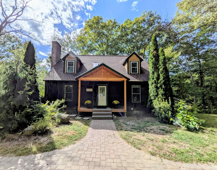
Escape to a private New Boston sanctuary on 3.98 acres with tranquil Piscataquog River frontage. This unique 5-bedroom home offers a perfect blend of comfort and natural beauty, featuring an open-concept living area and a cozy fireplace. Enjoy mornings on the spacious private deck with beautiful views of wildlife.The property includes a charming outdoor pony barn with water access. Located just a short drive from New Boston Central School, the central village, as well as the New Boston Rail Trail. Don't miss this one-of-a-kind New England gem. OPEN HOUSE Saturday, September 27th 11AM - 1PM.
Last Agent to Sell the Property
Stoudt Realty License #069546 Listed on: 09/21/2025
| Date | Buyer | Sale Price | Title Company |
|---|---|---|---|
| Rizzitano Victoria | $500,000 | -- | |
| Rizzitano Victoria | $500,000 | -- | |
| Niles Richard B | $235,000 | -- | |
| Marshburn Erinn D | $270,000 | -- |
| Date | Status | Borrower | Loan Amount |
|---|---|---|---|
| Open | Rizzitano Victoria | $475,000 | |
| Closed | Rizzitano Victoria | $475,000 | |
| Previous Owner | Marshburn Erinn D | $225,482 | |
| Previous Owner | Marshburn Erinn D | $216,000 |
| Date | Event | Price | List to Sale | Price per Sq Ft |
|---|---|---|---|---|
| 11/10/2025 11/10/25 | Sold | $500,000 | -4.8% | $274 / Sq Ft |
| 09/21/2025 09/21/25 | For Sale | $525,000 | -- | $288 / Sq Ft |
| Year | Tax Paid | Tax Assessment Tax Assessment Total Assessment is a certain percentage of the fair market value that is determined by local assessors to be the total taxable value of land and additions on the property. | Land | Improvement |
|---|---|---|---|---|
| 2025 | $8,086 | $341,600 | $168,900 | $172,700 |
| 2024 | $8,127 | $341,600 | $168,900 | $172,700 |
| 2023 | $6,952 | $341,600 | $168,900 | $172,700 |
| 2022 | $6,552 | $341,600 | $168,900 | $172,700 |
| 2021 | $6,320 | $341,600 | $168,900 | $172,700 |
| 2020 | $5,948 | $246,900 | $110,000 | $136,900 |
| 2019 | $6,185 | $246,900 | $110,000 | $136,900 |
| 2018 | $5,894 | $246,900 | $110,000 | $136,900 |
| 2017 | $6,012 | $246,900 | $110,000 | $136,900 |
| 2016 | $5,765 | $246,900 | $110,000 | $136,900 |
| 2015 | $6,085 | $227,800 | $102,800 | $125,000 |
| 2014 | $5,798 | $227,800 | $102,800 | $125,000 |
| 2013 | $5,522 | $227,800 | $102,800 | $125,000 |
D
Seller's Agent in 2025
Daniel Robertson
Stoudt Realty
(603) 801-8822
1 in this area
10 Total Sales

Buyer's Agent in 2025
Tami Harris
RE/MAX
(603) 294-2025
3 in this area
18 Total Sales
Source: PrimeMLS
MLS Number: 5062340
APN: NBOS-000004-000002-000012
Disclaimer: Certain information contained herein is derived from information provided by parties other than Homes.com. All information provided is deemed reliable, but is not guaranteed to be accurate and should be independently verified.
![]() Copyright 2026 PrimeMLS, Inc. All rights reserved. This information is deemed reliable, but not guaranteed. The data relating to real estate displayed on this display comes in part from the IDX Program of PrimeMLS. The information being provided is for consumers’ personal, non-commercial use and may not be used for any purpose other than to identify prospective properties consumers may be interested in purchasing.
Copyright 2026 PrimeMLS, Inc. All rights reserved. This information is deemed reliable, but not guaranteed. The data relating to real estate displayed on this display comes in part from the IDX Program of PrimeMLS. The information being provided is for consumers’ personal, non-commercial use and may not be used for any purpose other than to identify prospective properties consumers may be interested in purchasing.
Ask me questions while you tour the home.