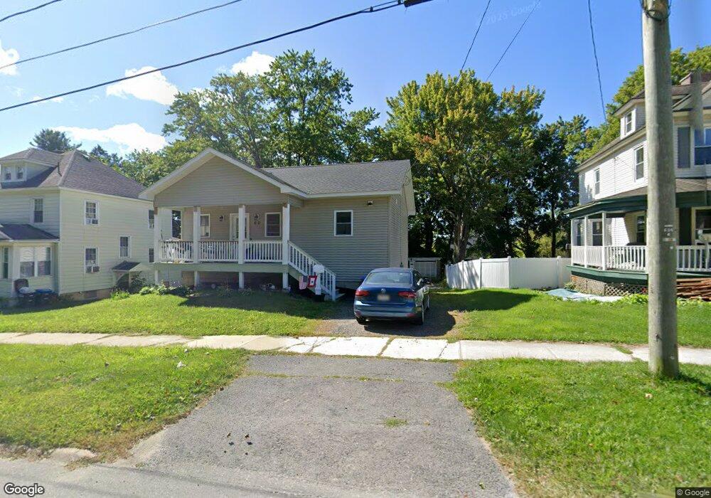
60 Springside Ave Pittsfield, MA 01201
Estimated Value: $251,000 - $342,030
3
Beds
3
Baths
1,664
Sq Ft
$169/Sq Ft
Est. Value
About This Home
This home is located at 60 Springside Ave, Pittsfield, MA 01201 and is currently estimated at $282,008, approximately $169 per square foot. 60 Springside Ave is a home located in Berkshire County with nearby schools including Morningside Community School, John T. Reid Middle School, and Taconic High School.
Ownership History
Date
Name
Owned For
Owner Type
Purchase Details
Closed on
Oct 25, 2019
Sold by
White Mark A
Bought by
Mark A White Ft and White
Current Estimated Value
Purchase Details
Closed on
Nov 16, 2018
Sold by
White Mark A and White
Bought by
White Mark A and White Eileen
Create a Home Valuation Report for This Property
The Home Valuation Report is an in-depth analysis detailing your home's value as well as a comparison with similar homes in the area
Home Values in the Area
Average Home Value in this Area
Purchase History
| Date | Buyer | Sale Price | Title Company |
|---|---|---|---|
| Mark A White Ft | -- | -- | |
| Mark A White Ft | -- | -- | |
| Mark A White Ft | -- | -- | |
| White Mark A | -- | -- | |
| White Mark A | -- | -- | |
| White Mark A | -- | -- | |
| White Mark A | -- | -- | |
| White Mark A | -- | -- |
Source: Public Records
Tax History Compared to Growth
Tax History
| Year | Tax Paid | Tax Assessment Tax Assessment Total Assessment is a certain percentage of the fair market value that is determined by local assessors to be the total taxable value of land and additions on the property. | Land | Improvement |
|---|---|---|---|---|
| 2025 | $4,851 | $270,400 | $33,500 | $236,900 |
| 2024 | $4,358 | $236,200 | $33,500 | $202,700 |
| 2023 | $4,007 | $218,700 | $33,500 | $185,200 |
| 2022 | $2,752 | $148,300 | $33,500 | $114,800 |
| 2021 | $2,657 | $138,000 | $33,500 | $104,500 |
| 2020 | $2,653 | $134,600 | $33,500 | $101,100 |
| 2019 | $2,511 | $129,300 | $31,600 | $97,700 |
| 2018 | $3,077 | $126,000 | $31,600 | $94,400 |
| 2017 | $2,503 | $127,500 | $36,400 | $91,100 |
| 2016 | $2,394 | $127,600 | $36,400 | $91,200 |
| 2015 | $2,304 | $127,600 | $36,400 | $91,200 |
Source: Public Records
Map
Nearby Homes
- 26 Springside Ave
- 9 Myrtle St
- 29 Glenwood Ave
- 24 Glenwood Ave
- 68 Orchard St
- 74 Briggs Ave
- 52 Brown St
- 48 Brown St
- 131 Lenox Ave
- 19 Richmond Ave
- 98 Lincoln St
- 71 Maplewood Ave
- 58 Seymour St
- 33 Maplewood Ave Unit 305
- 33 Maplewood Ave Unit 103
- LOT 20 Plunkett St
- 156 Draper Ave
- 185 Lenox Ave
- 242 Wahconah St
- 51 Adam St
- 64 Springside Ave
- 52 Springside Ave
- 66 Springside Ave
- 48 Springside Ave
- 27 Hull Ave
- 33 Hull Ave
- 35 Hull Ave
- 23 Hull Ave
- 42 Springside Ave
- 39 Hull Ave
- 53 Springside Ave
- 41 Hull Ave
- 17 Hull Ave
- 45 Springside Ave
- 38 Springside Ave
- 38 Springside Ave Unit 1
- 38 Springside Ave
- 41 Springside Ave
- 43 Hull Ave
- 9 Hull Ave