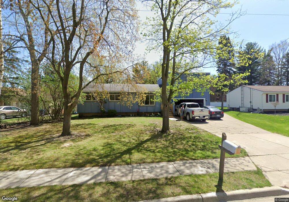
600 Cherry St Linden, MI 48451
Estimated Value: $319,002 - $358,000
4
Beds
2
Baths
1,978
Sq Ft
$168/Sq Ft
Est. Value
About This Home
This home is located at 600 Cherry St, Linden, MI 48451 and is currently estimated at $332,501, approximately $168 per square foot. 600 Cherry St is a home located in Genesee County with nearby schools including Linden Elementary School, Linden Middle School, and Linden High School.
Ownership History
Date
Name
Owned For
Owner Type
Purchase Details
Closed on
Apr 28, 2010
Sold by
Neuville Edward and Neuville Beverly
Bought by
Neuville Christopher L and Neuville Christine
Current Estimated Value
Purchase Details
Closed on
Jul 8, 2009
Sold by
Barnhart Christopher L
Bought by
Federal National Mortgage Association
Purchase Details
Closed on
Dec 12, 2006
Sold by
Va
Bought by
Barnhart Chris and Barnhart Christopher L
Purchase Details
Closed on
Jan 5, 2005
Sold by
Byron Edward E and Byron Doris J
Bought by
Mortgage Electronic Registration and Mortgage Investors Corp
Create a Home Valuation Report for This Property
The Home Valuation Report is an in-depth analysis detailing your home's value as well as a comparison with similar homes in the area
Home Values in the Area
Average Home Value in this Area
Purchase History
We collect this data history from publicly available records. To have your information removed, we recommend requesting removal directly through your county’s website.
| Date | Buyer | Sale Price | Title Company |
|---|---|---|---|
| Neuville Christopher L | -- | Cislo Title Co | |
| Federal National Mortgage Association | $96,421 | None Available | |
| Barnhart Chris | -- | Guaranty Title Company | |
| Mortgage Electronic Registration | $110,163 | -- | |
| Va | -- | Attorneys Title Agency Llc |
Source: Public Records
Tax History
| Year | Tax Paid | Tax Assessment Tax Assessment Total Assessment is a certain percentage of the fair market value that is determined by local assessors to be the total taxable value of land and additions on the property. | Land | Improvement |
|---|---|---|---|---|
| 2025 | $2,823 | $145,500 | $0 | $0 |
| 2024 | $1,673 | $132,700 | $0 | $0 |
| 2023 | $1,728 | $111,700 | $0 | $0 |
| 2022 | $2,610 | $95,800 | $0 | $0 |
| 2021 | $2,272 | $88,000 | $0 | $0 |
| 2020 | $1,575 | $81,500 | $0 | $0 |
| 2019 | $1,575 | $74,500 | $0 | $0 |
| 2018 | $2,109 | $74,500 | $0 | $0 |
| 2017 | $2,045 | $72,100 | $0 | $0 |
| 2016 | $2,056 | $66,000 | $0 | $0 |
| 2015 | $2,102 | $58,000 | $0 | $0 |
| 2012 | -- | $47,342 | $47,342 | $0 |
Source: Public Records
Map
Nearby Homes
- 214 Willow Ln
- 717 Murphy Ct
- 336 Park Ln
- 532 E Broad St
- 310 N Bridge St
- 313 Maple Dr
- 0 Ripley Rd
- 301 Lindenwood Dr
- 14238 Durant St
- 4468 Edison Blvd Unit 50
- 4457 Edison Blvd
- 4447 Edison Blvd
- 4448 Ford Ave
- 5220 Amelia Earhart Dr
- 5407 Spring Meadows Way
- 216 Canterbury Ct Unit 84
- 14270 Wright Dr
- 149 Creekwood Cir Unit 16
- 14275 Wright Dr
- 513 W Broad St
Your Personal Tour Guide
Ask me questions while you tour the home.