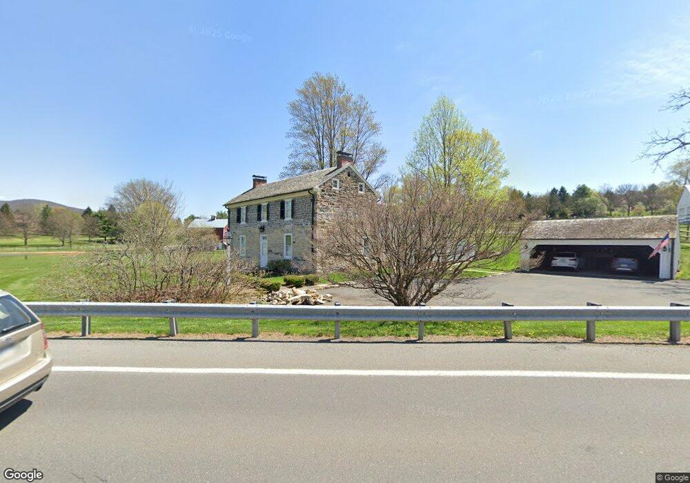
600 E Branch Rd State College, PA 16801
Estimated Value: $529,000 - $876,343
4
Beds
3
Baths
3,668
Sq Ft
$191/Sq Ft
Est. Value
About This Home
This home is located at 600 E Branch Rd, State College, PA 16801 and is currently estimated at $701,336, approximately $191 per square foot. 600 E Branch Rd is a home located in Centre County with nearby schools including Mount Nittany Elementary School, Mount Nittany Middle School, and State College Area High School.
Ownership History
Date
Name
Owned For
Owner Type
Purchase Details
Closed on
Mar 28, 2018
Sold by
Seehafer Collen Alice and Seehafer Bradlee
Bought by
Kissinger Brian F and Kissinger John G
Current Estimated Value
Purchase Details
Closed on
Jun 21, 2016
Sold by
Lee David B and G D Kissinger Testamentary Tru
Bought by
Seehafer Colleen Alice and Kissinger John G
Purchase Details
Closed on
Feb 28, 2013
Sold by
Kissinger Richard G
Bought by
Frederick J Kissinger Lp
Purchase Details
Closed on
Feb 1, 1997
Bought by
Kissinger Frederick J Co-Tr and Kissinger Kissinger
Create a Home Valuation Report for This Property
The Home Valuation Report is an in-depth analysis detailing your home's value as well as a comparison with similar homes in the area
Home Values in the Area
Average Home Value in this Area
Purchase History
| Date | Buyer | Sale Price | Title Company |
|---|---|---|---|
| Kissinger Brian F | -- | None Available | |
| Seehafer Colleen Alice | -- | None Available | |
| Frederick J Kissinger Lp | $325,500 | None Available | |
| Kissinger Frederick J Co-Tr | -- | -- |
Source: Public Records
Tax History Compared to Growth
Tax History
| Year | Tax Paid | Tax Assessment Tax Assessment Total Assessment is a certain percentage of the fair market value that is determined by local assessors to be the total taxable value of land and additions on the property. | Land | Improvement |
|---|---|---|---|---|
| 2025 | $10,136 | $187,660 | $33,900 | $153,760 |
| 2024 | $11,558 | $187,660 | $33,900 | $153,760 |
| 2023 | $11,558 | $187,660 | $33,900 | $153,760 |
| 2022 | $9,381 | $187,660 | $33,900 | $153,760 |
| 2021 | $9,381 | $187,660 | $33,900 | $153,760 |
| 2020 | $9,334 | $187,660 | $33,900 | $153,760 |
| 2019 | $8,046 | $187,660 | $33,900 | $153,760 |
| 2018 | $8,968 | $187,660 | $33,900 | $153,760 |
| 2017 | $10,643 | $187,660 | $33,900 | $153,760 |
| 2016 | -- | $156,270 | $2,510 | $153,760 |
| 2015 | -- | $156,270 | $2,510 | $153,760 |
| 2014 | -- | $156,270 | $2,510 | $153,760 |
Source: Public Records
Map
Nearby Homes
- 128 Colonial Ct Unit 8
- 1353 Sandpiper Dr
- 354 Village Heights Dr Unit 114
- 425 Windmere Dr Unit 3B
- 212 Seneca Cir
- 1209 Mayberry Ln
- 106 Wellington Dr Unit 106
- 323 Bradley Ave
- 3750 S Atherton St
- 101 Timber Ln
- 301 Goldfinch Dr
- 241 Bradley Ave
- 120 Abbott Ln Unit 10
- 130 Matilda Ave
- 899 Walnut Spring Ln
- 933 Oak Ridge Ave
- 1516 Elizabeth Rd
- 416 E Irvin Ave
- 247 E Mccormick Ave
- 1132 Old Boalsburg Rd
- 1943 Cliffside Dr
- 1949 Cliffside Dr Unit 3
- 1945 Cliffside Dr Unit 2
- 1951 Cliffside Dr Unit 4
- 1951 Cliffside Dr Unit 1
- 1951 Cliffside Dr
- 1955 Cliffside Dr
- 1957 Cliffside Dr
- 1961 Cliffside Dr
- 132 Colonial Ct
- 1963 Cliffside Dr
- 136 Colonial Ct
- 124 Colonial Ct Unit 7
- 1967 Cliffside Dr
- 140 Colonial Ct
- 105 Colonial Ct Unit 14
- 120 Colonial Ct
- 1013 Greenbriar Dr
- 1011 Greenbriar Dr
- 1969 Cliffside Dr