Estimated Value: $913,634 - $1,133,000
--
Bed
1
Bath
3,405
Sq Ft
$288/Sq Ft
Est. Value
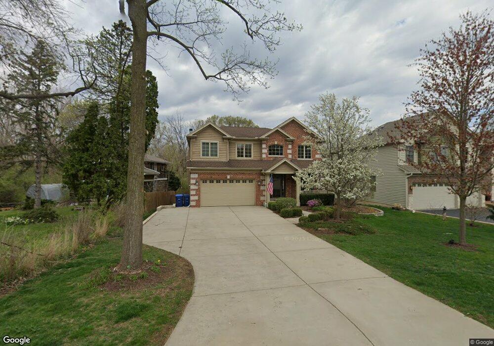
About This Home
This home is located at 600 Front St Unit A, Lisle, IL 60532 and is currently estimated at $979,659, approximately $287 per square foot. 600 Front St Unit A is a home located in DuPage County with nearby schools including Lisle Elementary School, Lisle Jr High School, and Lisle High School.
Ownership History
Date
Name
Owned For
Owner Type
Purchase Details
Closed on
Apr 17, 2008
Sold by
Desalvo Joseph
Bought by
Decoste David R and Decoste Sara J
Current Estimated Value
Home Financials for this Owner
Home Financials are based on the most recent Mortgage that was taken out on this home.
Original Mortgage
$562,500
Outstanding Balance
$349,764
Interest Rate
5.62%
Mortgage Type
Purchase Money Mortgage
Estimated Equity
$629,895
Purchase Details
Closed on
Nov 21, 2005
Sold by
Didier Development Inc
Bought by
Desalvo Joseph
Create a Home Valuation Report for This Property
The Home Valuation Report is an in-depth analysis detailing your home's value as well as a comparison with similar homes in the area
Home Values in the Area
Average Home Value in this Area
Purchase History
| Date | Buyer | Sale Price | Title Company |
|---|---|---|---|
| Decoste David R | $750,000 | Affinity Title Services Llc | |
| Desalvo Joseph | $217,000 | -- |
Source: Public Records
Mortgage History
| Date | Status | Borrower | Loan Amount |
|---|---|---|---|
| Open | Decoste David R | $562,500 |
Source: Public Records
Tax History Compared to Growth
Tax History
| Year | Tax Paid | Tax Assessment Tax Assessment Total Assessment is a certain percentage of the fair market value that is determined by local assessors to be the total taxable value of land and additions on the property. | Land | Improvement |
|---|---|---|---|---|
| 2024 | $20,636 | $293,900 | $61,228 | $232,672 |
| 2023 | $19,839 | $266,410 | $55,880 | $210,530 |
| 2022 | $18,898 | $256,410 | $53,780 | $202,630 |
| 2021 | $18,365 | $246,720 | $51,750 | $194,970 |
| 2020 | $17,611 | $242,290 | $50,820 | $191,470 |
| 2019 | $17,348 | $231,810 | $48,620 | $183,190 |
| 2018 | $16,909 | $231,810 | $48,620 | $183,190 |
| 2017 | $16,763 | $223,990 | $46,980 | $177,010 |
| 2016 | $16,393 | $215,890 | $45,280 | $170,610 |
| 2015 | $15,471 | $196,310 | $42,640 | $153,670 |
| 2014 | $14,836 | $182,530 | $40,610 | $141,920 |
| 2013 | $14,551 | $182,970 | $40,710 | $142,260 |
Source: Public Records
Map
Nearby Homes
- 4705 Elm St
- 4721 Saint Joseph Creek Rd Unit 1B
- 4721 Saint Joseph Creek Rd Unit 4A
- 4711 Saint Joseph Creek Rd Unit 4H
- 875 Mckenzie Station Dr
- 4542 Basswood Dr
- 403 Provence Ct
- 752 Rolling Dr
- 5300 Walnut Ave Unit 4D
- 1002 Ogden Ave
- 4432 Cascara Ln
- 5400 Walnut Ave Unit 214
- 5400 Walnut Ave Unit 712
- 000 Main St
- 5540 Walnut Ave Unit 4A
- 5540 Walnut Ave Unit 15B
- 573 Maple Ave
- Lots 02,03,12,13,14, Southport Ave
- 4703 Garfield Ave
- 2900 Maple Ave Unit 13C