NOT LISTED FOR SALE

600 N Haugh Ave Picayune, MS 39466

Estimated Value: $77,000 - $193,000

0.89 Acre
$143,698 Price per Acre
38,712 Sq Ft Lot

Last Sold July 24, 2023

Current estimated payment $759/month

13 Days on Market

About This Lot

As of July 2023

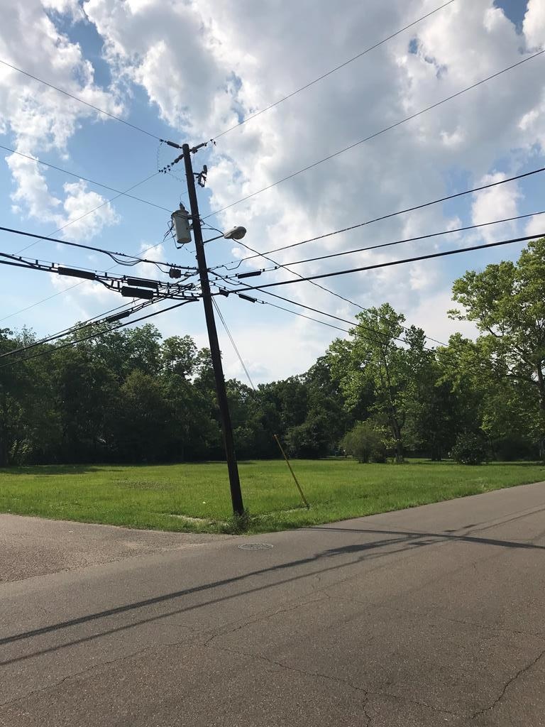
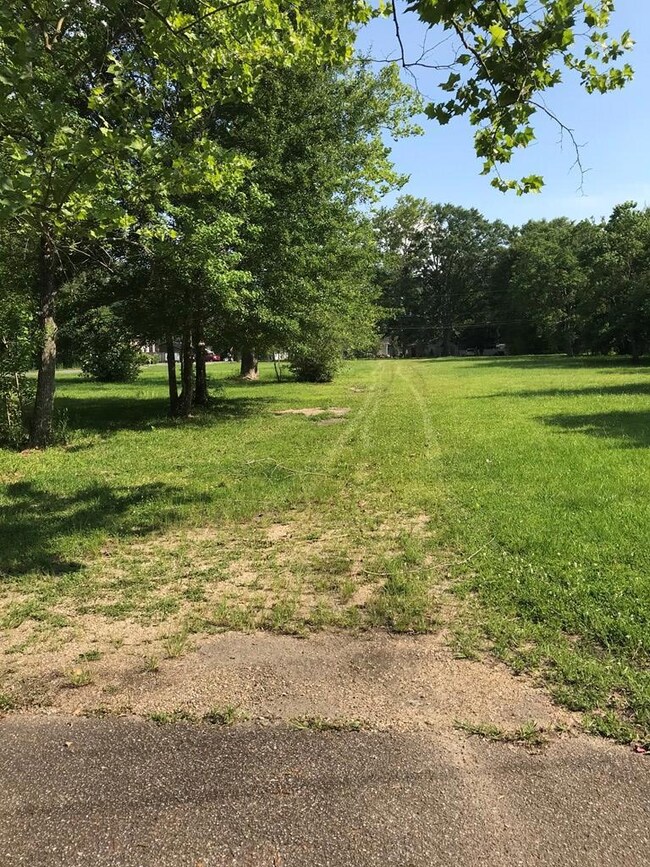
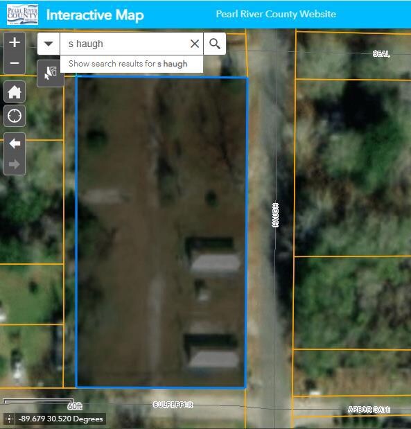
5 city lots ready to build. Zoned R4 for single and multi family units. Water and electric available. Walking distance to restaurants, laundromats, and shopping.

Last Listed By

Leland Thomas

Core Alliance Realty Brokerage Email: 6017491900, lee.corealliance@gmail.com License #S58908 Listed on: 05/19/2023

Property Details

Property Type

  • Land

Est. Annual Taxes

  • $606

Year Built

  • 2000

Lot Details

  • 0.89 Acre Lot
  • Level Lot
  • Cleared Lot

Additional Features

  • City Lot
  • Phone Available

Listing and Financial Details

  • Assessor Parcel Number 6176140030505100

Property Details

Property Type

Land

Est. Annual Taxes

$606

Year Built

2000

Lot Details

0

Listing Details

  • Property Sub Type: Lots/Land
  • Prop. Type: Land
  • Lot Size Acres: 0.8887
  • Road Surface Type: Asphalt
  • Subdivision Name: None
  • Directions: From I-59 and Memorial blvd, go west to Telly Rd, turn right, then turn right onto S Haugh, Property is 3 blocks down on the left.
  • New Construction: No
  • Attribution Contact: 6017491900, lee.corealliance@gmail.com
  • Special Features: None
  • Year Built (Public Record): 2000

Interior Features

  • Possible Use: Residential, Multi-Family

Exterior Features

  • Lot Features: 0-1 acre, City Lot
  • Topography: Level,Cleared
  • Waterfront Features: None
  • Waterfront: No
  • Other Structures: None

Utilities

  • Electricity On Property: Yes
  • Sewer: Public Sewer
  • Utilities: Electricity Available, Phone Available, Water Available
  • Water Source: Public

Schools

  • Junior High Dist: Pic-Westside

Lot Info

  • Current Use: Vacant Lot, Residential Single Family, Residential Multi-Family
  • Lot Size Sq Ft: 38711.772
  • Farm Land Area Units: Square Feet
  • Parcel #: 6176140030505100
  • ResoLotSizeUnits: SquareFeet

Green Features

Multi Family

Tax Info

Ownership History

Date Name Owned For Owner Type

Purchase Details

Closed on
Nov 26, 2024
Sold by
Scat Llc
Bought by
Collier Dennis
Total Days on Market
13
Current Estimated Value
$127,704

Purchase Details

Listed on
May 19, 2023
Closed on
Jul 24, 2023
Sold by
Morris Harold D
Bought by
Scat Llc
Seller's Agent
Leland Thomas
Core Alliance Realty
Buyer's Agent
Leland Thomas
Core Alliance Realty
List Price
$75,000
Sold Price
$75,000
Views
34

Home Financials for this Owner

Home Financials are based on the most recent Mortgage that was taken out on this home.
Avg. Annual Appreciation
34.95%
Original Mortgage
$56,250
Interest Rate
6.11%
Mortgage Type
Construction

Purchase Details

Closed on
May 9, 2019
Sold by
Daughdrill Carole Gail
Bought by
Horris Harold D

Range of Values:

Collateral Analytics

Collateral Analytics Collateral Analytics AVMs (Automated Valuation Model) employ a number of statistical approaches combined with neighborhood-specific comparable selection guarantees the most up-to-date and precise valuations.

Not Available

Collateral Analytics does not have data for the current month. Please view the chart for historical values.

ICE

ICE Mortgage Technology ICE Mortgage Technology’s AVM (Automated Valuation Model) is a state-of-the-art online residential property valuation tool that provides a quick and accurate estimate of the value of almost any home in the U.S.

Not Available

ICE Mortgage Technology does not have data for the current month. Please view the chart for historical values.

First American

First American First American Data & Analytics’ next-generation AVM combines unrivaled data assets with a blended ensemble of valuation models to produce highly accurate, reliable valuations you can trust.

Not Available

First American does not have data for the current month. Please view the chart for historical values.

Quantarium

Quantarium Quantarium’s valuation service, repeatedly proven the industry’s most accurate and comprehensive, is supercharged with a self-learning and auto-tuning AI engine that continually becomes smarter and more accurate as it processes daily inputs from the industry’s leading RE data lake.

Not Available

Quantarium does not have data for the current month. Please view the chart for historical values.

Average Value
Not Available
List Price
Sold Price
Create a Home Valuation Report for This Property
The Home Valuation Report is an in-depth analysis detailing your home's value as well as a comparison with similar homes in the area

Home Values in the Area

Source: Public Records

Average Home Value in this Area


Source: Public Records

Purchase History

Date Buyer Sale Price Title Company
Collier Dennis -- Bayou Title Inc
Scat Llc $70,312 Pilger Title Co
Horris Harold D -- --
Source: Public Records

Mortgage History

Date Status Borrower Loan Amount
Previous Owner Scat Llc $56,250
Source: Public Records

Property History

Date Event Price Change Sq Ft Price
07/24/2023 07/24/23 Sold -- -- --
06/03/2023 06/03/23 Pending -- -- --
05/20/2023 05/20/23 For Sale $75,000 -- --
Source: Pearl River County Board of REALTORS®

Tax History Compared to Growth

Source: Public Records

Tax History

Year Tax Paid Tax Assessment Tax Assessment Total Assessment is a certain percentage of the fair market value that is determined by local assessors to be the total taxable value of land and additions on the property. Land Improvement
2024 $606 $3,750 $0 $0
2023 $606 $2,500 $0 $0
2022 $0 $2,500 $0 $0
2021 -- $2,500 $0 $0
2020 $952 $2,500 $0 $0
2019 $952 $6,166 $0 $0
2018 $955 $6,166 $0 $0
2017 $0 $6,166 $0 $0
2016 $945 $6,166 $0 $0
2015 -- $5,980 $0 $0
2014 -- $5,980 $0 $0
Source: Public Records

Agents Affiliated with this Home

  • Section Image
See All Agents

Map

Source: Pearl River County Board of REALTORS®

MLS Number: 178171

APN: 6-17-6-14-003-050-5100