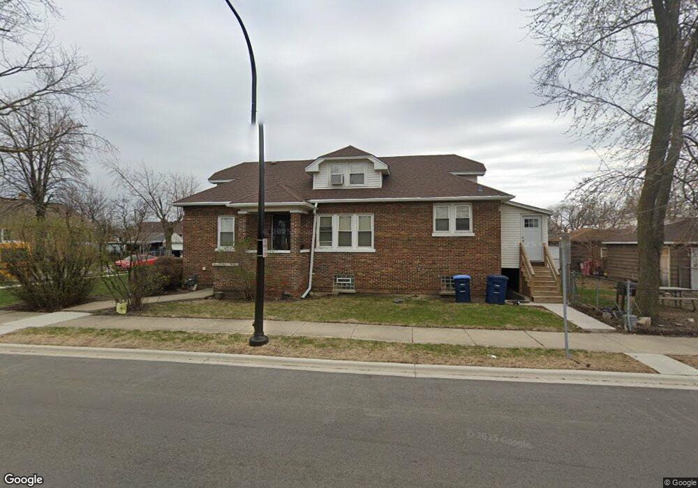
600 S 21st Ave Maywood, IL 60153
West Village NeighborhoodEstimated Value: $267,000 - $351,000
4
Beds
1
Bath
1,762
Sq Ft
$170/Sq Ft
Est. Value
About This Home
This home is located at 600 S 21st Ave, Maywood, IL 60153 and is currently estimated at $300,342, approximately $170 per square foot. 600 S 21st Ave is a home located in Cook County with nearby schools including Thurgood Marshall Elementary School, Roosevelt Middle School, and Proviso West High School.
Ownership History
Date
Name
Owned For
Owner Type
Purchase Details
Closed on
Oct 20, 1995
Sold by
Christensen Thor E and Christensen Charlotte L
Bought by
Thomas Yolanda and Thomas Tarleda J
Current Estimated Value
Home Financials for this Owner
Home Financials are based on the most recent Mortgage that was taken out on this home.
Original Mortgage
$77,812
Outstanding Balance
$550
Interest Rate
7.68%
Mortgage Type
FHA
Estimated Equity
$299,792
Create a Home Valuation Report for This Property
The Home Valuation Report is an in-depth analysis detailing your home's value as well as a comparison with similar homes in the area
Home Values in the Area
Average Home Value in this Area
Purchase History
| Date | Buyer | Sale Price | Title Company |
|---|---|---|---|
| Thomas Yolanda | $78,500 | -- |
Source: Public Records
Mortgage History
| Date | Status | Borrower | Loan Amount |
|---|---|---|---|
| Open | Thomas Yolanda | $77,812 |
Source: Public Records
Tax History Compared to Growth
Tax History
| Year | Tax Paid | Tax Assessment Tax Assessment Total Assessment is a certain percentage of the fair market value that is determined by local assessors to be the total taxable value of land and additions on the property. | Land | Improvement |
|---|---|---|---|---|
| 2024 | $8,481 | $23,000 | $2,542 | $20,458 |
| 2023 | $7,203 | $23,000 | $2,542 | $20,458 |
| 2022 | $7,203 | $16,214 | $2,196 | $14,018 |
| 2021 | $7,282 | $16,213 | $2,195 | $14,018 |
| 2020 | $7,226 | $16,213 | $2,195 | $14,018 |
| 2019 | $6,145 | $13,156 | $1,964 | $11,192 |
| 2018 | $5,975 | $13,156 | $1,964 | $11,192 |
| 2017 | $5,810 | $13,156 | $1,964 | $11,192 |
| 2016 | $6,495 | $12,956 | $1,733 | $11,223 |
| 2015 | $5,981 | $12,956 | $1,733 | $11,223 |
| 2014 | $5,499 | $12,956 | $1,733 | $11,223 |
| 2013 | $5,351 | $15,016 | $1,733 | $13,283 |
Source: Public Records
Map
Nearby Homes
- 634 22nd Ave
- 1910 Washington Blvd
- 628 S 19th Ave
- 646 23rd Ave
- 833 S 21st Ave
- 514 24th Ave
- 430 23rd Ave
- 419 S 18th Ave
- 2420 Randolph St
- 1619 Washington Blvd
- 820 S 17th Ave
- 839 S 18th Ave
- 156 S 18th Ave
- 834 S 16th Ave
- 628 S 15th Ave
- 204 S 16th Ave
- 626 S 14th Ave
- 1231 S 20th Ave
- 328 27th Ave
- 214 22nd Ave
- 602 S 21st Ave
- 606 S 21st Ave
- 444 S 21st Ave
- 608 S 21st Ave
- 2020 Washington Blvd
- 442 S 21st Ave
- 612 S 21st Ave
- 2016 Washington Blvd
- 438 S 21st Ave
- 616 S 21st Ave
- 611 22nd Ave
- 2019 Washington Blvd
- 615 22nd Ave
- 2012 Washington Blvd
- 436 S 21st Ave
- 618 S 21st Ave
- 539 22nd Ave
- 2017 Washington Blvd
- 619 22nd Ave
- 613 S 21st Ave