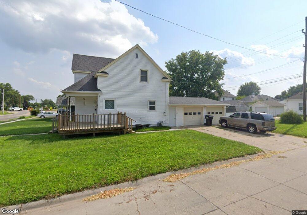
600 S 7th St Norfolk, NE 68701
Estimated Value: $167,000 - $193,000
2
Beds
1
Bath
1,101
Sq Ft
$162/Sq Ft
Est. Value
About This Home
This home is located at 600 S 7th St, Norfolk, NE 68701 and is currently estimated at $178,040, approximately $161 per square foot. 600 S 7th St is a home located in Madison County with nearby schools including Norfolk Senior High School, Keystone Christian Academy, and Christ Lutheran School.
Ownership History
Date
Name
Owned For
Owner Type
Purchase Details
Closed on
Jan 31, 2022
Sold by
Mie Llc
Bought by
Valley Drive Properties Llc
Current Estimated Value
Purchase Details
Closed on
Jul 27, 2021
Sold by
Schrant Michael and Schrant Michael J
Bought by
Schlomer John R and Schlomer Janice A
Purchase Details
Closed on
May 24, 2021
Sold by
Schrant Michael J and Schrant Michael
Bought by
Valley Drive Properties Llc
Create a Home Valuation Report for This Property
The Home Valuation Report is an in-depth analysis detailing your home's value as well as a comparison with similar homes in the area
Home Values in the Area
Average Home Value in this Area
Purchase History
| Date | Buyer | Sale Price | Title Company |
|---|---|---|---|
| Valley Drive Properties Llc | $195,000 | Stewart Title | |
| Schlomer John R | $50,000 | Northeast Nebraska T&E | |
| Valley Drive Properties Llc | $98,000 | None Available |
Source: Public Records
Tax History Compared to Growth
Tax History
| Year | Tax Paid | Tax Assessment Tax Assessment Total Assessment is a certain percentage of the fair market value that is determined by local assessors to be the total taxable value of land and additions on the property. | Land | Improvement |
|---|---|---|---|---|
| 2024 | $1,821 | $145,860 | $7,030 | $138,830 |
| 2023 | $2,422 | $130,985 | $7,030 | $123,955 |
| 2022 | $2,182 | $117,704 | $7,030 | $110,674 |
| 2021 | $2,009 | $108,566 | $7,030 | $101,536 |
| 2020 | $1,802 | $97,687 | $7,030 | $90,657 |
| 2019 | $1,680 | $87,974 | $7,030 | $80,944 |
| 2018 | $1,463 | $77,895 | $5,624 | $72,271 |
| 2017 | $1,319 | $70,152 | $5,624 | $64,528 |
| 2016 | $1,224 | $64,955 | $5,207 | $59,748 |
| 2015 | $1,224 | $64,955 | $5,207 | $59,748 |
| 2014 | $1,206 | $62,110 | $5,207 | $56,903 |
| 2013 | $1,170 | $58,387 | $5,207 | $53,180 |
Source: Public Records
Map
Nearby Homes
- 705 S 10th St
- 602 S 10th St
- 805 S 5th St
- 603 S 4th St
- 918 S 5th St
- 404 S 12th St
- 906 S 4th St
- 410 W Michigan Ave
- 1217 Hayes Ave
- 700 S 2nd St
- 706 Columbia St
- 1208 W Phillip Ave
- 1204 W Madison Ave
- 1200 Prime Stop Way
- 3302 Stonebrooke Ln
- 922 S 2nd St
- 1103 Koenigstein Ave
- 1312 Hayes Ave
- 809 S 1st St
- 1313 W Park Ave