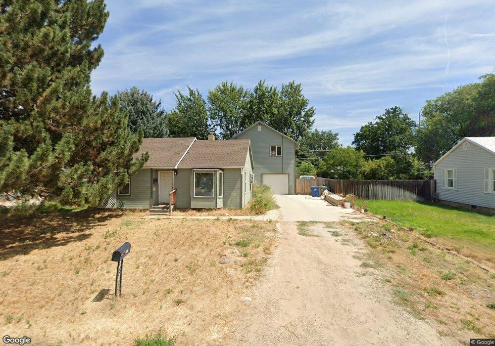
600 Scott St Boise, ID 83705
Central Bench NeighborhoodEstimated Value: $401,000 - $548,000
3
Beds
2
Baths
1,418
Sq Ft
$341/Sq Ft
Est. Value
About This Home
This home is located at 600 Scott St, Boise, ID 83705 and is currently estimated at $483,539, approximately $341 per square foot. 600 Scott St is a home located in Ada County with nearby schools including Hillcrest Elementary School, South Junior High School, and Borah Senior High School.
Ownership History
Date
Name
Owned For
Owner Type
Purchase Details
Closed on
Sep 27, 2022
Sold by
Bu Mercado E Bladmir and Bu Julie M
Bought by
Morrisroe Joseph Bu and Bu Julie M
Current Estimated Value
Home Financials for this Owner
Home Financials are based on the most recent Mortgage that was taken out on this home.
Original Mortgage
$400,000
Outstanding Balance
$382,327
Interest Rate
5.13%
Mortgage Type
New Conventional
Estimated Equity
$101,212
Purchase Details
Closed on
Sep 15, 2022
Sold by
Schaff Richard
Bought by
Morrisroe Joseph Bu and Bu Julie M
Home Financials for this Owner
Home Financials are based on the most recent Mortgage that was taken out on this home.
Original Mortgage
$400,000
Outstanding Balance
$382,327
Interest Rate
5.13%
Mortgage Type
New Conventional
Estimated Equity
$101,212
Create a Home Valuation Report for This Property
The Home Valuation Report is an in-depth analysis detailing your home's value as well as a comparison with similar homes in the area
Home Values in the Area
Average Home Value in this Area
Purchase History
| Date | Buyer | Sale Price | Title Company |
|---|---|---|---|
| Morrisroe Joseph Bu | -- | Pioneer Title | |
| Morrisroe Joseph Bu | -- | Pioneer Title | |
| Morrisroe Joseph Bu | -- | Pioneer Title |
Source: Public Records
Mortgage History
| Date | Status | Borrower | Loan Amount |
|---|---|---|---|
| Open | Morrisroe Joseph Bu | $400,000 | |
| Closed | Morrisroe Joseph Bu | $400,000 |
Source: Public Records
Tax History
| Year | Tax Paid | Tax Assessment Tax Assessment Total Assessment is a certain percentage of the fair market value that is determined by local assessors to be the total taxable value of land and additions on the property. | Land | Improvement |
|---|---|---|---|---|
| 2025 | $2,135 | $384,700 | -- | -- |
| 2024 | $2,148 | $360,300 | -- | -- |
| 2023 | $2,148 | $349,900 | $0 | $0 |
| 2022 | $2,133 | $371,000 | $0 | $0 |
| 2021 | $1,865 | $295,600 | $0 | $0 |
| 2020 | $1,650 | $239,000 | $0 | $0 |
| 2019 | $1,586 | $216,900 | $0 | $0 |
| 2018 | $1,407 | $185,300 | $0 | $0 |
| 2017 | $1,200 | $150,200 | $0 | $0 |
| 2016 | $1,128 | $137,800 | $0 | $0 |
| 2015 | $1,009 | $126,300 | $0 | $0 |
| 2012 | -- | $74,600 | $0 | $0 |
Source: Public Records
Map
Nearby Homes
- 520 S Scott St
- 5612 W Grover St
- 5616 W Grover St
- 5211 Ponder St
- 5404 Anna St
- 824 S Curtis Rd
- 421 S Curtis Rd Unit 122
- 421 S Curtis Rd Unit 118
- 421 S Curtis Rd Unit 34
- 421 S Curtis Rd Unit 2
- 952 S Curtis Rd
- 915 S Curtis Rd Unit 80
- 815 S Curtis Rd Unit 19
- 6226 W Edgewater Dr
- 4816 W Marvin St
- 5231 W Morris Hill Rd
- 5271 W Morris Hill Rd
- 6414 W Randolph Dr
- 6419 W Randolph Dr
- 1161 S Abbey Cir
Your Personal Tour Guide
Ask me questions while you tour the home.