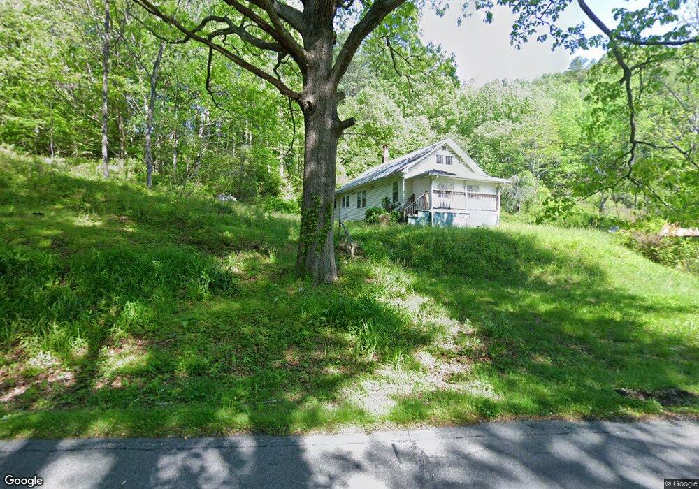
600 Wing Rd Bakersville, NC 28705
Estimated Value: $152,740 - $244,000
3
Beds
1
Bath
956
Sq Ft
$206/Sq Ft
Est. Value
About This Home
This home is located at 600 Wing Rd, Bakersville, NC 28705 and is currently estimated at $197,185, approximately $206 per square foot. 600 Wing Rd is a home located in Mitchell County with nearby schools including Gouge Elementary School, Bowman Middle School, and Mitchell High School.
Ownership History
Date
Name
Owned For
Owner Type
Purchase Details
Closed on
Jun 4, 2025
Sold by
Turner Jennifer Eve and Mechtel Crystal Dawn
Bought by
King Dennis Reece
Current Estimated Value
Purchase Details
Closed on
Aug 15, 2016
Sold by
King Dennis Reece and King Connie Aquino
Bought by
Barton Donna Elizabeth
Purchase Details
Closed on
Jul 10, 2007
Sold by
King Guy Osborn and King Jimie
Bought by
King Jimie and King Patricia L
Create a Home Valuation Report for This Property
The Home Valuation Report is an in-depth analysis detailing your home's value as well as a comparison with similar homes in the area
Home Values in the Area
Average Home Value in this Area
Purchase History
| Date | Buyer | Sale Price | Title Company |
|---|---|---|---|
| King Dennis Reece | -- | None Listed On Document | |
| Barton Donna Elizabeth | -- | Attorney | |
| King Jimie | -- | None Available |
Source: Public Records
Tax History Compared to Growth
Tax History
| Year | Tax Paid | Tax Assessment Tax Assessment Total Assessment is a certain percentage of the fair market value that is determined by local assessors to be the total taxable value of land and additions on the property. | Land | Improvement |
|---|---|---|---|---|
| 2025 | $572 | $89,400 | $43,000 | $46,400 |
| 2024 | $563 | $89,400 | $43,000 | $46,400 |
| 2023 | $563 | $89,400 | $43,000 | $46,400 |
| 2022 | $563 | $89,400 | $43,000 | $46,400 |
| 2021 | $416 | $64,000 | $36,200 | $27,800 |
| 2020 | $416 | $64,000 | $36,200 | $27,800 |
| 2019 | $416 | $64,000 | $36,200 | $27,800 |
| 2018 | $416 | $64,000 | $36,200 | $27,800 |
| 2017 | $422 | $64,900 | $36,200 | $28,700 |
| 2016 | $389 | $64,900 | $36,200 | $28,700 |
| 2015 | $39 | $64,900 | $36,200 | $28,700 |
| 2014 | $389 | $64,900 | $36,200 | $28,700 |
Source: Public Records
Map
Nearby Homes
- 00 Ashland Mountain Rd
- 1371 Wing Rd
- 208 Murdock Rd
- TBD Robert Phillips Rd
- 202 Snow Hill Rd
- 71 Travis Ln
- 5218 S 226 Hwy
- TBD Elkins Rd
- 370 Bear Creek Church Rd
- 00 Elkins Rd
- 75 Appalachian Way
- 496 English Ln
- 607 Fred Sparks Rd
- 3734 Snow Creek Rd
- 1424 Bear Creek Rd
- 249 Starlin Mountain Rd
- 987 White Oak Rd
- 49 Loggy Hollow Rd
- 0 Saylor Lake Rd
- 324 Marble Mine Rd
- 125 Cabin In the Laurel Rd
- 163 Cabin In the Laurel Rd
- 159 Cabin In the Laurel Rd
- 000 Ashland Mountain Dr
- 770 Wing Rd
- 1321 Poplar Creek Rd
- 91 Ashland Mountain Rd Unit 12
- 91 Ashland Mountain Rd
- 13 Poplar Ln
- 170 Ashland Mountain Rd Unit 11
- 218 Ashland Mountain Rd Unit 13
- 00 Poplar Creek Rd
- 717 Snow Creek Rd
- 615 Snow Creek Rd
- 356 Wing Rd
- 403 Turbyfill Rd
- 215 Ashland Mountain Rd Unit 13
- 0 Ashland Mountain Rd Unit NCM546057
- 0 Ashland Mountain Rd Unit 3579018
- 100 Turbyfill Rd