Estimated Value: $229,000 - $312,000
2
Beds
2
Baths
1,962
Sq Ft
$138/Sq Ft
Est. Value
About This Home
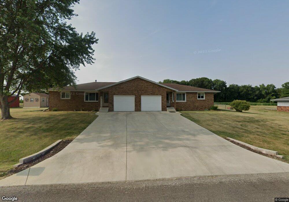
This home is located at 6000 Hartford Dr, Pekin, IL 61554 and is currently estimated at $270,488, approximately $137 per square foot. 6000 Hartford Dr is a home located in Tazewell County with nearby schools including Tremont Elementary School, Tremont Middle School, and Tremont High School.
Ownership History
Date
Name
Owned For
Owner Type
Purchase Details
Closed on
Apr 26, 2018
Sold by
Tanner Leslie A and Tanner Jesse
Bought by
Tanner Leslie A and Tanner Jesse A
Current Estimated Value
Purchase Details
Closed on
Jun 23, 2007
Sold by
Kent Ronda D and Tanner Leslie A
Bought by
Tanner Leslie A and Tanner Jesse
Home Financials for this Owner
Home Financials are based on the most recent Mortgage that was taken out on this home.
Original Mortgage
$140,000
Interest Rate
6.37%
Mortgage Type
Commercial
Create a Home Valuation Report for This Property
The Home Valuation Report is an in-depth analysis detailing your home's value as well as a comparison with similar homes in the area
Purchase History
| Date | Buyer | Sale Price | Title Company |
|---|---|---|---|
| Tanner Leslie A | -- | None Available | |
| Tanner Leslie A | -- | None Available |
Source: Public Records
Mortgage History
| Date | Status | Borrower | Loan Amount |
|---|---|---|---|
| Closed | Tanner Leslie A | $140,000 |
Source: Public Records
Tax History
| Year | Tax Paid | Tax Assessment Tax Assessment Total Assessment is a certain percentage of the fair market value that is determined by local assessors to be the total taxable value of land and additions on the property. | Land | Improvement |
|---|---|---|---|---|
| 2024 | $1,958 | $78,670 | $10,090 | $68,580 |
| 2023 | $1,958 | $72,220 | $9,260 | $62,960 |
| 2022 | $1,958 | $67,240 | $8,620 | $58,620 |
| 2021 | $1,958 | $64,660 | $8,290 | $56,370 |
| 2020 | $1,927 | $63,390 | $8,130 | $55,260 |
| 2019 | $1,928 | $63,390 | $8,130 | $55,260 |
| 2018 | $1,895 | $63,390 | $8,130 | $55,260 |
| 2017 | $4,161 | $62,140 | $7,970 | $54,170 |
| 2016 | $4,100 | $62,140 | $7,970 | $54,170 |
| 2015 | $3,992 | $0 | $0 | $0 |
| 2013 | $3,938 | $62,140 | $7,970 | $54,170 |
Source: Public Records
Map
Nearby Homes
- 1920 - 1922 Mayflower Dr
- 1960-1962 Mayflower Dr
- 201 Royal Point Ct
- 105 Royal Point Ct
- 1960 Mayflower Dr
- 106 Royal Point Ct
- 107 Lost Creek Ct
- 116 Lost Creek Ct
- 4507 Greenlawn Ct
- 21184 Allentown Rd
- 0 Gunion Ave
- 16810 Springfield Rd
- 2841 Allentown Rd
- 104 Thrush Ave
- 100 Thrush Ave
- 303 Powers Ave
- 417 N Toepfer St
- 1833 Highwood Ave
- 1804 Vienna Ct
- 1823 Highwood Ave
- 6215 Hartford Dr
- 6004 Hartford Dr
- 5904 Hartford Dr
- 5907 Hartford Dr
- 6005 Hartford Dr
- 6209 Hartford Dr
- 5900 Hartford Dr
- 6010 Hartford Dr
- 6011 Hartford Dr
- 6212 Hartford Dr
- 6203 Hartford Dr
- 106 Salem Ct
- 5804 Hartford Dr
- 6107 Hartford Dr
- 6208 Hartford Dr
- 101 Salem Ct
- 6101 Hartford Dr
- 5800 Hartford Dr
- 118 Cape Ann Ct
- 108 Salem Ct
Your Personal Tour Guide
Ask me questions while you tour the home.