Estimated Value: $302,981 - $356,000
--
Bed
2
Baths
2,118
Sq Ft
$155/Sq Ft
Est. Value
About This Home
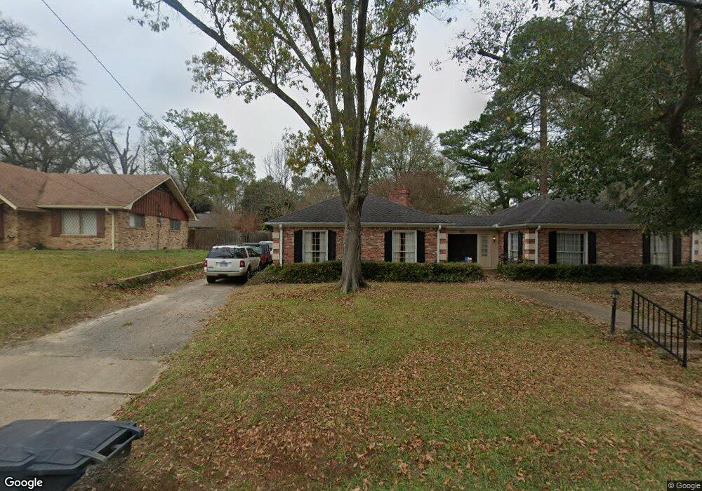
This home is located at 601 Fair Ln, Tyler, TX 75701 and is currently estimated at $327,995, approximately $154 per square foot. 601 Fair Ln is a home located in Smith County with nearby schools including Woods Elementary School, Hogg Middle School, and Tyler Legacy High School.
Ownership History
Date
Name
Owned For
Owner Type
Purchase Details
Closed on
Jul 29, 2008
Sold by
Huggins James C and Huggins Cynthia D
Bought by
Rhodes Barton Jr Neal and Rhodes Barton Bonnie Renee
Current Estimated Value
Home Financials for this Owner
Home Financials are based on the most recent Mortgage that was taken out on this home.
Original Mortgage
$200,848
Outstanding Balance
$131,170
Interest Rate
6.4%
Mortgage Type
Purchase Money Mortgage
Estimated Equity
$196,825
Purchase Details
Closed on
Oct 12, 2007
Sold by
Danbom Jewell Herring and Danbom Stephen Herring
Bought by
Huggins James C and Huggins Cynthia D
Create a Home Valuation Report for This Property
The Home Valuation Report is an in-depth analysis detailing your home's value as well as a comparison with similar homes in the area
Home Values in the Area
Average Home Value in this Area
Purchase History
| Date | Buyer | Sale Price | Title Company |
|---|---|---|---|
| Rhodes Barton Jr Neal | -- | Smith County Title Company | |
| Rhodes Barton Jr Neal | -- | Smith County Title Company | |
| Huggins James C | -- | None Available | |
| Huggins James C | -- | None Available |
Source: Public Records
Mortgage History
| Date | Status | Borrower | Loan Amount |
|---|---|---|---|
| Open | Rhodes Barton Jr Neal | $200,848 | |
| Closed | Rhodes Barton Jr Neal | $200,848 |
Source: Public Records
Tax History Compared to Growth
Tax History
| Year | Tax Paid | Tax Assessment Tax Assessment Total Assessment is a certain percentage of the fair market value that is determined by local assessors to be the total taxable value of land and additions on the property. | Land | Improvement |
|---|---|---|---|---|
| 2025 | $3,917 | $342,186 | $95,620 | $246,566 |
| 2024 | $3,917 | $288,456 | $53,550 | $278,910 |
| 2023 | $3,526 | $344,146 | $53,550 | $290,596 |
| 2022 | $4,671 | $253,646 | $35,700 | $217,946 |
| 2021 | $4,547 | $216,722 | $35,700 | $181,022 |
| 2020 | $4,569 | $213,545 | $35,700 | $177,845 |
| 2019 | $4,360 | $199,384 | $35,700 | $163,684 |
| 2018 | $4,200 | $193,127 | $35,700 | $157,427 |
| 2017 | $4,252 | $199,181 | $35,700 | $163,481 |
| 2016 | $4,215 | $197,417 | $35,700 | $161,717 |
| 2015 | $3,723 | $191,359 | $35,700 | $155,659 |
| 2014 | $3,723 | $186,862 | $35,700 | $151,162 |
Source: Public Records
Map
Nearby Homes
- 0 Us Highway 271
- 2917 Sunnybrook Dr
- 640 Beechwood Dr
- 509 Buckingham Place
- 505 Buckingham Place
- 403 Beechwood Dr
- 789 Fairmont Dr
- 309 Glenhaven Dr
- 1111 Beechwood Dr
- 121 Fair Ln
- 3300 Old Bullard Rd
- 2736 Old Bullard Rd
- 3308 Greenoak Place
- 2900 S Robertson Ave
- 3045 Concord Place
- 2835 S Broadway Ave
- 3324 Teakwood Dr
- 3048 Concord Place
- 2622 Oak Ln
- 2809 S Robertson Ave