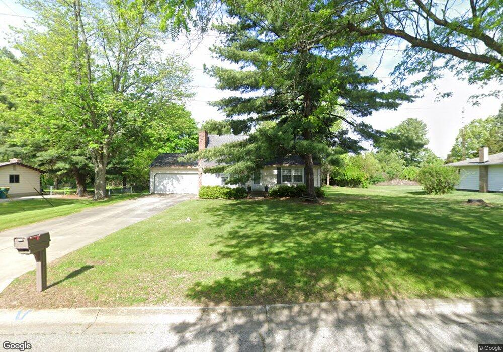
601 Hut West Dr Flushing, MI 48433
Estimated Value: $224,298 - $257,000
3
Beds
2
Baths
1,716
Sq Ft
$143/Sq Ft
Est. Value
About This Home
This home is located at 601 Hut West Dr, Flushing, MI 48433 and is currently estimated at $246,075, approximately $143 per square foot. 601 Hut West Dr is a home located in Genesee County with nearby schools including Central Elementary School, Flushing Middle School, and Flushing High School.
Ownership History
Date
Name
Owned For
Owner Type
Purchase Details
Closed on
Oct 10, 2018
Sold by
Randick Lori A
Bought by
Randick Lori A and Randick Kyle
Current Estimated Value
Purchase Details
Closed on
Mar 8, 2013
Sold by
Jackson Gregory P and Jackson Mary W
Bought by
Randick Lori Ann
Create a Home Valuation Report for This Property
The Home Valuation Report is an in-depth analysis detailing your home's value as well as a comparison with similar homes in the area
Home Values in the Area
Average Home Value in this Area
Purchase History
| Date | Buyer | Sale Price | Title Company |
|---|---|---|---|
| Randick Lori A | -- | None Available | |
| Randick Lori Ann | $101,000 | Sargents Title |
Source: Public Records
Tax History Compared to Growth
Tax History
| Year | Tax Paid | Tax Assessment Tax Assessment Total Assessment is a certain percentage of the fair market value that is determined by local assessors to be the total taxable value of land and additions on the property. | Land | Improvement |
|---|---|---|---|---|
| 2025 | $2,649 | $94,500 | $0 | $0 |
| 2024 | $2,159 | $86,800 | $0 | $0 |
| 2023 | $2,079 | $78,300 | $0 | $0 |
| 2022 | $2,288 | $71,000 | $0 | $0 |
| 2021 | $2,288 | $64,300 | $0 | $0 |
| 2020 | $1,829 | $61,300 | $0 | $0 |
| 2019 | $1,800 | $57,600 | $0 | $0 |
| 2018 | $2,119 | $51,100 | $0 | $0 |
| 2017 | $1,987 | $50,400 | $0 | $0 |
| 2016 | $1,971 | $43,329 | $0 | $0 |
| 2015 | $1,962 | $0 | $0 | $0 |
| 2012 | -- | $49,700 | $49,700 | $0 |
Source: Public Records
Map
Nearby Homes
- 0 Double Tree Estates
- 5082 Prestonwood Ln
- 210 N Hazelton St
- 537 Sharon Dr
- 8520 Apple Blossom Ln
- 428 Leland St
- 212 W Henry St
- 120 Boman St
- 410 E Main St
- 113 N Mckinley Rd
- 5281 Deland Rd
- 544 Warren Ave
- 507 Dale St
- 8474 Wesley Dr
- 5284 Chickasaw Trail
- 515 Chestnut St
- 5315 Chickasaw Trail
- 1011 Clearview Dr
- 308 N Seymour Rd
- 9175 Saddle Horn Dr
- 601 Hut Dr W
- 605 Hut West Dr
- 533 Hut West Dr
- 609 Hut West Dr
- 529 Hut West Dr
- 529 Hut Dr W
- 500 Rodney Ave
- 505 Rodney Ave
- 604 Hut West Dr
- 320 Highlane Dr
- 508 Rodney Ave
- 613 Hut West Dr
- 525 Hut West Dr
- 608 Hut West Dr
- 524 Hut West Dr
- 524 Hut Dr W
- 500 Daniel Ave
- 514 Rodney Ave
- 617 Hut West Dr
- 521 Hut West Dr