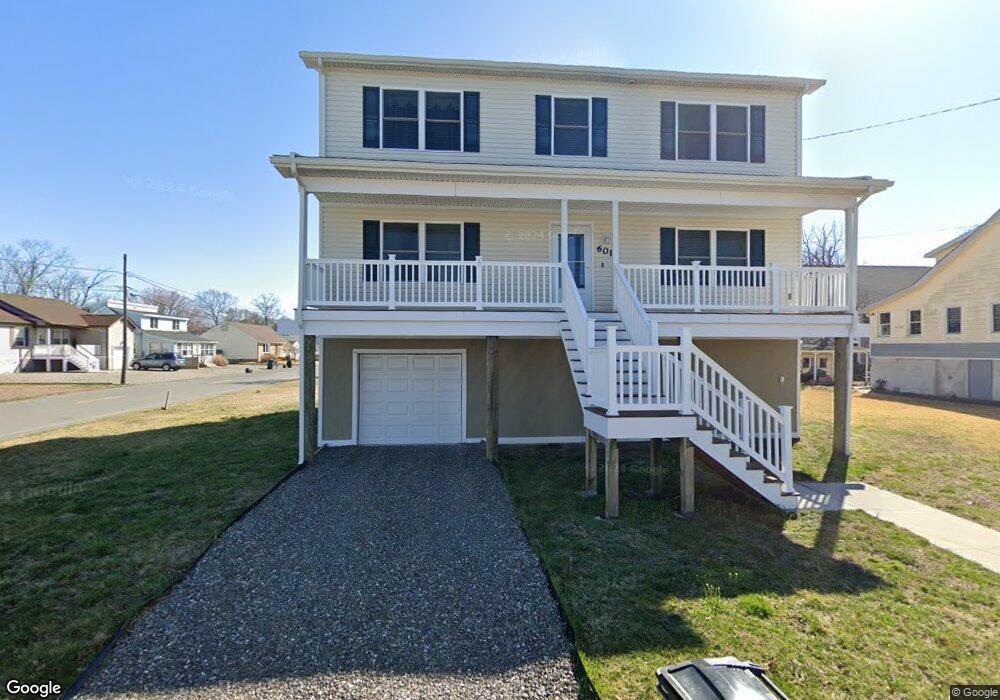
601 Newport Ave Unit 453 Ocean Gate, NJ 08740
Estimated Value: $641,000 - $844,369
4
Beds
3
Baths
2,356
Sq Ft
$299/Sq Ft
Est. Value
About This Home
This home is located at 601 Newport Ave Unit 453, Ocean Gate, NJ 08740 and is currently estimated at $704,342, approximately $298 per square foot. 601 Newport Ave Unit 453 is a home located in Ocean County with nearby schools including Ocean Gate Elementary School, Central Regional Middle School, and Central Regional High School.
Create a Home Valuation Report for This Property
The Home Valuation Report is an in-depth analysis detailing your home's value as well as a comparison with similar homes in the area
Home Values in the Area
Average Home Value in this Area
Tax History Compared to Growth
Tax History
| Year | Tax Paid | Tax Assessment Tax Assessment Total Assessment is a certain percentage of the fair market value that is determined by local assessors to be the total taxable value of land and additions on the property. | Land | Improvement |
|---|---|---|---|---|
| 2025 | $10,043 | $610,900 | $205,500 | $405,400 |
| 2024 | $10,156 | $610,900 | $205,500 | $405,400 |
| 2023 | $9,355 | $336,400 | $84,100 | $252,300 |
| 2022 | $9,355 | $336,400 | $84,100 | $252,300 |
| 2021 | $8,955 | $336,400 | $84,100 | $252,300 |
| 2020 | $9,026 | $336,400 | $84,100 | $252,300 |
| 2019 | $8,807 | $336,400 | $84,100 | $252,300 |
| 2018 | $8,501 | $336,400 | $84,100 | $252,300 |
| 2017 | $2,109 | $84,100 | $84,100 | $0 |
| 2016 | $2,092 | $84,100 | $84,100 | $0 |
| 2015 | $5,246 | $137,500 | $137,500 | $0 |
| 2014 | $5,257 | $256,800 | $137,500 | $119,300 |
Source: Public Records
Map
Nearby Homes
- 409 Newport Ave
- 416 Monmouth Ave
- 318 E Cape May Ave
- 221 E Lakewood Ave
- 142 E Lakewood Ave
- 32 E Long Branch Ave
- 207 Ocean Gate Ave
- 36 W Point Pleasant Ave
- 131 Veeder Ln
- 8 Jibsail Dr
- 21 W Bayview Ave
- 46 Amherst Dr
- 700 Navesink Ave
- 553 Ocean Gate Dr
- 26 Bowsprit Dr
- 54 Beach Ave
- 58 Ronald Ave S
- 0 Jane Ave
- 3 Sheila Ct
- 39 Ivy Ct
- 601 Newport Ave
- 611 Newport Ave
- 600 Newport Ave
- 615 Newport Ave
- 521 Newport Ave
- 614 E Long Branch Ave
- 608 Newport Ave
- 619 Newport Ave
- 611 E Point Pleasant Ave
- 613 E Long Branch Ave
- 519 Newport Ave
- 514 Newport Ave
- 616 Newport Ave
- 624 E Long Branch Ave
- 619 E Point Pleasant Ave
- 619 E Long Branch Ave
- 512 Newport Ave
- 501 Newport Ave
- 628 E Long Branch Ave
- 506 Newport Ave