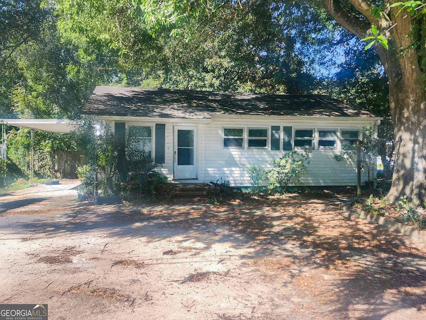
601 Paul St Warner Robins, GA 31088
Estimated payment $420/month
Highlights
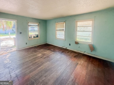
- Ranch Style House
- Wood Flooring
- Patio
- C. B. Watson Primary School Rated A
- No HOA
About This Home
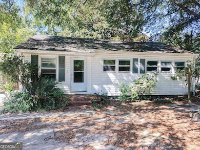
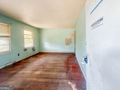
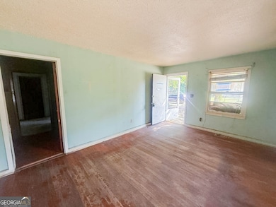
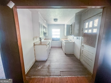
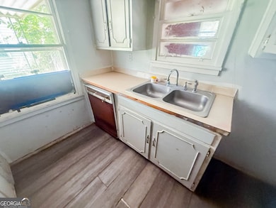
Attention Investors! Don't miss this rare opportunity to transform a ranch-style home with solid potential in the heart of Warner Robins. Offering approximately 965 sq. ft. of living space, this property includes 3 bedrooms, 1 full bath, and a functional floor plan ready for your vision. Built in the 1950s, it showcases classic mid-century character and is primed for a full renovation to bring it back to life. Key features include a rear patio for outdoor enjoyment, a fenced yard that offers privacy and usability, and a convenient 1-car carport. While the home requires repairs and updates throughout, it provides the perfect blank canvas for a fix-and-flip project or long-term rental investment. The location is hard to beat-just minutes from Warner Robins High School, McConnell-Talbert Stadium, and Houston Healthcare/Emory Hospital, plus close to shopping, dining, parks, and everyday conveniences. With its central setting in a growing community, the property combines accessibility with long-term value. Opportunities like this don't stay on the market for long. Whether you're an experienced rehabber or just starting your investment portfolio, this is a chance to create significant value and unlock strong returns. Schedule your showing today and discover the possibilities waiting at 601 Paul Street! Being sold AS IS, WHERE IS, Buyer is responsible for all inspections and any city requirements to close. All information and property details set forth in this listing, including all utilities and all room dimensions which are approximate and deemed reliable but not guaranteed and should be independently verified if any person intends to engage in a transaction based upon it. Seller/current owner does not represent and/or guarantee that all property information and details have been provided in this MLS listing.
Home Details
Home Type
- Single Family
Est. Annual Taxes
- $597
Year Built
- Built in 1953
Home Design
- Ranch Style House
- Composition Roof
- Vinyl Siding
Interior Spaces
- 965 Sq Ft Home
- Wood Flooring
Bedrooms and Bathrooms
- 3 Main Level Bedrooms
- 1 Full Bathroom
Parking
- 1 Parking Space
- Carport
Schools
- Cb Watson/Pearl Stephens Prima Elementary School
- Huntington Middle School
- Warner Robins High School
Utilities
- Window Unit Cooling System
- Heating System Uses Natural Gas
Additional Features
- Patio
- 0.25 Acre Lot
Community Details
- No Home Owners Association
- Highland Hills S/D Subdivision
Map
Home Values in the Area
Average Home Value in this Area
Tax History
| Year | Tax Paid | Tax Assessment Tax Assessment Total Assessment is a certain percentage of the fair market value that is determined by local assessors to be the total taxable value of land and additions on the property. | Land | Improvement |
|---|---|---|---|---|
| 2024 | $670 | $20,480 | $3,800 | $16,680 |
| 2023 | $582 | $17,640 | $3,800 | $13,840 |
| 2022 | $375 | $16,320 | $3,800 | $12,520 |
| 2021 | $275 | $11,880 | $3,800 | $8,080 |
| 2020 | $276 | $11,868 | $3,800 | $8,068 |
| 2019 | $276 | $11,868 | $3,800 | $8,068 |
| 2018 | $276 | $11,868 | $3,800 | $8,068 |
| 2017 | $276 | $11,868 | $3,800 | $8,068 |
| 2016 | $278 | $13,948 | $3,800 | $10,148 |
| 2015 | -- | $13,948 | $3,800 | $10,148 |
| 2014 | -- | $16,148 | $3,800 | $12,348 |
| 2013 | -- | $16,148 | $3,800 | $12,348 |
Property History
| Date | Event | Price | List to Sale | Price per Sq Ft |
|---|---|---|---|---|
| 11/20/2025 11/20/25 | Price Changed | $70,000 | -6.7% | $73 / Sq Ft |
| 10/01/2025 10/01/25 | For Sale | $75,000 | -- | $78 / Sq Ft |
Purchase History
| Date | Type | Sale Price | Title Company |
|---|---|---|---|
| Trustee Deed | $66,102 | None Listed On Document | |
| Warranty Deed | $44,000 | None Available | |
| Deed | -- | -- | |
| Deed | -- | -- | |
| Deed | $19,900 | -- | |
| Deed | -- | -- |
Mortgage History
| Date | Status | Loan Amount | Loan Type |
|---|---|---|---|
| Previous Owner | $44,000 | Purchase Money Mortgage |
Source: Georgia MLS
MLS Number: 10616471
APN: 0W030L014000
Disclaimer: Certain information contained herein is derived from information provided by parties other than Homes.com. All information provided is deemed reliable, but is not guaranteed to be accurate and should be independently verified.
![]() The data relating to real estate for sale on this web site comes in part from the Broker Reciprocity Program of Georgia MLS. Real estate listings held by brokerage firms other than Redfin are marked with the Broker Reciprocity logo and detailed information about them includes the name of the listing brokers. Information deemed reliable but not guaranteed. Copyright 2025 Georgia MLS. All rights reserved.
The data relating to real estate for sale on this web site comes in part from the Broker Reciprocity Program of Georgia MLS. Real estate listings held by brokerage firms other than Redfin are marked with the Broker Reciprocity logo and detailed information about them includes the name of the listing brokers. Information deemed reliable but not guaranteed. Copyright 2025 Georgia MLS. All rights reserved.
- 610 Paul St
- 98 Peachtree Place
- 104 Pleasant Hill Ct
- 1311 Joseph Ave
- 108 Southend Ave
- 812 Crestwood Terrace
- 803 Crestwood Terrace
- 106 Ida Ave
- 108 Ida Ave
- 908 Crestwood Terrace
- 212 Orchard Way
- 214 Kingsbury Cir
- 344 Orchard Way
- 103 Draper St
- 113 Sandra Ave
- 603 S Davis Dr
- 113 Vernon Dr
- 509 S Pleasant Hill Rd
- 204 Deerwood Cir
- 1211 Laura Ave
- 805 Crestwood Terrace
- 106 Draper St
- 216 Meadowdale Dr
- 114 Garland Terrace
- 238 Meadowdale Dr
- 605 S Pleasant Hill Rd
- 1436 Watson Blvd
- 114 Forrester Dr
- 109 Colbert Blvd
- 504 Sunset Dr
- 105 Arnold Blvd
- 102 Lincoln St
- 207 Athens St
- 301 Doyle St Unit A
- 301 Doyle St Unit B
- 2241 Moody Rd
- 104 Williamsburg Ave
- 206 Sunstede Rd
- 200 Sunstede Rd
