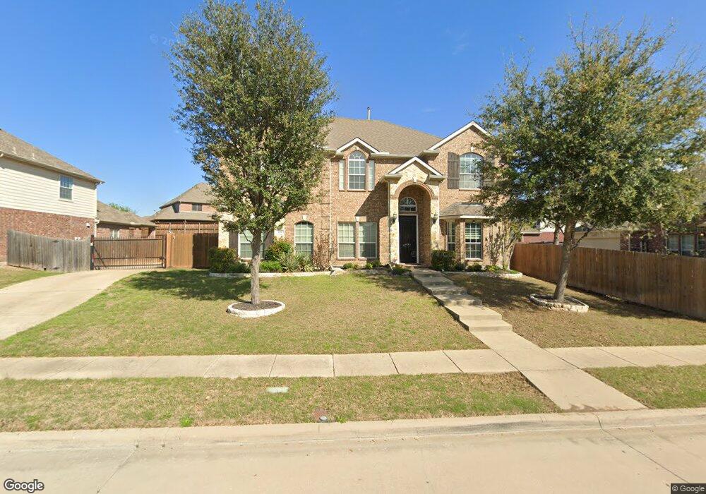
601 Twin Valley Dr Murphy, TX 75094
Estimated Value: $646,688 - $702,000
5
Beds
4
Baths
3,826
Sq Ft
$176/Sq Ft
Est. Value
About This Home
This home is located at 601 Twin Valley Dr, Murphy, TX 75094 and is currently estimated at $674,422, approximately $176 per square foot. 601 Twin Valley Dr is a home located in Collin County with nearby schools including Tibbals Elementary School, Dr. Al Draper Intermediate Middle School, and Raymond B Cooper J High School.
Ownership History
Date
Name
Owned For
Owner Type
Purchase Details
Closed on
Nov 21, 2011
Sold by
First Texas Homes Inc
Bought by
Snopik Kimberly Susan and Snopik Paul Andrew
Current Estimated Value
Home Financials for this Owner
Home Financials are based on the most recent Mortgage that was taken out on this home.
Original Mortgage
$250,791
Outstanding Balance
$25,318
Interest Rate
3.99%
Mortgage Type
New Conventional
Estimated Equity
$649,105
Create a Home Valuation Report for This Property
The Home Valuation Report is an in-depth analysis detailing your home's value as well as a comparison with similar homes in the area
Home Values in the Area
Average Home Value in this Area
Purchase History
| Date | Buyer | Sale Price | Title Company |
|---|---|---|---|
| Snopik Kimberly Susan | -- | Capital Title |
Source: Public Records
Mortgage History
| Date | Status | Borrower | Loan Amount |
|---|---|---|---|
| Open | Snopik Kimberly Susan | $250,791 |
Source: Public Records
Tax History Compared to Growth
Tax History
| Year | Tax Paid | Tax Assessment Tax Assessment Total Assessment is a certain percentage of the fair market value that is determined by local assessors to be the total taxable value of land and additions on the property. | Land | Improvement |
|---|---|---|---|---|
| 2025 | $8,482 | $600,302 | $168,000 | $469,719 |
| 2024 | $8,482 | $545,729 | $147,000 | $483,000 |
| 2023 | $8,482 | $496,117 | $147,000 | $480,491 |
| 2022 | $9,456 | $451,015 | $126,000 | $424,582 |
| 2021 | $9,037 | $410,014 | $94,500 | $315,514 |
| 2020 | $9,604 | $419,459 | $84,000 | $335,459 |
| 2019 | $9,855 | $412,000 | $84,000 | $328,000 |
| 2018 | $9,634 | $399,393 | $84,000 | $315,393 |
| 2017 | $9,151 | $379,404 | $84,000 | $295,404 |
| 2016 | $8,729 | $357,795 | $84,000 | $273,795 |
| 2015 | $7,265 | $345,000 | $63,000 | $282,000 |
Source: Public Records
Map
Nearby Homes
- 620 Fall Wheat Dr
- 517 Royal Oak Dr
- 802 Appalachian Dr
- 728 Morningside Trail
- 413 Royal Oak Dr
- 801 Hunters Glen
- 3119 Connor Ln
- 607 Hilltop Dr
- 563 John Ross Rd
- 404 Crepe Myrtle Ln
- 502 Leeward Dr
- 3014 Eastwood Dr
- 3105 Admiral Dr
- 401 N Maxwell Creek Rd
- 1205 Periwinkle Dr
- 3111 Candlebrook Dr
- 3600 Nandina Dr
- 1013 Chesterfield Dr
- 310 Admiral Dr
- 501 Windward Dr
- 701 Sundown Way
- 705 Sundown Way
- 604 Paint Creek Ct
- 609 Twin Valley Dr
- 640 Fall Wheat Dr
- 709 Sundown Way
- 637 Sundown Way
- 600 Greystone Ct
- 608 Paint Creek Ct
- 608 Greystone Ct
- 613 Twin Valley Dr
- 641 Fall Wheat Dr
- 713 Sundown Way
- 636 Fall Wheat Dr
- 704 Sundown Way
- 700 Sundown Way
- 612 Paint Creek Ct
- 603 Paint Creek Ct
- 708 Sundown Way
- 633 Sundown Way