6010 Highway 2 Epworth, GA 30541
Estimated payment $2,998/month
Highlights
- Additional Residence on Property
- Ranch Style House
- Loft
- Mountain View
- Partially Wooded Lot
- Solid Surface Countertops
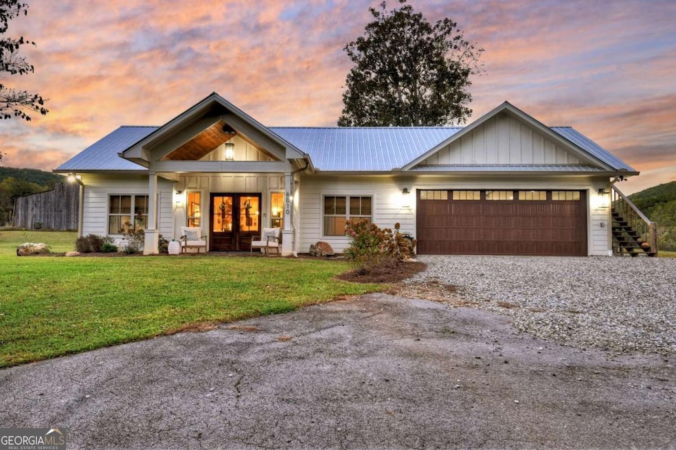
About This Home
Nestled at the base of a stunning mountain backdrop, this storybook 2-bedroom, 2-bath retreat is the perfect blend of cozy charm and thoughtful craftsmanship. Set on a beautifully landscaped property filled with mature trees and lush greenery, every inch of this home feels like a peaceful escape. Step inside to discover a light-filled interior where natural sunlight pours through generous windows, creating a warm and inviting glow throughout. The open living area features custom wood cabinetry and gorgeous matte soapstone countertops - a timeless combination that elevates both style and function. A dedicated pantry and spacious laundry room make daily living effortlessly convenient. The primary suite is a true haven, complete with a walk-in tiled shower, double vanity, and serene views of the surrounding landscape. Every detail feels intentional, from the flow of the layout to the comforting finishes that make this home so special. Outside, unwind on the covered back patio - perfect for a TV, grill, outdoor seating, and a hammock for lazy afternoons. Or gather around the fire pit just as the sun dips behind the mountain, painting the sky in vibrant hues of orange and pink. Additional features include a two-car garage and an unfinished bonus room above the garage, ready to become your future office, guest suite, or creative studio. Whether you're sipping coffee on the patio or watching the sunset by the fire, this home captures the essence of mountain living - peaceful, cozy, and effortlessly beautiful.
Listing Agent
Mountain Sotheby's Int'l Realty Brokerage Phone: 7062225588 License #377874 Listed on: 10/20/2025

Home Details
Home Type
- Single Family
Est. Annual Taxes
- $1,185
Year Built
- Built in 2023
Lot Details
- 1.5 Acre Lot
- Level Lot
- Partially Wooded Lot
- Garden
Parking
- 2 Car Garage
Home Design
- Ranch Style House
- Bungalow
- Slab Foundation
- Metal Roof
Interior Spaces
- 1,200 Sq Ft Home
- Ceiling Fan
- Gas Log Fireplace
- Combination Dining and Living Room
- Loft
- Vinyl Flooring
- Mountain Views
Kitchen
- Breakfast Bar
- Cooktop
- Microwave
- Dishwasher
- Solid Surface Countertops
Bedrooms and Bathrooms
- 2 Main Level Bedrooms
- Walk-In Closet
- 2 Full Bathrooms
- Double Vanity
Laundry
- Laundry in Mud Room
- Laundry Room
Schools
- West Fannin Elementary School
- Fannin County Middle School
- Fannin County High School
Utilities
- Central Heating and Cooling System
- Dual Heating Fuel
- Well
- Tankless Water Heater
- Septic Tank
- High Speed Internet
- Cable TV Available
Additional Features
- Patio
- Additional Residence on Property
Community Details
- No Home Owners Association
Listing and Financial Details
- Tax Lot 230
Map
Home Values in the Area
Average Home Value in this Area
Tax History
| Year | Tax Paid | Tax Assessment Tax Assessment Total Assessment is a certain percentage of the fair market value that is determined by local assessors to be the total taxable value of land and additions on the property. | Land | Improvement |
|---|---|---|---|---|
| 2024 | $1,185 | $129,337 | $5,013 | $124,324 |
| 2023 | $72 | $7,013 | $5,013 | $2,000 |
| 2022 | $65 | $7,013 | $5,013 | $2,000 |
| 2021 | $98 | $7,013 | $5,013 | $2,000 |
| 2020 | $643 | $45,096 | $5,013 | $40,083 |
| 2019 | $655 | $45,096 | $5,013 | $40,083 |
| 2018 | $688 | $44,640 | $4,557 | $40,083 |
| 2017 | $790 | $44,640 | $4,557 | $40,083 |
| 2016 | $495 | $29,135 | $4,557 | $24,578 |
| 2015 | $517 | $29,136 | $4,557 | $24,578 |
| 2014 | $606 | $32,970 | $3,900 | $29,070 |
| 2013 | -- | $21,304 | $3,900 | $17,404 |
Property History
| Date | Event | Price | List to Sale | Price per Sq Ft |
|---|---|---|---|---|
| 10/20/2025 10/20/25 | For Sale | $549,000 | -- | $458 / Sq Ft |
Purchase History
| Date | Type | Sale Price | Title Company |
|---|---|---|---|
| Quit Claim Deed | -- | -- | |
| Limited Warranty Deed | $16,000 | -- | |
| Warranty Deed | $333,333 | -- | |
| Deed | -- | -- |
Mortgage History
| Date | Status | Loan Amount | Loan Type |
|---|---|---|---|
| Open | $279,500 | New Conventional |
Source: Georgia MLS
MLS Number: 10637779
APN: 0021-C-00501
Disclaimer: Certain information contained herein is derived from information provided by parties other than Homes.com. All information provided is deemed reliable, but is not guaranteed to be accurate and should be independently verified.
![]() The data relating to real estate for sale on this web site comes in part from the Broker Reciprocity Program of Georgia MLS. Real estate listings held by brokerage firms other than Redfin are marked with the Broker Reciprocity logo and detailed information about them includes the name of the listing brokers. Information deemed reliable but not guaranteed. Copyright 2025 Georgia MLS. All rights reserved.
The data relating to real estate for sale on this web site comes in part from the Broker Reciprocity Program of Georgia MLS. Real estate listings held by brokerage firms other than Redfin are marked with the Broker Reciprocity logo and detailed information about them includes the name of the listing brokers. Information deemed reliable but not guaranteed. Copyright 2025 Georgia MLS. All rights reserved.
- 181 Sugar Mountain Rd Unit ID1252489P
- 24 Hamby Rd
- 664 Fox Run Dr
- 443 Fox Run Dr Unit ID1018182P
- 226 Church St
- 92 Asbury St
- 524 Old Hwy 5
- 610 Madola Rd Unit 1
- 610 Madola Rd
- 235 Arrowhead Pass
- 600 Indian Trail
- 98 Shalom Ln Unit ID1252436P
- 25 Walhala Trail Unit ID1231291P
- 150 Arrow Way Unit ID1333767P
- 99 Kingtown St
- 88 Black Gum Ln
- 544 E Main St
- 113 Prospect St
- 2680 River Rd
- 423 Laurel Creek Rd