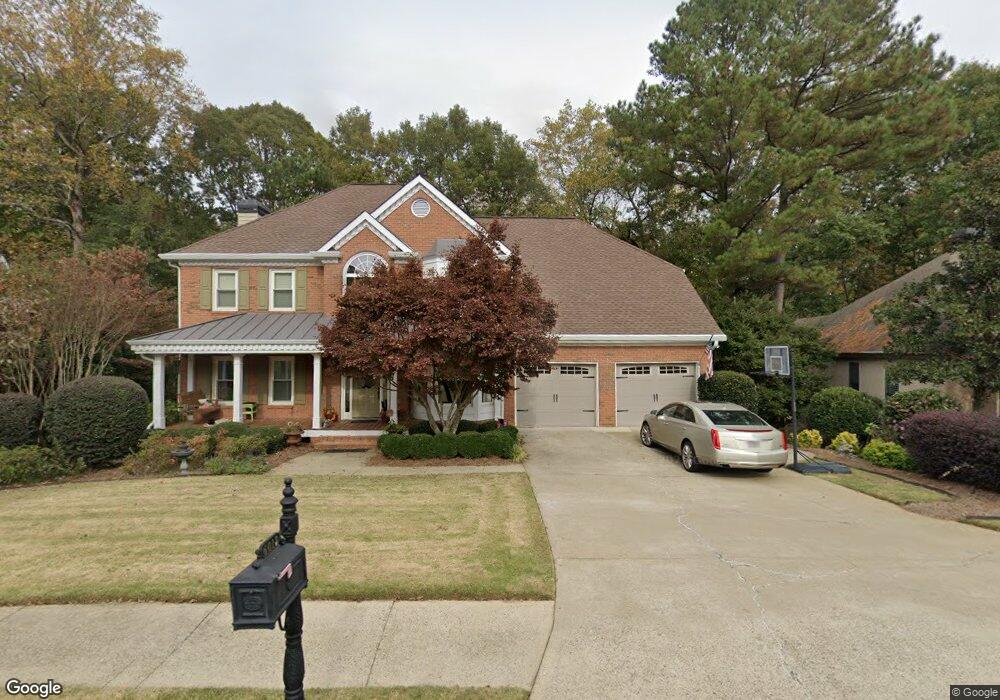
6013 Twinpoint Way Unit IIIB Woodstock, GA 30189
Oak Grove NeighborhoodEstimated Value: $629,892 - $668,000
4
Beds
3
Baths
3,624
Sq Ft
$179/Sq Ft
Est. Value
About This Home
This home is located at 6013 Twinpoint Way Unit IIIB, Woodstock, GA 30189 and is currently estimated at $648,946, approximately $179 per square foot. 6013 Twinpoint Way Unit IIIB is a home located in Cherokee County with nearby schools including Bascomb Elementary School, E. T. Booth Middle School, and Etowah High School.
Ownership History
Date
Name
Owned For
Owner Type
Purchase Details
Closed on
Aug 28, 2001
Sold by
Hawes Robert and Hawes Cheryl
Bought by
Pulliam Robert G and Pulliam Cheri M
Current Estimated Value
Home Financials for this Owner
Home Financials are based on the most recent Mortgage that was taken out on this home.
Original Mortgage
$225,000
Outstanding Balance
$87,098
Interest Rate
6.89%
Mortgage Type
New Conventional
Estimated Equity
$561,848
Purchase Details
Closed on
Oct 30, 1995
Sold by
Bldrsinc Traveler
Bought by
Hawes Robert K Cheryl B
Create a Home Valuation Report for This Property
The Home Valuation Report is an in-depth analysis detailing your home's value as well as a comparison with similar homes in the area
Home Values in the Area
Average Home Value in this Area
Purchase History
| Date | Buyer | Sale Price | Title Company |
|---|---|---|---|
| Pulliam Robert G | $250,000 | -- | |
| Hawes Robert K Cheryl B | $209,900 | -- |
Source: Public Records
Mortgage History
| Date | Status | Borrower | Loan Amount |
|---|---|---|---|
| Open | Pulliam Robert G | $225,000 | |
| Closed | Hawes Robert K Cheryl B | $0 |
Source: Public Records
Tax History Compared to Growth
Tax History
| Year | Tax Paid | Tax Assessment Tax Assessment Total Assessment is a certain percentage of the fair market value that is determined by local assessors to be the total taxable value of land and additions on the property. | Land | Improvement |
|---|---|---|---|---|
| 2024 | $5,374 | $226,048 | $42,000 | $184,048 |
| 2023 | $4,626 | $211,164 | $42,000 | $169,164 |
| 2022 | $4,486 | $181,364 | $25,920 | $155,444 |
| 2021 | $4,196 | $153,000 | $25,920 | $127,080 |
| 2020 | $4,049 | $145,920 | $24,000 | $121,920 |
| 2019 | $3,899 | $139,440 | $24,000 | $115,440 |
| 2018 | $3,870 | $137,640 | $24,000 | $113,640 |
| 2017 | $3,849 | $339,600 | $24,000 | $111,840 |
| 2016 | $3,774 | $329,900 | $24,000 | $107,960 |
| 2015 | $3,289 | $285,400 | $21,200 | $92,960 |
| 2014 | $3,030 | $262,900 | $21,200 | $83,960 |
Source: Public Records
Map
Nearby Homes
- 824 Hillcrest Ln
- 5059 Winding Hills Ln
- 613 Villa Estates Ln
- 559 Fairway Dr
- 542 Fairway Dr
- 569 Fairway Dr
- 510 Deer Cliff Ct
- 4083 Dream Catcher Dr
- 4075 Dream Catcher Dr
- 103 Whirlaway Place Unit 5
- 622 Keeneland Terrace
- 304 Forkwood Trail
- 308 Forkwood Trail
- 2706 Hampton Trail Unit 1
- 3525 Stone Cliff Way
- 900 Santa Anita Dr
- 2814 Andover Way
- 6015 Twinpoint Way
- 6011 Twinpoint Way
- 6012 Twinpoint Way
- 0 Twinpoint Way
- 6014 Twinpoint Way Unit IIIB
- 701 Greenway Trace
- 6009 Twinpoint Way Unit 3B
- 6010 Twinpoint Way Unit 3B
- 703 Greenway Trace
- 6016 Twinpoint Way Unit 111B
- 7012 E Hills Way
- 7016 E Hills Way
- 7010 E Hills Way
- 6007 Twinpoint Way Unit IIIB
- 6008 Twinpoint Way
- 705 Greenway Trace
- 6018 Twinpoint Way
- 0 Greenway Trace
- 6005 Twinpoint Way Unit 3B
- 7008 E Hills Way