
Seller's Agent in 2026
Denise Ardisson
REALTY ONE GROUP GOLD STANDARD
(412) 310-6864
9 in this area
244 Total Sales
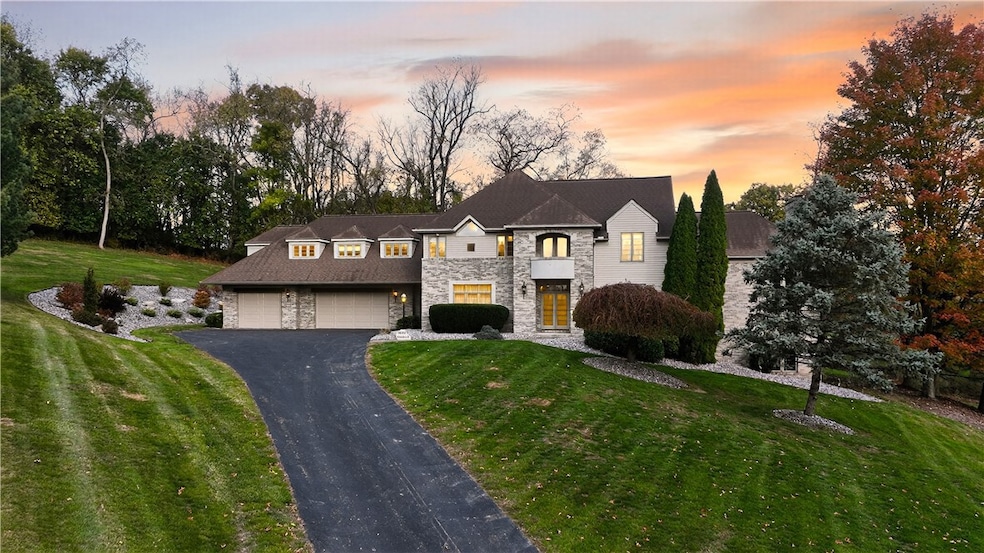


Stunning luxury 5 bedroom home in Penn Township showcasing 3,764 sq foot of meticulously designed living space. Situated on a private 1.1 acre cul de sac homesite that backs to the greens of Westmoreland County club. The grand foyer welcomes you into the home w spacious living room & dining room on each side. An amazing NEW grand kitchen will be a chefs dream. Custom designed space w ample seating at the center island, abundance of storage in the full wall pantry, high end appliances, & abundance of natural light from the large windows. Open to the spacious family room w wood fireplace, wet bar & beamed ceilings Main level also has a 5th bedroom with full bath making the perfect space for an inlaw suite or home office space. Grand master suite with newly renovated luxury bath and three other spacious bedrooms and two full baths are on second level. Walk up attic, abundance of storage closets, large 3 car garage & Large lower level gives you all the space you could need.
Last Agent to Sell the Property
REALTY ONE GROUP GOLD STANDARD License #RS286451 Listed on: 10/31/2025
| Date | Type | Sale Price | Title Company |
|---|---|---|---|
| Interfamily Deed Transfer | -- | -- |
| Date | Event | Price | List to Sale | Price per Sq Ft |
|---|---|---|---|---|
| 02/09/2026 02/09/26 | Sold | $825,000 | -16.2% | $219 / Sq Ft |
| 01/27/2026 01/27/26 | Pending | -- | -- | -- |
| 10/31/2025 10/31/25 | For Sale | $985,000 | -- | $262 / Sq Ft |
| Year | Tax Paid | Tax Assessment Tax Assessment Total Assessment is a certain percentage of the fair market value that is determined by local assessors to be the total taxable value of land and additions on the property. | Land | Improvement |
|---|---|---|---|---|
| 2025 | $10,459 | $76,380 | $10,540 | $65,840 |
| 2024 | $10,382 | $76,380 | $10,540 | $65,840 |
| 2023 | $9,848 | $76,380 | $10,540 | $65,840 |
| 2022 | $9,734 | $76,380 | $10,540 | $65,840 |
| 2021 | $9,658 | $76,380 | $10,540 | $65,840 |
| 2020 | $9,581 | $76,380 | $10,540 | $65,840 |
| 2019 | $9,352 | $76,380 | $10,540 | $65,840 |
| 2018 | $9,085 | $76,380 | $10,540 | $65,840 |
| 2017 | $8,856 | $76,380 | $10,540 | $65,840 |
| 2016 | $8,596 | $76,380 | $10,540 | $65,840 |
| 2015 | $8,596 | $76,380 | $10,540 | $65,840 |
| 2014 | $8,443 | $76,380 | $10,540 | $65,840 |
Seller's Agent in 2026
Denise Ardisson
REALTY ONE GROUP GOLD STANDARD
(412) 310-6864
9 in this area
244 Total Sales
Buyer's Agent in 2026
Adam Slivka
CENTURY 21 FAIRWAYS REAL ESTATE
(724) 787-1659
49 in this area
672 Total Sales
Source: West Penn Multi-List
MLS Number: 1729055
APN: 55-04-16-0-010
Disclaimer: Certain information contained herein is derived from information provided by parties other than Homes.com. All information provided is deemed reliable, but is not guaranteed to be accurate and should be independently verified.
![]() IDX information is provided exclusively for personal, non-commercial use, and may not be used for any purpose other than to identify prospective properties consumers may be interested in purchasing.
IDX information is provided exclusively for personal, non-commercial use, and may not be used for any purpose other than to identify prospective properties consumers may be interested in purchasing.
Information is deemed reliable but not guaranteed.
Ask me questions while you tour the home.