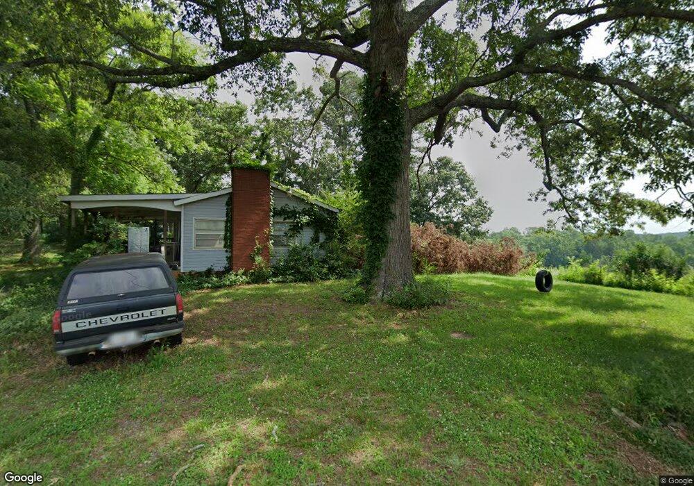
6015 Neisler Rd Cumming, GA 30028
Estimated Value: $416,268 - $462,000
3
Beds
2
Baths
1,728
Sq Ft
$254/Sq Ft
Est. Value
About This Home
This home is located at 6015 Neisler Rd, Cumming, GA 30028 and is currently estimated at $439,317, approximately $254 per square foot. 6015 Neisler Rd is a home located in Forsyth County with nearby schools including Matt Elementary School, Liberty Middle School, and North Forsyth High School.
Ownership History
Date
Name
Owned For
Owner Type
Purchase Details
Closed on
Sep 14, 2001
Sold by
Holbrook James J and Holbrook Stacey R
Bought by
Hollbrook James J and Hollbrook Stacey R
Current Estimated Value
Home Financials for this Owner
Home Financials are based on the most recent Mortgage that was taken out on this home.
Original Mortgage
$130,000
Interest Rate
6.97%
Mortgage Type
New Conventional
Create a Home Valuation Report for This Property
The Home Valuation Report is an in-depth analysis detailing your home's value as well as a comparison with similar homes in the area
Home Values in the Area
Average Home Value in this Area
Purchase History
| Date | Buyer | Sale Price | Title Company |
|---|---|---|---|
| Hollbrook James J | -- | -- |
Source: Public Records
Mortgage History
| Date | Status | Borrower | Loan Amount |
|---|---|---|---|
| Closed | Hollbrook James J | $130,000 |
Source: Public Records
Tax History Compared to Growth
Tax History
| Year | Tax Paid | Tax Assessment Tax Assessment Total Assessment is a certain percentage of the fair market value that is determined by local assessors to be the total taxable value of land and additions on the property. | Land | Improvement |
|---|---|---|---|---|
| 2025 | $2,668 | $156,368 | $69,888 | $86,480 |
| 2024 | $2,668 | $141,584 | $58,464 | $83,120 |
| 2023 | $2,153 | $132,408 | $56,448 | $75,960 |
| 2022 | $2,450 | $94,496 | $35,856 | $58,640 |
| 2021 | $2,165 | $94,496 | $35,856 | $58,640 |
| 2020 | $2,112 | $91,936 | $35,856 | $56,080 |
| 2019 | $1,886 | $80,872 | $25,232 | $55,640 |
| 2018 | $1,723 | $72,352 | $25,232 | $47,120 |
| 2017 | $1,500 | $61,480 | $19,920 | $41,560 |
| 2016 | $1,416 | $57,496 | $15,936 | $41,560 |
| 2015 | $1,419 | $57,496 | $15,936 | $41,560 |
| 2014 | $1,272 | $54,016 | $0 | $0 |
Source: Public Records
Map
Nearby Homes
- 6520 Pond View Dr
- 6470 Pond View Dr
- 6450 Pond View Dr
- 6155 Namon Wallace Rd
- 6745 Dahlgren Ct
- 6420 Durnwald Way
- 6165 Namon Wallace Rd
- 6825 Wallace Creek Ct
- Wieuca Plan at Southbrooke
- Antioch Plan at Southbrooke
- Payton Plan at Southbrooke
- Monteluce Plan at Southbrooke
- Roswell Plan at Southbrooke
- Hendricks Plan at Southbrooke
- Acworth Plan at Southbrooke
- 5395 Coltman Dr
- 6810 Wallace Creek Ct
- 7170 Pond View Dr
- 5860 Bannister Rd
- 6945 Pond View Dr
- 6010 Neisler Rd
- 6005 Neisler Rd
- 6045 Neisler Rd
- 6025 Neisler Rd
- 6620 Pond View Dr
- 6050 Neisler Rd
- 5590 Bower Place
- 5580 Bower Place
- 6070 Hemmert Ln
- 6065 Hemmert Ln
- 5620 Bower Place
- 5570 Bower Place
- 6060 Hemmert Ln
- 5630 Bower Place
- 6055 Hemmert Ln
- 5560 Bower Place
- 0 Neisler Rd Unit 8043954
- 5640 Bower Place
- 6050 Hemmert Ln
- 6035 Neisler Rd