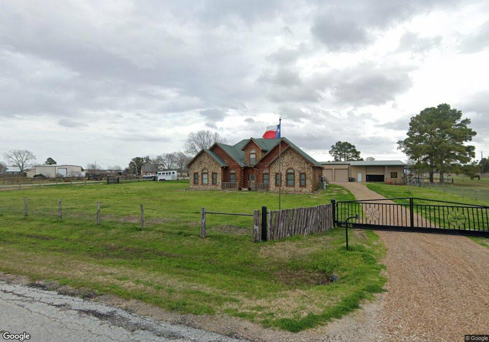
6015 Philip Evan Rd Needville, TX 77461
Estimated Value: $590,000 - $953,000
3
Beds
3
Baths
2,650
Sq Ft
$302/Sq Ft
Est. Value
About This Home
This home is located at 6015 Philip Evan Rd, Needville, TX 77461 and is currently estimated at $799,239, approximately $301 per square foot. 6015 Philip Evan Rd is a home located in Fort Bend County with nearby schools including Needville Elementary School, Needville Junior High School, and Needville Middle School.
Ownership History
Date
Name
Owned For
Owner Type
Purchase Details
Closed on
Jun 24, 2016
Sold by
Tanner Marilyn E
Bought by
Karalis Michael David and Karalis Ashley Gabrielle
Current Estimated Value
Home Financials for this Owner
Home Financials are based on the most recent Mortgage that was taken out on this home.
Original Mortgage
$334,400
Outstanding Balance
$266,145
Interest Rate
3.57%
Estimated Equity
$533,094
Purchase Details
Closed on
May 14, 2013
Sold by
Trigo Joel Merced
Bought by
Tanner Marilyn E
Create a Home Valuation Report for This Property
The Home Valuation Report is an in-depth analysis detailing your home's value as well as a comparison with similar homes in the area
Home Values in the Area
Average Home Value in this Area
Purchase History
| Date | Buyer | Sale Price | Title Company |
|---|---|---|---|
| Karalis Michael David | -- | Startex Title Co | |
| Tanner Marilyn E | -- | Great American Title | |
| Karalis Michael David | -- | -- |
Source: Public Records
Mortgage History
| Date | Status | Borrower | Loan Amount |
|---|---|---|---|
| Open | Karalis Michael David | $334,400 |
Source: Public Records
Tax History Compared to Growth
Tax History
| Year | Tax Paid | Tax Assessment Tax Assessment Total Assessment is a certain percentage of the fair market value that is determined by local assessors to be the total taxable value of land and additions on the property. | Land | Improvement |
|---|---|---|---|---|
| 2025 | $11,073 | $732,050 | $340,847 | $553,402 |
| 2024 | $11,073 | $665,500 | $163,110 | $502,390 |
| 2023 | $10,012 | $605,000 | $101,631 | $503,369 |
| 2022 | $9,843 | $550,000 | $78,290 | $471,710 |
| 2021 | $9,979 | $500,000 | $120,130 | $379,870 |
| 2020 | $9,851 | $464,330 | $120,130 | $344,200 |
| 2019 | $10,413 | $463,440 | $120,130 | $343,310 |
| 2018 | $9,456 | $421,310 | $97,320 | $323,990 |
| 2017 | $8,622 | $383,010 | $56,660 | $326,350 |
| 2016 | $8,486 | $376,990 | $56,660 | $320,330 |
| 2015 | $888 | $38,770 | $38,770 | $0 |
| 2014 | $861 | $38,770 | $38,770 | $0 |
Source: Public Records
Map
Nearby Homes
- 0 Philip Evan Rd
- 6423 Philip Evan Rd
- 4518 Reeh Rd
- 00 Reeh Rd
- 4141 Reeh Rd
- 000 Reeh Rd
- 5225 Fenske Ln
- 5415 Fenske Ln
- 0 Reeh Rd
- 0 Foerster School Rd
- 5410 Sunset Trail
- 0 Whitetail Crossing
- 0 Kunz Rd
- 00 Kunz Rd
- 6515 Williams School Rd
- 0 Williams School Unit 10843392
- 7802 Brinkmeyer Rd
- 4310 Horseshoe Dr
- 6603 Allens Landing
- 6606 Allens Landing
- LOT 5 Philip Evan Rd
- 020 Philip Evan
- 01 Phils
- 01 Philip Evan
- 09 Philip Evan
- 010 Philip Evan
- 0015 Philip Evan
- 4811 Phils Ct
- 6115 Philip Evan Rd
- 0 Philip Evan Rd Unit 64573881
- 0 Philip Evan Rd Unit 9152642
- 0 Philip Evan Rd Unit 5727444
- 0 Philip Evan Rd Unit 46000194
- 0 Philip Evan Rd Unit 80641476
- 4811 Renies Ct
- 5907 Philip Evan Rd
- 00 Philip Evan Rd
- 4802 Renies Ct
- 5815 Philip Evan Rd
- 5110 Reeh Rd