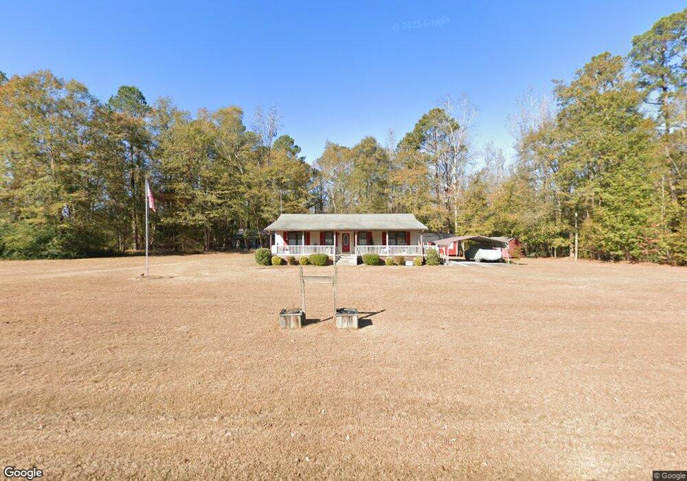
6015 Point Caswell Rd Atkinson, NC 28421
Estimated Value: $162,000 - $333,000
3
Beds
2
Baths
1,274
Sq Ft
$178/Sq Ft
Est. Value
About This Home
This home is located at 6015 Point Caswell Rd, Atkinson, NC 28421 and is currently estimated at $227,229, approximately $178 per square foot. 6015 Point Caswell Rd is a home located in Pender County with nearby schools including Malpass Corner Elementary School, West Pender Middle School, and Pender High School.
Ownership History
Date
Name
Owned For
Owner Type
Purchase Details
Closed on
Aug 28, 2017
Sold by
Horrell Nicholas R and Horrell Christine
Bought by
Walls Walter C and Walls Rosalinda P
Current Estimated Value
Home Financials for this Owner
Home Financials are based on the most recent Mortgage that was taken out on this home.
Original Mortgage
$59,950
Outstanding Balance
$50,143
Interest Rate
3.96%
Mortgage Type
New Conventional
Estimated Equity
$177,086
Purchase Details
Closed on
Oct 23, 2012
Sold by
Horrell Roland T
Bought by
Horrell Nicholas R and Horrell William R
Create a Home Valuation Report for This Property
The Home Valuation Report is an in-depth analysis detailing your home's value as well as a comparison with similar homes in the area
Home Values in the Area
Average Home Value in this Area
Purchase History
| Date | Buyer | Sale Price | Title Company |
|---|---|---|---|
| Walls Walter C | $62,000 | None Available | |
| Horrell Nicholas R | -- | None Available |
Source: Public Records
Mortgage History
| Date | Status | Borrower | Loan Amount |
|---|---|---|---|
| Open | Walls Walter C | $59,950 |
Source: Public Records
Tax History Compared to Growth
Tax History
| Year | Tax Paid | Tax Assessment Tax Assessment Total Assessment is a certain percentage of the fair market value that is determined by local assessors to be the total taxable value of land and additions on the property. | Land | Improvement |
|---|---|---|---|---|
| 2024 | $1,340 | $125,221 | $28,870 | $96,351 |
| 2023 | $1,327 | $125,221 | $28,870 | $96,351 |
| 2022 | $1,231 | $125,221 | $28,870 | $96,351 |
| 2021 | $1,231 | $125,221 | $28,870 | $96,351 |
| 2020 | $1,231 | $125,221 | $28,870 | $96,351 |
| 2019 | $1,231 | $125,221 | $28,870 | $96,351 |
| 2018 | $10 | $95,175 | $27,388 | $67,787 |
| 2017 | $10 | $95,175 | $27,388 | $67,787 |
| 2016 | $1,017 | $95,175 | $27,388 | $67,787 |
| 2015 | $982 | $95,175 | $27,388 | $67,787 |
| 2014 | $796 | $95,175 | $27,388 | $67,787 |
| 2013 | -- | $95,175 | $27,388 | $67,787 |
| 2012 | -- | $95,175 | $27,388 | $67,787 |
Source: Public Records
Map
Nearby Homes
- 1744 Rooks Rd
- 200 E Main St
- 118 E Church St
- 3848 Rooks Rd
- 3213 Rooks Rd
- 623 Big 4 Rd
- 2092 John Henry Store Rd
- 0 Slocum Trail Unit 100530473
- 5350 Slocum Trail
- 5370 Slocum Trail
- 0000 Beattys Bridge Rd
- 3763 Bell Williams Rd
- 6185 Slocum Trail
- 2216 Bell Williams Rd
- 0 Newtown Loop Rd
- 6079 Bell Williams Rd
- 325 Messer Loop Rd
- 8033 Malpass Corner Rd
- 1152 Point Caswell Rd
- 1327 Point Caswell Rd
- 6060 Point Caswell Rd
- 5990 Point Caswell Rd
- 6141 Point Caswell Rd
- 5880 Point Caswell Rd
- 6215 Point Caswell Rd
- 6300 Point Caswell Rd
- 6395 Point Caswell Rd
- 5615 Point Caswell Rd
- 6434 Point Caswell Rd
- 925 Bostic Rd
- 1395 Rooks Rd
- 1121 Rooks Rd
- 1075 Rooks Rd
- 801 Bostic Rd
- 5400 Point Caswell Rd
- 789 Bostic Rd
- 785 Bostic Rd
- 5350 Point Caswell Rd
- 1808 Rooks Rd
- 6450 Point Caswell Rd