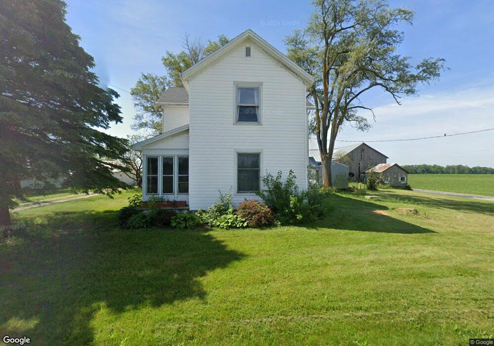
6015 State Route 722 Arcanum, OH 45304
Estimated Value: $290,000 - $421,000
4
Beds
1
Bath
2,160
Sq Ft
$161/Sq Ft
Est. Value
About This Home
This home is located at 6015 State Route 722, Arcanum, OH 45304 and is currently estimated at $346,798, approximately $160 per square foot. 6015 State Route 722 is a home with nearby schools including Arcanum Elementary School, Butler Middle School, and Arcanum High School.
Ownership History
Date
Name
Owned For
Owner Type
Purchase Details
Closed on
Jan 31, 2007
Sold by
Price Charles R
Bought by
Stephens Johnathan N and Stephens Mary K
Current Estimated Value
Home Financials for this Owner
Home Financials are based on the most recent Mortgage that was taken out on this home.
Original Mortgage
$162,000
Outstanding Balance
$94,880
Interest Rate
6.22%
Mortgage Type
Purchase Money Mortgage
Estimated Equity
$251,918
Purchase Details
Closed on
Sep 25, 2006
Sold by
Weiss Charles R and Weiss Krista L
Bought by
Karns Diana I
Home Financials for this Owner
Home Financials are based on the most recent Mortgage that was taken out on this home.
Original Mortgage
$155,000
Interest Rate
10.25%
Mortgage Type
Purchase Money Mortgage
Create a Home Valuation Report for This Property
The Home Valuation Report is an in-depth analysis detailing your home's value as well as a comparison with similar homes in the area
Purchase History
| Date | Buyer | Sale Price | Title Company |
|---|---|---|---|
| Stephens Johnathan N | $42,000 | Attorney | |
| Karns Diana I | $155,000 | Prodigy Title Agency Llc |
Source: Public Records
Mortgage History
| Date | Status | Borrower | Loan Amount |
|---|---|---|---|
| Open | Stephens Johnathan N | $162,000 | |
| Previous Owner | Karns Diana I | $155,000 |
Source: Public Records
Tax History
| Year | Tax Paid | Tax Assessment Tax Assessment Total Assessment is a certain percentage of the fair market value that is determined by local assessors to be the total taxable value of land and additions on the property. | Land | Improvement |
|---|---|---|---|---|
| 2025 | $2,161 | $81,270 | $34,380 | $46,890 |
| 2024 | $2,161 | $81,270 | $34,380 | $46,890 |
| 2023 | $2,164 | $81,270 | $34,380 | $46,890 |
| 2022 | $1,831 | $68,380 | $30,810 | $37,570 |
| 2021 | $1,846 | $68,380 | $30,810 | $37,570 |
| 2020 | $1,789 | $68,380 | $30,810 | $37,570 |
| 2019 | $1,668 | $62,170 | $30,870 | $31,300 |
| 2018 | $1,655 | $62,170 | $30,870 | $31,300 |
| 2017 | $1,510 | $59,680 | $28,380 | $31,300 |
| 2016 | $1,512 | $53,860 | $26,760 | $27,100 |
| 2015 | $1,512 | $53,860 | $26,760 | $27,100 |
| 2014 | $1,531 | $53,860 | $26,760 | $27,100 |
| 2013 | $1,389 | $50,340 | $23,240 | $27,100 |
Source: Public Records
Map
Nearby Homes
- 0 Friday Rd
- 0 Ohio 722 Unit 10052561
- 0 Ohio 722 Unit 949232
- 0 Ohio 722 Unit 1042963
- 6614 Otterbein-Ithaca Rd
- 6614 Otterbein Ithaca Rd
- 1485 State Route 503
- 246 N Main St
- 4790 Grubbs Rex Rd
- 7404 Grubbs Rex Rd
- 217 Orchard St
- 404 W 1st St
- 6492 Hollansburg Arcanum Rd
- 405 East St
- 2 N Main St
- 4 N Main St
- 201 W George St
- 7888 Darke Preble County Line Rd
- 7888 Darke Preble Co Line Rd
- 210 E South St
- 787 Loop Rd
- 6071 State Route 722
- 5953 State Route 722
- 6102 State Route 722
- 6099 State Route 722
- 6117 State Route 722
- 6123 State Route 722
- 6161 State Route 722
- 5823 State Route 722
- 6198 State Route 722
- 576 Loop Rd
- 6227 State Route 722
- 5809 State Route 722
- 6302 Clark Rd
- 6226 State Route 722
- 6254 State Route 722
- 6251 State Route 722
- 6306 Clark Rd
- 6058 Clark Rd
- 6011 Clark Rd
Your Personal Tour Guide
Ask me questions while you tour the home.