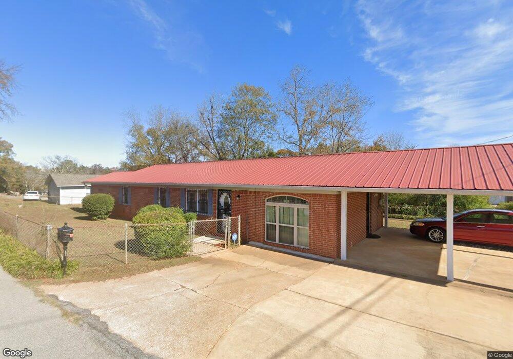
602 Avenue O West Point, GA 31833
Estimated Value: $132,657 - $159,000
3
Beds
2
Baths
1,538
Sq Ft
$94/Sq Ft
Est. Value
About This Home
This home is located at 602 Avenue O, West Point, GA 31833 and is currently estimated at $144,664, approximately $94 per square foot. 602 Avenue O is a home located in Troup County with nearby schools including West Point Elementary School, Long Cane Elementary School, and Whitesville Road Elementary School.
Ownership History
Date
Name
Owned For
Owner Type
Purchase Details
Closed on
Oct 5, 1988
Sold by
Forrester R Davidson
Bought by
Stafford Katherine
Current Estimated Value
Purchase Details
Closed on
Oct 1, 1988
Sold by
Sons & Daughters Of Jacob
Bought by
Forrester R Davidson
Purchase Details
Closed on
Jan 1, 1952
Sold by
Julia Davidson
Bought by
Sons & Daughters Of Jacob
Create a Home Valuation Report for This Property
The Home Valuation Report is an in-depth analysis detailing your home's value as well as a comparison with similar homes in the area
Home Values in the Area
Average Home Value in this Area
Purchase History
| Date | Buyer | Sale Price | Title Company |
|---|---|---|---|
| Stafford Katherine | $29,000 | -- | |
| Forrester R Davidson | -- | -- | |
| Sons & Daughters Of Jacob | -- | -- |
Source: Public Records
Tax History Compared to Growth
Tax History
| Year | Tax Paid | Tax Assessment Tax Assessment Total Assessment is a certain percentage of the fair market value that is determined by local assessors to be the total taxable value of land and additions on the property. | Land | Improvement |
|---|---|---|---|---|
| 2024 | $696 | $40,408 | $2,160 | $38,248 |
| 2023 | $183 | $40,208 | $2,160 | $38,048 |
| 2022 | $349 | $37,048 | $2,160 | $34,888 |
| 2021 | $1,022 | $35,892 | $2,160 | $33,732 |
| 2020 | $522 | $19,300 | $800 | $18,500 |
| 2019 | $494 | $18,352 | $808 | $17,544 |
| 2018 | $469 | $17,548 | $808 | $16,740 |
| 2017 | $469 | $17,548 | $808 | $16,740 |
| 2016 | $452 | $16,972 | $808 | $16,164 |
| 2015 | $453 | $16,972 | $808 | $16,164 |
| 2014 | $428 | $16,122 | $808 | $15,314 |
| 2013 | -- | $17,305 | $808 | $16,497 |
Source: Public Records
Map
Nearby Homes
- 509 Cleveland St
- 0 Arrowhead Dr Unit 10451860
- 804 E 6th St
- 713 Avenue H
- 1008 E 12th St
- 0 Sunset Dr Unit 10451831
- 311 E 4th St
- 112 Hillcrest Rd
- 128 Highland Dr
- 1505 Wisteria Dr
- 4517 Georgia 18
- 4509 Georgia 18
- 4523 Georgia 18
- 4527 Georgia 18
- 712 4th Ave
- 1007 4th Ave
- 508 Pine St
- 107 Garden Walk
- 1410 Roper Ave
- 1314 4th Ave
- 1300 Hatchett St
- 1402 E 7th St
- 1317 Glen St
- 503 Martin Luther King Dr
- 503 Martin Luther King jr Dr
- 1304 E 7th St
- 600 Avenue N
- 604 Avenue N
- 626 Martin Luther King Dr
- 624 Martin Luther King Dr
- 506 Avenue N
- 700 Martin Luther King Dr
- 1309 Glen St
- 603 Avenue N
- 1315 Glen St
- 1315 & 1317 Glen St
- 622 Martin Luther King Dr
- 704 Martin Luther King Dr
- 1212 E 7th St
- 702 Martin Luther King Dr