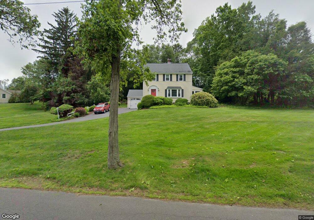
602 Chestnut Ridge Rd Orange, CT 06477
Estimated Value: $518,988 - $586,000
3
Beds
2
Baths
1,448
Sq Ft
$381/Sq Ft
Est. Value
About This Home
This home is located at 602 Chestnut Ridge Rd, Orange, CT 06477 and is currently estimated at $551,747, approximately $381 per square foot. 602 Chestnut Ridge Rd is a home located in New Haven County with nearby schools including Mary L. Tracy School, Race Brook School, and Amity Middle School: Orange.
Ownership History
Date
Name
Owned For
Owner Type
Purchase Details
Closed on
Sep 2, 1992
Sold by
Merold Doris A
Bought by
Kochiss William M and Silverman Lisa J
Current Estimated Value
Home Financials for this Owner
Home Financials are based on the most recent Mortgage that was taken out on this home.
Original Mortgage
$147,200
Interest Rate
8.09%
Mortgage Type
Unknown
Create a Home Valuation Report for This Property
The Home Valuation Report is an in-depth analysis detailing your home's value as well as a comparison with similar homes in the area
Home Values in the Area
Average Home Value in this Area
Purchase History
| Date | Buyer | Sale Price | Title Company |
|---|---|---|---|
| Kochiss William M | $184,000 | -- | |
| Kochiss William M | $184,000 | -- |
Source: Public Records
Mortgage History
| Date | Status | Borrower | Loan Amount |
|---|---|---|---|
| Open | Kochiss William M | $225,300 | |
| Closed | Kochiss William M | $236,500 | |
| Closed | Kochiss William M | $157,000 | |
| Closed | Kochiss William M | $147,200 |
Source: Public Records
Tax History Compared to Growth
Tax History
| Year | Tax Paid | Tax Assessment Tax Assessment Total Assessment is a certain percentage of the fair market value that is determined by local assessors to be the total taxable value of land and additions on the property. | Land | Improvement |
|---|---|---|---|---|
| 2025 | $8,710 | $299,300 | $155,500 | $143,800 |
| 2024 | $9,278 | $299,300 | $155,500 | $143,800 |
| 2023 | $6,950 | $215,100 | $113,500 | $101,600 |
| 2022 | $7,036 | $215,100 | $113,500 | $101,600 |
| 2021 | $7,152 | $215,100 | $113,500 | $101,600 |
| 2020 | $7,042 | $215,100 | $113,500 | $101,600 |
| 2019 | $7,010 | $215,100 | $113,500 | $101,600 |
| 2018 | $6,883 | $215,100 | $113,500 | $101,600 |
| 2017 | $6,653 | $199,900 | $108,400 | $91,500 |
| 2016 | $6,437 | $199,900 | $108,400 | $91,500 |
| 2015 | $6,277 | $199,900 | $108,400 | $91,500 |
| 2014 | $6,097 | $199,900 | $108,400 | $91,500 |
Source: Public Records
Map
Nearby Homes
- 588 Summit Dr
- 189 Derby Ave
- 846 Beechwood Rd
- 14 Ironwood Way
- 484 New England Ln
- 100 Yates St
- 78 Nonquit St
- 265 Tuthill St
- 57 Dalton St
- 39 Medford St
- 8 Farm River Rd
- 0 Burwell & Woodfield Rd Unit 24051262
- 0 Burwell Rd
- 107 Tuthill St
- 1025 Field Dr
- 50 Morris Ave
- 11 Priscilla Rd
- 700 Royal Ln
- 47 Sunset Dr
- 62 Tuthill St
- 594 Chestnut Ridge Rd
- 612 Chestnut Ridge Rd
- 601 Chestnut Ridge Rd
- 609 Chestnut Ridge Rd
- 595 Chestnut Ridge Rd
- 586 Chestnut Ridge Rd
- 616 Chestnut Ridge Rd
- 241 Bittersweet Rd
- 587 Chestnut Ridge Rd
- 605 Dogwood Rd
- 245 Bittersweet Rd
- 585 Dogwood Rd
- 605 Dogwood Rd
- 581 Chestnut Ridge Rd
- 622 Chestnut Ridge Rd
- 607 Dogwood Rd
- 242 Bittersweet Rd
- 251 Bittersweet Rd
- 259 Hunting Hill Rd
- 246 Bittersweet Rd