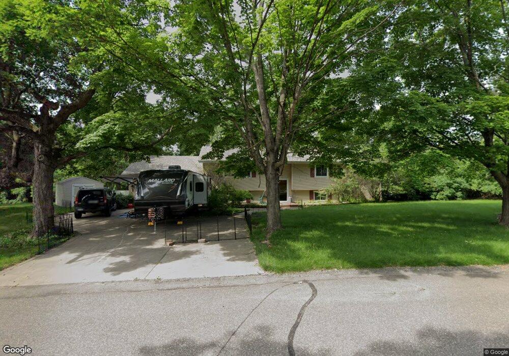
602 Circle Dr Buffalo, MN 55313
Estimated Value: $341,906 - $361,000
4
Beds
2
Baths
2,914
Sq Ft
$121/Sq Ft
Est. Value
About This Home
This home is located at 602 Circle Dr, Buffalo, MN 55313 and is currently estimated at $352,227, approximately $120 per square foot. 602 Circle Dr is a home located in Wright County with nearby schools including Northwinds Elementary School, Buffalo Community Middle School, and Buffalo Senior High School.
Ownership History
Date
Name
Owned For
Owner Type
Purchase Details
Closed on
Oct 23, 2015
Sold by
Lund Kenneth Kenneth
Bought by
Purdy Clarice Clarice
Current Estimated Value
Home Financials for this Owner
Home Financials are based on the most recent Mortgage that was taken out on this home.
Original Mortgage
$194,000
Outstanding Balance
$152,169
Interest Rate
3.79%
Estimated Equity
$200,058
Purchase Details
Closed on
Jul 28, 2004
Sold by
Cameron Laurie G
Bought by
Lund Kenneth L and Lund Diane
Create a Home Valuation Report for This Property
The Home Valuation Report is an in-depth analysis detailing your home's value as well as a comparison with similar homes in the area
Home Values in the Area
Average Home Value in this Area
Purchase History
| Date | Buyer | Sale Price | Title Company |
|---|---|---|---|
| Purdy Clarice Clarice | $195,000 | -- | |
| Lund Kenneth L | $200,000 | -- |
Source: Public Records
Mortgage History
| Date | Status | Borrower | Loan Amount |
|---|---|---|---|
| Open | Purdy Clarice Clarice | $194,000 |
Source: Public Records
Tax History
| Year | Tax Paid | Tax Assessment Tax Assessment Total Assessment is a certain percentage of the fair market value that is determined by local assessors to be the total taxable value of land and additions on the property. | Land | Improvement |
|---|---|---|---|---|
| 2025 | $3,542 | $305,700 | $75,000 | $230,700 |
| 2024 | $3,512 | $294,700 | $70,000 | $224,700 |
| 2023 | $3,428 | $298,900 | $70,000 | $228,900 |
| 2022 | $3,278 | $272,500 | $64,000 | $208,500 |
| 2021 | $3,346 | $236,200 | $50,000 | $186,200 |
| 2020 | $3,062 | $236,400 | $45,000 | $191,400 |
| 2019 | $2,562 | $212,200 | $0 | $0 |
| 2018 | $2,452 | $172,600 | $0 | $0 |
| 2017 | $2,228 | $164,800 | $0 | $0 |
| 2016 | $1,698 | $0 | $0 | $0 |
| 2015 | $1,606 | $0 | $0 | $0 |
| 2014 | -- | $0 | $0 | $0 |
Source: Public Records
Map
Nearby Homes
- 811 Myrtle St
- 623 Amber Ln
- 1406 Landsdown Rd
- TBD Lake Blvd
- 1487 Baker Ave NW
- 407 12th St NW
- 1400 Grandview Ave
- 101 Big Woods Ct
- 207 6th St NW
- 2368 Barton Ave NW
- 209 9th St NW
- 201 1st Ave NW
- 308 Central Ave
- xxx 2nd Ave NE
- 107 2nd Ave NE
- 305 Arcadian Place Unit 1
- 202 Lake Blvd S
- 312 Arcadian Place Unit 8
- 607 8th St NE Unit A
- 607 1st St NE
- 104 Lookout Point
- 102 Lookout Point
- 604 Circle Dr
- 106 Lookout Point
- 927 Circle Dr
- 701 Circle Dr
- 606 Circle Dr
- 714 Overlook Dr
- 108 Lookout Point
- 712 Overlook Dr
- 1013 Ridgehaven Cir
- 1011 Ridgehaven Cir
- 608 Circle Dr
- 110 Lookout Point
- 923 Circle Dr
- 703 Circle Dr
- 1017 Ridgehaven Cir
- 710 Overlook Dr
- 713 Overlook Dr
- 921 Circle Dr
Your Personal Tour Guide
Ask me questions while you tour the home.