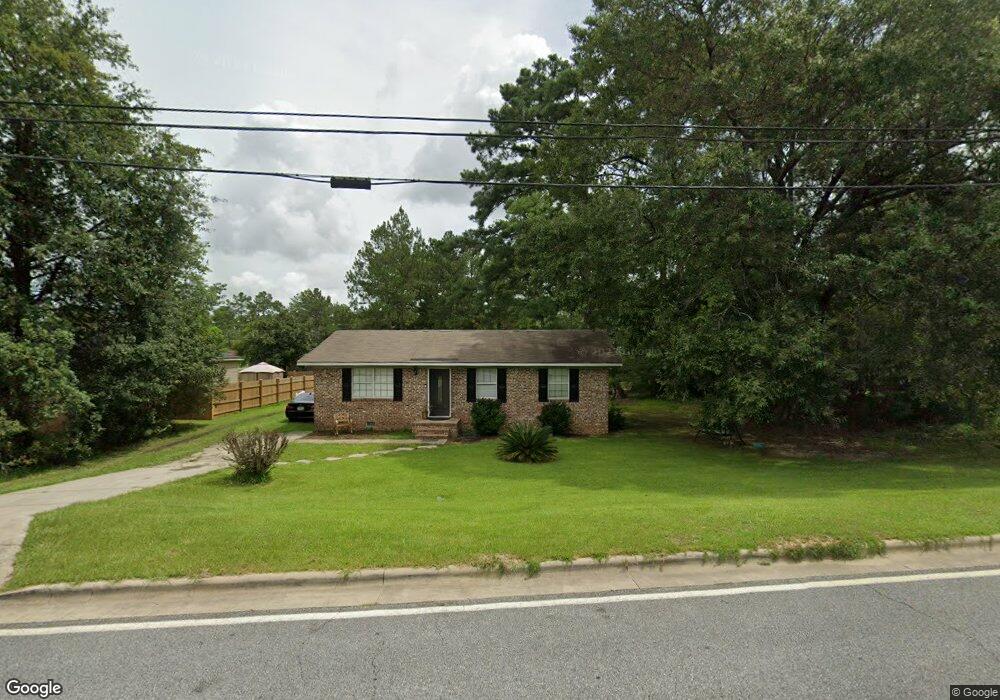
602 Northside Dr Moultrie, GA 31768
Estimated Value: $55,119 - $137,000
--
Bed
1
Bath
1,040
Sq Ft
$87/Sq Ft
Est. Value
About This Home
This home is located at 602 Northside Dr, Moultrie, GA 31768 and is currently estimated at $90,530, approximately $87 per square foot. 602 Northside Dr is a home located in Colquitt County with nearby schools including C.A. Gray Junior High School, Willie J. Williams Middle School, and Colquitt County High School.
Ownership History
Date
Name
Owned For
Owner Type
Purchase Details
Closed on
Sep 16, 2014
Sold by
Reeves Properties Lp
Bought by
Ponder Tywana Lakeeya
Current Estimated Value
Home Financials for this Owner
Home Financials are based on the most recent Mortgage that was taken out on this home.
Original Mortgage
$54,000
Outstanding Balance
$29,835
Interest Rate
4.15%
Mortgage Type
New Conventional
Estimated Equity
$60,695
Purchase Details
Closed on
Nov 6, 2012
Sold by
Lamons Nijeri Necole
Bought by
Reeves Properties Lp
Purchase Details
Closed on
Mar 10, 2011
Sold by
Reeves Properties Lp
Bought by
Lamons Nijeri Necole
Purchase Details
Closed on
Aug 6, 2010
Sold by
Tyson Betty S
Bought by
Reeves Properties Lp
Purchase Details
Closed on
Sep 3, 1982
Sold by
Williams Tom G
Bought by
Tyson Betty S
Create a Home Valuation Report for This Property
The Home Valuation Report is an in-depth analysis detailing your home's value as well as a comparison with similar homes in the area
Home Values in the Area
Average Home Value in this Area
Purchase History
| Date | Buyer | Sale Price | Title Company |
|---|---|---|---|
| Ponder Tywana Lakeeya | $55,000 | -- | |
| Reeves Properties Lp | $54,800 | -- | |
| Lamons Nijeri Necole | $55,000 | -- | |
| Reeves Properties Lp | $15,000 | -- | |
| Tyson Betty S | $30,500 | -- |
Source: Public Records
Mortgage History
| Date | Status | Borrower | Loan Amount |
|---|---|---|---|
| Open | Ponder Tywana Lakeeya | $54,000 |
Source: Public Records
Tax History Compared to Growth
Tax History
| Year | Tax Paid | Tax Assessment Tax Assessment Total Assessment is a certain percentage of the fair market value that is determined by local assessors to be the total taxable value of land and additions on the property. | Land | Improvement |
|---|---|---|---|---|
| 2024 | $428 | $15,959 | $1,200 | $14,759 |
| 2023 | $482 | $17,913 | $1,200 | $16,713 |
| 2022 | $569 | $16,992 | $1,200 | $15,792 |
| 2021 | $508 | $14,989 | $1,200 | $13,789 |
| 2020 | $517 | $14,989 | $1,200 | $13,789 |
| 2019 | $582 | $14,989 | $1,200 | $13,789 |
| 2018 | $599 | $14,989 | $1,200 | $13,789 |
| 2017 | $576 | $14,989 | $1,200 | $13,789 |
| 2016 | $599 | $14,989 | $1,200 | $13,789 |
| 2015 | $600 | $14,989 | $1,200 | $13,789 |
| 2014 | $561 | $13,686 | $1,200 | $12,486 |
| 2013 | -- | $13,685 | $1,200 | $12,485 |
Source: Public Records
Map
Nearby Homes
- 1208 Maple St
- 722 Martin Luther King jr Dr
- 316 5th Ave NW
- 521 5th Ave NW
- 615 1st St NW
- 503 2nd St NW
- 417 9th St NW
- 408 9th St NW
- 614 2nd Ave NW
- 410 W Bypass Pass NW
- 610 1st Ave NW
- 0 S U Highway 319 N
- 410 West Bypass NW
- 1321 Hallmark Dr
- 310 1st Ave SW
- 00 1st Ave SW
- 118 5th St SW
- 618 2nd Ave SW
- 221 6th St SW
- 908 3rd Ave SW