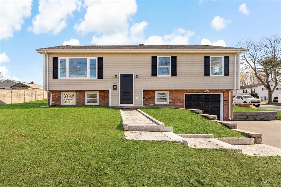
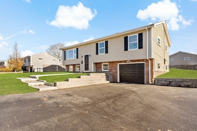
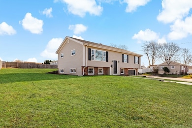
602 Regan Rd Somerset, MA 02726
Pottersville NeighborhoodEstimated payment $3,336/month
Highlights
- Very Popular Property
- Corner Lot
- 1 Car Attached Garage
- Raised Ranch Architecture
- No HOA
- Tile Flooring
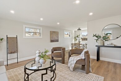
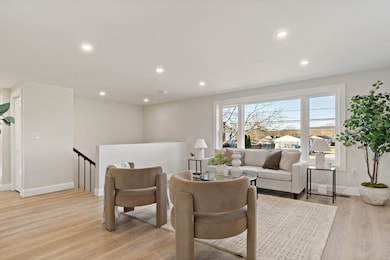
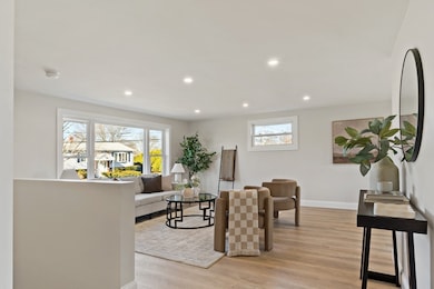
About This Home
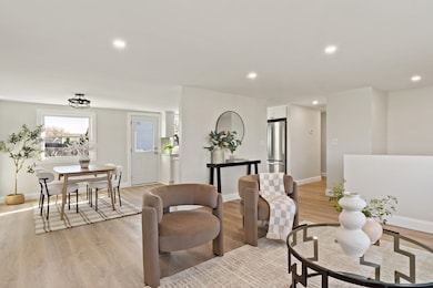
Highest & Best Offers due Tuesday 12/9 at 1 pm! Welcome to 602 Regan Road in Somerset...the closest thing to new construction—without the new-construction price tag! This completely remodeled 3-bed, 2-bath home in Somerset’s desirable Americana Terrace neighborhood has been rebuilt down to the studs and reimagined with a bright, open layout. You are greeted by a new driveway, a one-car garage and a stunning, brand new granite walk-way. The main level of the home features a generously sized kitchen with granite counter tops, stainless steel appliances, plenty of cabinet space and an open layout into your dining and living room. This level also hosts a full bathroom and 3 nicely sized bedrooms. The lower level offers flexibility for an in-law setup, guest space, or a full entertainment zone, with laundry hookups and second full bath. Sitting proudly on a corner lot, this home delivers modern style, brand-new systems throughout, and affordable luxury in one turnkey package.
Home Details
Home Type
- Single Family
Est. Annual Taxes
- $5,425
Year Built
- Built in 1965
Lot Details
- 9,148 Sq Ft Lot
- Corner Lot
- Property is zoned R1
Parking
- 1 Car Attached Garage
- Driveway
- Open Parking
Home Design
- Raised Ranch Architecture
- Shingle Roof
- Concrete Perimeter Foundation
Interior Spaces
- 1,743 Sq Ft Home
- Finished Basement
- Basement Fills Entire Space Under The House
Kitchen
- Range
- Microwave
- Dishwasher
Flooring
- Tile
- Vinyl
Bedrooms and Bathrooms
- 3 Bedrooms
- 2 Full Bathrooms
Utilities
- Forced Air Heating and Cooling System
- 1 Cooling Zone
- Heating System Uses Natural Gas
- 100 Amp Service
- Gas Water Heater
Community Details
- No Home Owners Association
Listing and Financial Details
- Assessor Parcel Number M:0D8 L:0180,2954439
Map
Home Values in the Area
Average Home Value in this Area
Tax History
| Year | Tax Paid | Tax Assessment Tax Assessment Total Assessment is a certain percentage of the fair market value that is determined by local assessors to be the total taxable value of land and additions on the property. | Land | Improvement |
|---|---|---|---|---|
| 2025 | $5,425 | $407,900 | $178,800 | $229,100 |
| 2024 | $5,042 | $394,200 | $178,800 | $215,400 |
| 2023 | $4,448 | $350,800 | $155,300 | $195,500 |
| 2022 | $4,105 | $308,900 | $133,900 | $175,000 |
| 2021 | $4,135 | $281,700 | $120,900 | $160,800 |
| 2020 | $4,123 | $270,900 | $121,000 | $149,900 |
| 2019 | $4,670 | $255,900 | $121,000 | $134,900 |
| 2018 | $4,001 | $235,900 | $116,600 | $119,300 |
| 2017 | $3,906 | $224,500 | $111,200 | $113,300 |
| 2016 | $3,931 | $224,500 | $111,200 | $113,300 |
| 2015 | $3,650 | $210,400 | $106,200 | $104,200 |
| 2014 | $5,149 | $213,200 | $103,200 | $110,000 |
Property History
| Date | Event | Price | List to Sale | Price per Sq Ft |
|---|---|---|---|---|
| 12/04/2025 12/04/25 | For Sale | $549,900 | -- | $315 / Sq Ft |
Purchase History
| Date | Type | Sale Price | Title Company |
|---|---|---|---|
| Foreclosure Deed | $300,000 | None Available | |
| Foreclosure Deed | $300,000 | None Available | |
| Deed | -- | -- | |
| Deed | $42,768 | -- | |
| Deed | $85,535 | -- | |
| Deed | $42,768 | -- | |
| Deed | -- | -- | |
| Deed | $42,768 | -- | |
| Deed | $85,535 | -- |
Mortgage History
| Date | Status | Loan Amount | Loan Type |
|---|---|---|---|
| Previous Owner | $150,000 | Purchase Money Mortgage | |
| Previous Owner | $0 | Purchase Money Mortgage | |
| Previous Owner | $58,250 | No Value Available |
Source: MLS Property Information Network (MLS PIN)
MLS Number: 73459785
APN: SOME-000008D-000000-000180
Disclaimer: Certain information contained herein is derived from information provided by parties other than Homes.com. All information provided is deemed reliable, but is not guaranteed to be accurate and should be independently verified.
![]() The property listing data and information, or the Images, set forth herein were provided to MLS Property Information Network, Inc. from third party sources, including sellers, lessors and public records, and were compiled by MLS Property Information Network, Inc. The property listing data and information, and the Images, are for the personal, non-commercial use of consumers having a good faith interest in purchasing or leasing listed properties of the type displayed to them and may not be used for any purpose other than to identify prospective properties which such consumers may have a good faith interest in purchasing or leasing. MLS Property Information Network, Inc. and its subscribers disclaim any and all representations and warranties as to the accuracy of the property listing data and information, or as to the accuracy of any of the Images, set forth herein.
The property listing data and information, or the Images, set forth herein were provided to MLS Property Information Network, Inc. from third party sources, including sellers, lessors and public records, and were compiled by MLS Property Information Network, Inc. The property listing data and information, and the Images, are for the personal, non-commercial use of consumers having a good faith interest in purchasing or leasing listed properties of the type displayed to them and may not be used for any purpose other than to identify prospective properties which such consumers may have a good faith interest in purchasing or leasing. MLS Property Information Network, Inc. and its subscribers disclaim any and all representations and warranties as to the accuracy of the property listing data and information, or as to the accuracy of any of the Images, set forth herein.
- 112 Rounseville Ave
- 122 Robin Ln
- 95 Samson Ave
- 1067 Bark St
- 65 Marvel St
- 190 Gibbs St
- 171 Marvel St
- 435 Fairway Dr
- 95 Brookside Rd
- 345 Chace St
- 107 Manchester Ave
- 154 Tess Abigail Ln
- 259 Lynch Ave
- 745 Bark St
- 165 Yankee Peddler Dr
- 0 Palmer St
- 135 Grove Ave
- 81 Wood St
- 51 Linden Dr
- 0 Bark St Unit 1342599
- 618 Wood St
- 218-220 Old Colony Ave Unit 202
- 297 Swansom Rd
- 108 Shawomet Ave Unit 3
- 24 Rolling Green Dr
- 53 Bowker Terrace Unit 2
- 4700 N Main St Unit 3E
- 4380 N Main St Unit G3
- 4380 N Main St Unit 401
- 4980 N Main St
- 4000 N Main St Unit 1
- 4000 N Main St Unit 16
- 76 Houlton St Unit 1
- 5500 N Main St
- 1212 Riverside Ave Unit Furnished 2 Bed
- 508 Grand Army of the Republic Highway St
- 37 Courtney St
- 122 Stowe St Unit 122
- 120 Stowe St Unit 120
- 110 Stowe St
