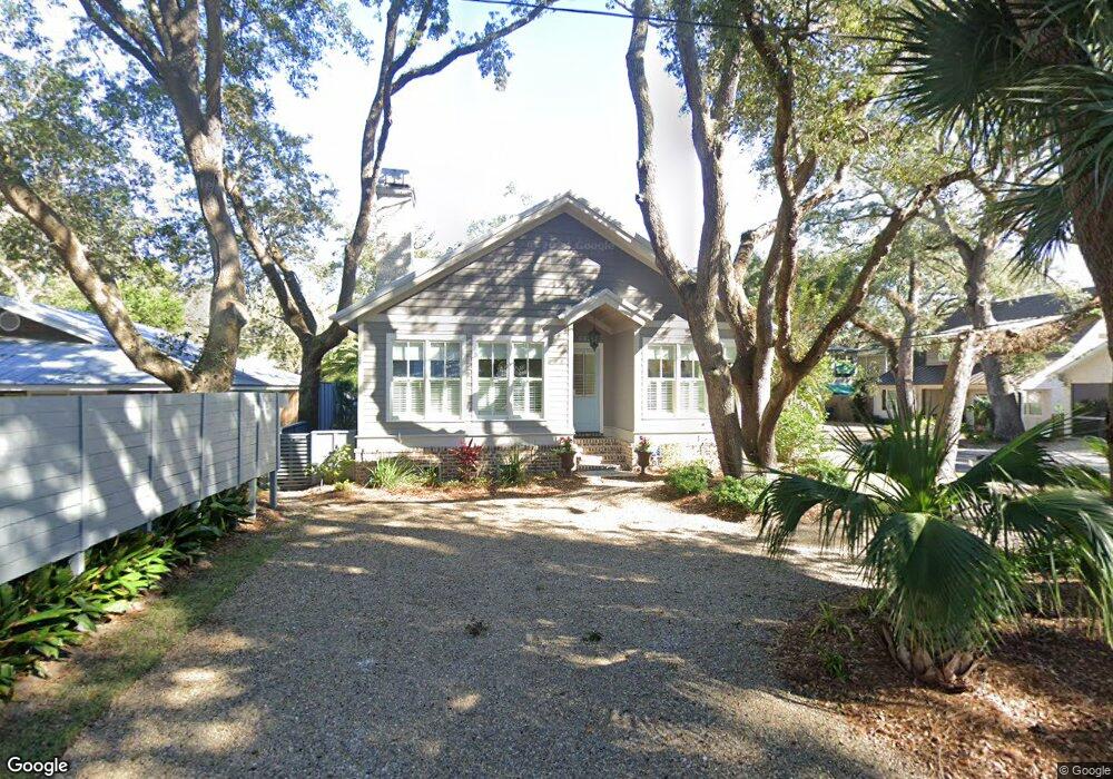
602 Seabreeze Dr Saint Simons Island, GA 31522
Estimated Value: $1,532,898 - $1,773,000
4
Beds
3
Baths
2,191
Sq Ft
$735/Sq Ft
Est. Value
About This Home
This home is located at 602 Seabreeze Dr, Saint Simons Island, GA 31522 and is currently estimated at $1,609,475, approximately $734 per square foot. 602 Seabreeze Dr is a home with nearby schools including St. Simons Elementary School, Glynn Middle School, and Glynn Academy.
Ownership History
Date
Name
Owned For
Owner Type
Purchase Details
Closed on
Jul 10, 2015
Sold by
Glenn Alice
Bought by
Mattingly Susan and Mattingly Cecil
Current Estimated Value
Purchase Details
Closed on
Sep 6, 2011
Sold by
Anderson James M
Bought by
Glenn Alice
Purchase Details
Closed on
Oct 16, 2007
Sold by
Anderson Juanita
Bought by
Anderson James M
Purchase Details
Closed on
Oct 9, 2007
Sold by
Hires William Jefferson
Bought by
Anderson James M
Create a Home Valuation Report for This Property
The Home Valuation Report is an in-depth analysis detailing your home's value as well as a comparison with similar homes in the area
Home Values in the Area
Average Home Value in this Area
Purchase History
| Date | Buyer | Sale Price | Title Company |
|---|---|---|---|
| Mattingly Susan | $250,000 | -- | |
| Glenn Alice | $200,000 | -- | |
| Anderson James M | -- | -- | |
| Anderson James M | -- | -- |
Source: Public Records
Tax History Compared to Growth
Tax History
| Year | Tax Paid | Tax Assessment Tax Assessment Total Assessment is a certain percentage of the fair market value that is determined by local assessors to be the total taxable value of land and additions on the property. | Land | Improvement |
|---|---|---|---|---|
| 2025 | $14,541 | $579,800 | $193,520 | $386,280 |
| 2024 | $9,619 | $383,560 | $152,400 | $231,160 |
| 2023 | $1,977 | $383,560 | $152,400 | $231,160 |
| 2022 | $2,138 | $328,320 | $152,400 | $175,920 |
| 2021 | $2,196 | $251,080 | $96,760 | $154,320 |
| 2020 | $2,249 | $251,080 | $96,760 | $154,320 |
| 2019 | $2,249 | $251,080 | $96,760 | $154,320 |
| 2018 | $2,249 | $231,440 | $87,080 | $144,360 |
| 2017 | $2,085 | $214,920 | $87,080 | $127,840 |
| 2016 | $2,090 | $87,080 | $87,080 | $0 |
| 2015 | -- | $72,000 | $72,000 | $0 |
| 2014 | -- | $72,000 | $72,000 | $0 |
Source: Public Records
Map
Nearby Homes
- 1104 Sherman Ave
- 1055 College St
- 1017 Ocean View Ave
- 405 Everett St
- 105 Seaside Cir
- 115 Seaside Cir
- 1106 George Lotson Ave
- 908 Ocean Blvd
- 1035 Beachview Dr Unit 19
- 1035 Beachview Dr Unit 201
- 322 5th St
- 907 Beachview Dr
- 1028 Beachview Dr Unit 5
- 1028 Beachview Dr Unit 2
- 1153 Ocean Blvd
- 638 Dellwood Ave
- 1145 Park Ln
- 200 Salt Air Dr Unit 152
- 200 Salt Air Dr Unit 154
- 200 Salt Air Dr Unit 139
- 1069 Sherman Ave
- 604 Seabreeze Dr
- 1061 Sherman Ave
- 608 Seabreeze Dr
- 518 Sea Breeze Dr
- 1057 Sherman Ave
- 515 Seabreeze Dr
- 612 Seabreeze Dr
- 1070 Sherman
- 1079 Sherman Ave
- 609 Seabreeze Dr
- 1058 Sherman Ave
- 1056 Sherman Ave
- 609 Beach Dr
- 1053 Sherman Ave Unit 5
- 1053 Sherman Ave
- 521 Beach Dr
- 617 Seabreeze Dr
- 616 Seabreeze Dr
- 514 Seabreeze Dr