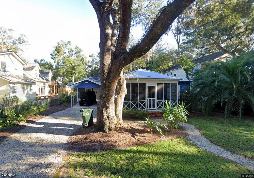
603 May Joe St Saint Simons Island, GA 31522
Estimated Value: $762,197 - $1,244,000
3
Beds
2
Baths
1,800
Sq Ft
$513/Sq Ft
Est. Value
About This Home
This home is located at 603 May Joe St, Saint Simons Island, GA 31522 and is currently estimated at $924,049, approximately $513 per square foot. 603 May Joe St is a home located in Glynn County with nearby schools including St. Simons Elementary School, Glynn Middle School, and Glynn Academy.
Ownership History
Date
Name
Owned For
Owner Type
Purchase Details
Closed on
Jul 23, 2010
Sold by
Federal National Mortgage Association
Bought by
Tilley Ralph H and Tilley Kathryn W
Current Estimated Value
Home Financials for this Owner
Home Financials are based on the most recent Mortgage that was taken out on this home.
Original Mortgage
$243,100
Outstanding Balance
$161,381
Interest Rate
4.7%
Mortgage Type
New Conventional
Estimated Equity
$762,668
Purchase Details
Closed on
May 4, 2010
Sold by
Jpmorgan Chase Bank National Association
Bought by
Federal National Mortgage Association
Create a Home Valuation Report for This Property
The Home Valuation Report is an in-depth analysis detailing your home's value as well as a comparison with similar homes in the area
Home Values in the Area
Average Home Value in this Area
Purchase History
| Date | Buyer | Sale Price | Title Company |
|---|---|---|---|
| Tilley Ralph H | $286,000 | -- | |
| Federal National Mortgage Association | $268,846 | -- | |
| Jpmorgan Chase Bank National Association | $268,846 | -- |
Source: Public Records
Mortgage History
| Date | Status | Borrower | Loan Amount |
|---|---|---|---|
| Open | Tilley Ralph H | $243,100 |
Source: Public Records
Tax History Compared to Growth
Tax History
| Year | Tax Paid | Tax Assessment Tax Assessment Total Assessment is a certain percentage of the fair market value that is determined by local assessors to be the total taxable value of land and additions on the property. | Land | Improvement |
|---|---|---|---|---|
| 2025 | $7,029 | $280,280 | $175,160 | $105,120 |
| 2024 | $5,696 | $227,120 | $125,120 | $102,000 |
| 2023 | $3,400 | $227,120 | $125,120 | $102,000 |
| 2022 | $3,371 | $204,440 | $125,120 | $79,320 |
| 2021 | $3,472 | $159,480 | $125,120 | $34,360 |
| 2020 | $3,503 | $159,480 | $125,120 | $34,360 |
| 2019 | $3,635 | $134,440 | $100,080 | $34,360 |
| 2018 | $3,047 | $111,920 | $77,560 | $34,360 |
| 2017 | $3,047 | $111,920 | $77,560 | $34,360 |
| 2016 | $2,811 | $111,920 | $77,560 | $34,360 |
| 2015 | $2,822 | $111,920 | $77,560 | $34,360 |
| 2014 | $2,822 | $111,920 | $77,560 | $34,360 |
Source: Public Records
Map
Nearby Homes
- 553 Magnolia Ave
- 625 May Joe St
- 638 Dellwood Ave
- 548 Oglethorpe Ave Unit 11
- 540 Oglethorpe Ave
- 652 Oglethorpe Ave
- 115 Seaside Cir
- 425 Magnolia Ave Unit C
- 424 Magnolia Ave Unit 6
- 105 Seaside Cir
- 622 Beachview Dr
- 744 Ocean Blvd Unit 202
- 416 Magnolia Ave
- 1106 George Lotson Ave
- 800 Ocean Blvd Unit 204
- 800 Ocean Blvd Unit 108
- 30 Admirals Cove
- 400 Ocean Blvd Unit 2207
- 400 Ocean Blvd Unit 2100
- 400 Ocean Blvd Unit 2307