Estimated Value: $296,853 - $354,000
4
Beds
3
Baths
2,100
Sq Ft
$152/Sq Ft
Est. Value
About This Home
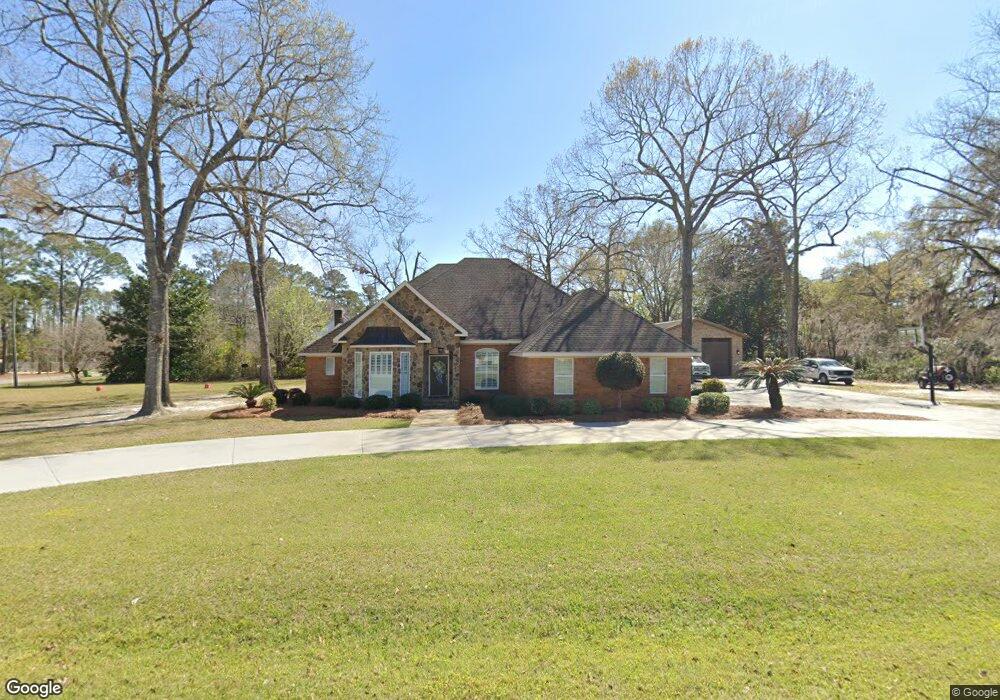
This home is located at 603 Newton Dr, Adel, GA 31620 and is currently estimated at $318,713, approximately $151 per square foot. 603 Newton Dr is a home located in Cook County with nearby schools including Cook Primary School, Cook Elementary School, and Cook County Middle School.
Ownership History
Date
Name
Owned For
Owner Type
Purchase Details
Closed on
Sep 27, 2013
Sold by
Phillips Bobby Keith
Bought by
Cowart Walter E and Cowart Kristie G
Current Estimated Value
Home Financials for this Owner
Home Financials are based on the most recent Mortgage that was taken out on this home.
Original Mortgage
$220,353
Outstanding Balance
$165,771
Interest Rate
4.53%
Mortgage Type
New Conventional
Estimated Equity
$152,942
Purchase Details
Closed on
Mar 16, 2009
Sold by
Grimsley Dianne T and Kelley Dianne T
Bought by
Phillips Bobby Keith and Phillips Lisa M
Purchase Details
Closed on
Apr 12, 2005
Sold by
Grimsley Phillip W
Bought by
Kelley Dianne T
Home Financials for this Owner
Home Financials are based on the most recent Mortgage that was taken out on this home.
Original Mortgage
$100,000
Interest Rate
5.88%
Mortgage Type
New Conventional
Create a Home Valuation Report for This Property
The Home Valuation Report is an in-depth analysis detailing your home's value as well as a comparison with similar homes in the area
Home Values in the Area
Average Home Value in this Area
Purchase History
| Date | Buyer | Sale Price | Title Company |
|---|---|---|---|
| Cowart Walter E | $230,353 | -- | |
| Phillips Bobby Keith | $245,000 | -- | |
| Kelley Dianne T | $170,000 | -- |
Source: Public Records
Mortgage History
| Date | Status | Borrower | Loan Amount |
|---|---|---|---|
| Open | Cowart Walter E | $220,353 | |
| Previous Owner | Kelley Dianne T | $100,000 |
Source: Public Records
Tax History Compared to Growth
Tax History
| Year | Tax Paid | Tax Assessment Tax Assessment Total Assessment is a certain percentage of the fair market value that is determined by local assessors to be the total taxable value of land and additions on the property. | Land | Improvement |
|---|---|---|---|---|
| 2024 | $3,650 | $112,440 | $22,400 | $90,040 |
| 2023 | $3,170 | $97,880 | $20,000 | $77,880 |
| 2022 | $3,170 | $97,880 | $20,000 | $77,880 |
| 2021 | $2,913 | $84,200 | $20,000 | $64,200 |
| 2020 | $2,913 | $84,200 | $20,000 | $64,200 |
| 2019 | $2,915 | $84,200 | $20,000 | $64,200 |
| 2018 | $2,974 | $84,200 | $20,000 | $64,200 |
| 2017 | $2,918 | $84,200 | $20,000 | $64,200 |
| 2016 | $2,922 | $84,200 | $20,000 | $64,200 |
| 2015 | $3,015 | $86,700 | $22,500 | $64,200 |
| 2014 | $3,019 | $86,700 | $22,500 | $64,200 |
| 2013 | -- | $86,700 | $22,500 | $64,200 |
Source: Public Records
Map
Nearby Homes
- 701 Gloria St
- 315 Newton Dr
- 901 E 4th St
- 418 E 3rd St
- 625 Coxstill Rd
- 1306 Bear Creek Rd
- 1402 Bear Creek Rd
- 304 E 3rd St
- 322 Magnolia Dr
- 211 S Gordon Ave
- 415 E 8th St
- 804 S Forrest Ave
- 2302 Thomas St
- 808 Laurel Ave
- 806 S Forrest Ave
- 808 S Laurel Ave
- 2503 Dianne St
- 2601 Massee Post Rd
- 507 S Poplar St
- 2603 Dianne St
- 601 Newton Dr
- 0 Plantation Dr Unit 70743
- 0 Plantation Dr Unit 70742
- 0 Plantation Dr Unit 121826
- 605 Newton Dr
- 606 Newton Dr
- 608 Newton Dr
- 501 Newton Dr
- 721 Tyson Cir
- 502 Newton Dr
- 721 Tyson Cir
- 610 Newton Dr
- 604 Newton Dr
- 600 Newton Dr
- 902 Plantation Dr
- 701 Newton Dr
- 834 Plantation Dr
- 905 Plantation Dr
- 403 Newton Dr
- 700 Newton Dr