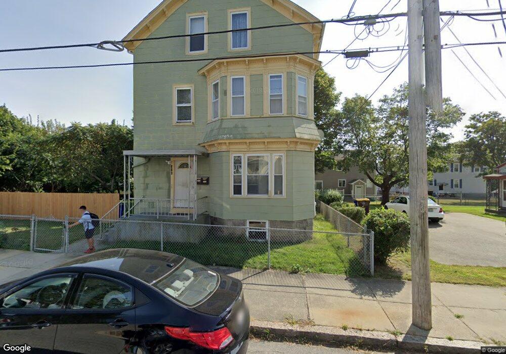
603 Orswell St Fall River, MA 02721
Maplewood NeighborhoodEstimated Value: $388,000 - $452,056
6
Beds
2
Baths
1,901
Sq Ft
$217/Sq Ft
Est. Value
About This Home
This home is located at 603 Orswell St, Fall River, MA 02721 and is currently estimated at $412,764, approximately $217 per square foot. 603 Orswell St is a home located in Bristol County with nearby schools including Letourneau Elementary School, Matthew J. Kuss Middle School, and B M C Durfee High School.
Ownership History
Date
Name
Owned For
Owner Type
Purchase Details
Closed on
Mar 19, 2018
Sold by
Birmingham Gail and Batchelder Paul S
Bought by
Batchelder Paul S and Batchelder Lori A
Current Estimated Value
Purchase Details
Closed on
Jun 23, 2009
Sold by
Batchelder Paul and Batchelder Mary E
Bought by
Batchelder Paul and Batchelder Mary E
Purchase Details
Closed on
Jul 20, 1970
Bought by
Batchelder Paul S and Batchelder Mary E
Create a Home Valuation Report for This Property
The Home Valuation Report is an in-depth analysis detailing your home's value as well as a comparison with similar homes in the area
Home Values in the Area
Average Home Value in this Area
Purchase History
| Date | Buyer | Sale Price | Title Company |
|---|---|---|---|
| Batchelder Paul S | $79,000 | -- | |
| Batchelder Paul | -- | -- | |
| Batchelder Paul S | $13,000 | -- |
Source: Public Records
Tax History Compared to Growth
Tax History
| Year | Tax Paid | Tax Assessment Tax Assessment Total Assessment is a certain percentage of the fair market value that is determined by local assessors to be the total taxable value of land and additions on the property. | Land | Improvement |
|---|---|---|---|---|
| 2025 | $3,672 | $320,700 | $120,400 | $200,300 |
| 2024 | $3,414 | $297,100 | $118,000 | $179,100 |
| 2023 | $3,145 | $256,300 | $106,300 | $150,000 |
| 2022 | $2,713 | $232,200 | $100,300 | $131,900 |
| 2021 | $2,713 | $196,200 | $95,800 | $100,400 |
| 2020 | $2,481 | $171,700 | $91,500 | $80,200 |
| 2019 | $2,477 | $169,900 | $95,600 | $74,300 |
| 2018 | $2,442 | $167,000 | $96,300 | $70,700 |
| 2017 | $2,281 | $162,900 | $96,300 | $66,600 |
| 2016 | $2,238 | $164,200 | $99,300 | $64,900 |
| 2015 | $2,318 | $177,200 | $99,300 | $77,900 |
| 2014 | $2,320 | $184,400 | $99,300 | $85,100 |
Source: Public Records
Map
Nearby Homes
- 539 Aetna St
- 59 Wayne St
- 478 Tucker St
- 125 Carl St
- 80 Lane St
- 256 Rhode Island Ave
- 323 S Oxford St
- 1553 Rodman St
- 59 Denver St
- 415 Anthony St
- 306 Mott St
- 191 Glasgow St Unit 2
- 191 Glasgow St Unit 1
- 495 Chicago St
- 215 Cambridge St
- 239 Glasgow St Unit 8
- 493 Peckham St
- 352 Vale St Unit 1
- 340 Vale St
- 49 Stafford Rd
- 574 Tower St
- 588 Tower St
- 585 Orswell St
- 568 Tower St
- 631 Orswell St
- 616 Orswell St
- 602 Tower St
- 602 Orswell St
- 624 Orswell St
- 624 Orswell St Unit 3
- 624 Orswell St Unit 2
- 641 Orswell St
- 596 Orswell St
- 550 Tower St
- 614 Tower St
- 683 Stafford Rd Unit 685
- 675 Stafford Rd
- 707 Stafford Rd
- 585 Tower St
- 557 Tower St