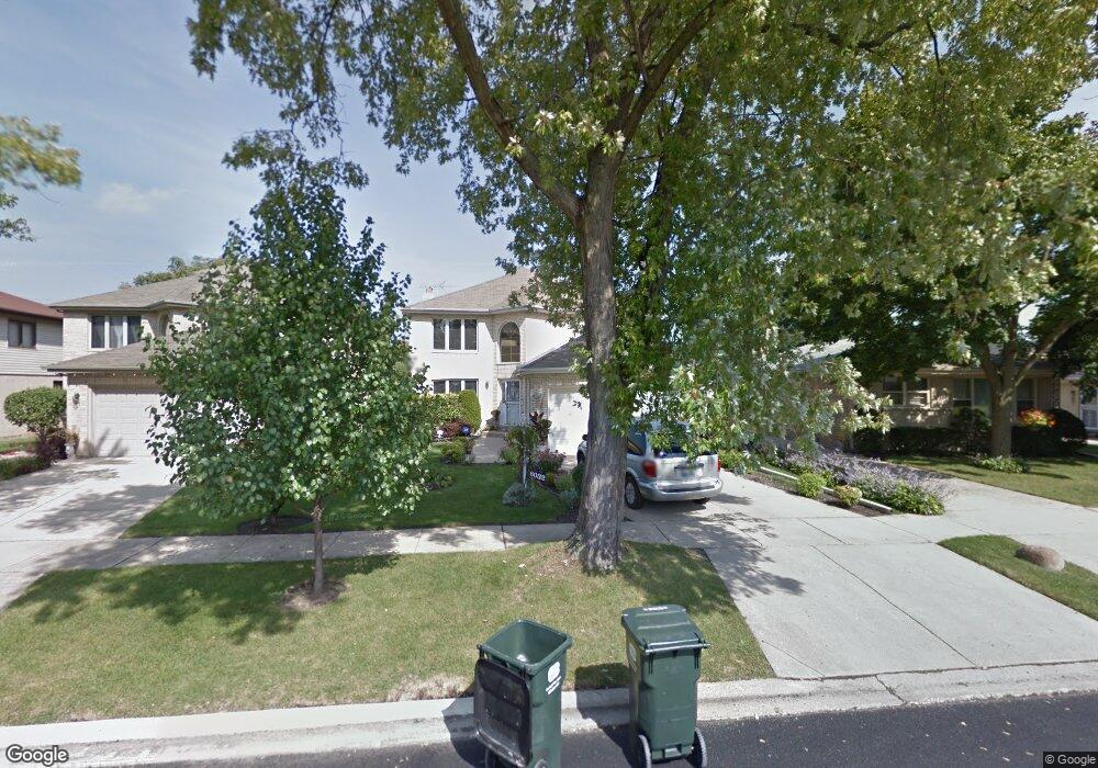
6032 Carol Ave Morton Grove, IL 60053
Estimated Value: $626,000 - $671,000
4
Beds
3
Baths
2,658
Sq Ft
$241/Sq Ft
Est. Value
About This Home
This home is located at 6032 Carol Ave, Morton Grove, IL 60053 and is currently estimated at $640,967, approximately $241 per square foot. 6032 Carol Ave is a home located in Cook County with nearby schools including Park View Elementary School, Niles West High School, and St John Brebeuf School.
Ownership History
Date
Name
Owned For
Owner Type
Purchase Details
Closed on
Mar 15, 1997
Sold by
Lasalle National Bank
Bought by
Sharma Arun K and Sharma Phoola Rani
Current Estimated Value
Home Financials for this Owner
Home Financials are based on the most recent Mortgage that was taken out on this home.
Original Mortgage
$160,000
Outstanding Balance
$19,730
Interest Rate
7.93%
Estimated Equity
$621,237
Create a Home Valuation Report for This Property
The Home Valuation Report is an in-depth analysis detailing your home's value as well as a comparison with similar homes in the area
Home Values in the Area
Average Home Value in this Area
Purchase History
| Date | Buyer | Sale Price | Title Company |
|---|---|---|---|
| Sharma Arun K | $336,000 | -- |
Source: Public Records
Mortgage History
| Date | Status | Borrower | Loan Amount |
|---|---|---|---|
| Open | Sharma Arun K | $160,000 |
Source: Public Records
Tax History Compared to Growth
Tax History
| Year | Tax Paid | Tax Assessment Tax Assessment Total Assessment is a certain percentage of the fair market value that is determined by local assessors to be the total taxable value of land and additions on the property. | Land | Improvement |
|---|---|---|---|---|
| 2024 | $9,353 | $48,030 | $7,627 | $40,403 |
| 2023 | $9,194 | $48,030 | $7,627 | $40,403 |
| 2022 | $9,194 | $48,030 | $7,627 | $40,403 |
| 2021 | $10,433 | $39,589 | $4,693 | $34,896 |
| 2020 | $9,460 | $39,589 | $4,693 | $34,896 |
| 2019 | $9,378 | $44,483 | $4,693 | $39,790 |
| 2018 | $10,371 | $39,737 | $4,253 | $35,484 |
| 2017 | $10,701 | $39,737 | $4,253 | $35,484 |
| 2016 | $13,191 | $46,515 | $4,253 | $42,262 |
| 2015 | $12,379 | $41,037 | $3,666 | $37,371 |
| 2014 | $12,755 | $42,191 | $3,666 | $38,525 |
| 2013 | $12,787 | $43,280 | $3,666 | $39,614 |
Source: Public Records
Map
Nearby Homes
- 8849 Mcvicker Ave
- 8836 Mansfield Ave
- 6020 Lincoln Ave Unit 407
- 6035 Lincoln Ave
- 6330 Hennings Ct
- 8712 Ferris Ave
- 6332 Hennings Ct
- 6334 Hennings Ct
- 6336 Hennings Ct
- 6338 Hennings Ct
- 8841 Menard Ave
- 6340 Hennings Ct
- 6342 Hennings Ct
- 6344 Hennings Ct
- 6346 Hennings Ct
- 6140 Elm St
- 6330 Lincoln Ave Unit 2E
- 6330 Lincoln Ave Unit 2A
- 6166 Mayfair St Unit 33714
- 8425 Callie Ave Unit 62
- 6036 Carol Ave
- 6028 Carol Ave
- 6020 Carol Ave
- 6040 Carol Ave
- 6016 Carol Ave
- 6065 Dempster St
- 6044 Carol Ave
- 6037 Dempster St
- 6069 Dempster St
- 6041 Dempster St
- 6027 Carol Ave
- 6031 Carol Ave
- 6023 Carol Ave
- 6035 Carol Ave
- 6021 Carol Ave
- 6048 Carol Ave
- 6012 Carol Ave
- 6021 Dempster St
- 6039 Carol Ave
- 6027 W Dempster St