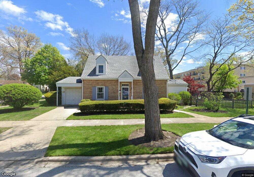
6033 Grove Ct Morton Grove, IL 60053
Estimated Value: $389,000 - $464,000
3
Beds
1
Bath
1,359
Sq Ft
$318/Sq Ft
Est. Value
About This Home
This home is located at 6033 Grove Ct, Morton Grove, IL 60053 and is currently estimated at $432,546, approximately $318 per square foot. 6033 Grove Ct is a home located in Cook County with nearby schools including Park View Elementary School, Niles West High School, and Arie Crown Hebrew Day School.
Ownership History
Date
Name
Owned For
Owner Type
Purchase Details
Closed on
Feb 28, 2022
Sold by
Frank Diane R and The Helen M Estes Living Trust
Bought by
Dehne Ruth R and The Ruth R Dehne Living Trust
Current Estimated Value
Purchase Details
Closed on
Feb 21, 2022
Sold by
Frank Diane R and The Helen M Estes Living Trust
Bought by
The Ruth R Dehne Living Trust and Dehne
Purchase Details
Closed on
Jan 5, 2022
Sold by
Frank Diane R and The Helen M Estes Living Trust
Bought by
Dehne Ruth R and The Ruth R Dehne Living Trust
Purchase Details
Closed on
Jun 1, 2012
Sold by
Estes Helen M
Bought by
Estes Helen M and The Helen M Estes Living Trust
Create a Home Valuation Report for This Property
The Home Valuation Report is an in-depth analysis detailing your home's value as well as a comparison with similar homes in the area
Home Values in the Area
Average Home Value in this Area
Purchase History
| Date | Buyer | Sale Price | Title Company |
|---|---|---|---|
| Dehne Ruth R | $370,000 | -- | |
| The Ruth R Dehne Living Trust | $370,000 | -- | |
| Dehne Ruth R | $370,000 | -- | |
| Estes Helen M | -- | None Available |
Source: Public Records
Tax History Compared to Growth
Tax History
| Year | Tax Paid | Tax Assessment Tax Assessment Total Assessment is a certain percentage of the fair market value that is determined by local assessors to be the total taxable value of land and additions on the property. | Land | Improvement |
|---|---|---|---|---|
| 2024 | $8,097 | $34,000 | $10,854 | $23,146 |
| 2023 | $7,662 | $34,000 | $10,854 | $23,146 |
| 2022 | $7,662 | $34,000 | $10,854 | $23,146 |
| 2021 | $6,692 | $26,859 | $6,679 | $20,180 |
| 2020 | $6,642 | $26,859 | $6,679 | $20,180 |
| 2019 | $6,722 | $30,179 | $6,679 | $23,500 |
| 2018 | $6,839 | $27,857 | $6,053 | $21,804 |
| 2017 | $8,856 | $27,857 | $6,053 | $21,804 |
| 2016 | $7,065 | $27,857 | $6,053 | $21,804 |
| 2015 | $6,527 | $24,753 | $5,218 | $19,535 |
| 2014 | $6,551 | $24,753 | $5,218 | $19,535 |
| 2013 | $6,368 | $24,753 | $5,218 | $19,535 |
Source: Public Records
Map
Nearby Homes
- 6020 Lincoln Ave Unit 407
- 6035 Lincoln Ave
- 6140 Elm St
- 6166 Mayfair St Unit 33714
- 8425 Callie Ave Unit 62
- 6163 Mayfair St Unit 102714
- 8400 Callie Ave Unit D209
- 8400 Callie Ave Unit D207
- 8300 Callie Ave Unit F314
- 8300 Callie Ave Unit F610
- 6330 Lincoln Ave Unit 2E
- 6330 Lincoln Ave Unit 2A
- 8712 Ferris Ave
- 6330 Hennings Ct
- 6411 Elm St
- 6332 Hennings Ct
- 6338 Hennings Ct
- 6334 Hennings Ct
- 6336 Hennings Ct
- 8849 Mcvicker Ave
- 6025 Grove Ct
- 6023 Grove Ct
- 6021 Grove Ct
- 6032 Lincoln Ave
- 8506 Morton Ave
- 8510 Morton Ave
- 8504 Morton Ave
- 6017 Grove Ct
- 6017 Grove Ct
- 8516 Morton Ave
- 6034 Grove Ct
- 6040 Lincoln Ave
- 6028 Grove Ct
- 8520 Morton Ave
- 6026 Grove Ct
- 6013 Grove Ct
- 6020 Grove Ct
- 8522 Morton Ave
- 6020 Lincoln Ave Unit 209
- 6020 Lincoln Ave Unit 202