Estimated Value: $364,000 - $415,000
4
Beds
2
Baths
1,750
Sq Ft
$228/Sq Ft
Est. Value
About This Home
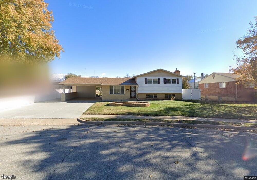
This home is located at 6034 S 2050 W, Roy, UT 84067 and is currently estimated at $398,510, approximately $227 per square foot. 6034 S 2050 W is a home located in Weber County with nearby schools including Municipal School, Roy Junior High School, and Roy High School.
Ownership History
Date
Name
Owned For
Owner Type
Purchase Details
Closed on
May 15, 2024
Sold by
Percival Robert
Bought by
Percival Robert and Percival Andrea Michelle
Current Estimated Value
Home Financials for this Owner
Home Financials are based on the most recent Mortgage that was taken out on this home.
Original Mortgage
$404,936
Outstanding Balance
$399,193
Interest Rate
6.82%
Mortgage Type
VA
Estimated Equity
-$683
Purchase Details
Closed on
Nov 7, 1996
Sold by
Brooks Jack L and Brooks Juanita M
Bought by
Brooks Jack L and Brooks Juanita M
Create a Home Valuation Report for This Property
The Home Valuation Report is an in-depth analysis detailing your home's value as well as a comparison with similar homes in the area
Home Values in the Area
Average Home Value in this Area
Purchase History
| Date | Buyer | Sale Price | Title Company |
|---|---|---|---|
| Percival Robert | -- | Old Republic Title | |
| Percival Robert | -- | Backman Title | |
| Brooks Jack L | -- | -- |
Source: Public Records
Mortgage History
| Date | Status | Borrower | Loan Amount |
|---|---|---|---|
| Open | Percival Robert | $404,936 |
Source: Public Records
Tax History Compared to Growth
Tax History
| Year | Tax Paid | Tax Assessment Tax Assessment Total Assessment is a certain percentage of the fair market value that is determined by local assessors to be the total taxable value of land and additions on the property. | Land | Improvement |
|---|---|---|---|---|
| 2025 | $2,412 | $378,683 | $120,505 | $258,178 |
| 2024 | $2,369 | $206,249 | $66,285 | $139,964 |
| 2023 | $2,267 | $197,450 | $61,354 | $136,096 |
| 2022 | $2,341 | $210,650 | $53,792 | $156,858 |
| 2021 | $1,786 | $261,000 | $68,071 | $192,929 |
| 2020 | $1,696 | $228,000 | $68,071 | $159,929 |
| 2019 | $1,659 | $210,000 | $38,410 | $171,590 |
| 2018 | $1,537 | $182,000 | $36,415 | $145,585 |
| 2017 | $1,352 | $148,000 | $33,600 | $114,400 |
| 2016 | $1,343 | $79,328 | $16,531 | $62,797 |
| 2015 | $1,227 | $73,701 | $16,531 | $57,170 |
| 2014 | $1,237 | $73,701 | $16,531 | $57,170 |
Source: Public Records
Map
Nearby Homes
- 2622 2125 W
- 2622 N 175 W
- 2632 2125 W
- 244 W 2575 N
- 5902 S 1900 W
- 350 W 2575 N
- 389 W 2575 N
- 428 W 2650 N
- 480 W 2650 N
- 484 W 2650 N
- 2512 N 475 W
- 2635 N 500 W Unit 45
- 2593 N 500 W Unit 56
- 2612 N 525 W
- 2486 N 690 W
- 5643 S 2200 W
- 2146 W 5600 S Unit 29
- 5545 S 2100 W Unit 12
- 5545 S 2100 W Unit 20
- 5545 S 2100 W Unit D22